Listed 15 sub titles with search on: Sights for wider area of: "ETOLOAKARNANIA Prefecture GREECE" .
AETOS (Village) ETOLOAKARNANIA
AGIA VARVARA (Village) AKTIO - VONITSA
The castle of Griva, which is a small distance from the bridge of
Lefkas, where the road from
Vonitsa to Lefkada
is intersected by the road to Plagia.
During the Turkish domination there was a mosque in the area, which is why the
place was called "Tekes".
This text (extract) is cited August 2003 from the Municipality
of Kekropia tourist pamphlet.
NAFPAKTOS (Town) ETOLOAKARNANIA
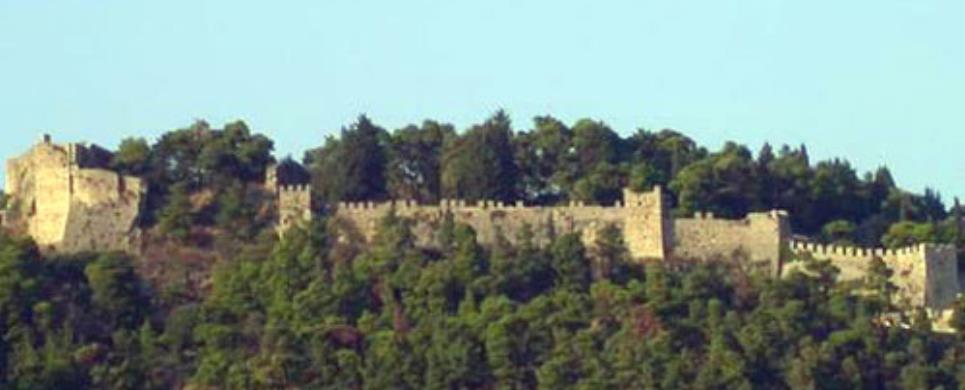
Several architectural phases are distinguished in the fortification
walls of Nafpaktos, dated from the Greek antiquity until the Turkish occupation.
Two walls run down the slope of the hill, starting from the top, one towards the
east, and the other towards the west. Before they reach the coast, they form an
angle and block the entrance to the harbour. Four transverse walls join these
two, thus forming five sections. The enceinte is reinforced with rectangular and
circular towers.
History
The castle is built on the site of the ancient acropolis. Nafpaktos
was destroyed by an earhtquake in A.D. 553 and from the 8th century onwards, it
became the capital of the fifth Theme of Byzantium. It remained under Greek control
until 1204, when it was given away to the Venetians. In 1210, Michael Angelos
Comnenos included the city in the properties of the Despotate of Epiros. In 1294
it came under the control of Philip d'Anjou and in 1360 it was conquered by the
Albanian leader, Ghino Buo Spata. From 1407 until 1444 it was occupied by the
Venetians and then by the Turks, who kept it until 1687. From 1687 until 1699
it was again under the Venetian control and remained under Turkish domination
until 1829.
The site has not been systematically excavated. The trenches that
were opened in 1980-81 to the north of the church of Prophetes Elias brought to
light the remains of a Byzantine bath and a Byzantine church.
Cleaning and consolidation work is conducted every year by the 8th
Ephorate of Byzantine and Classical Antiquities. The crumbling sections of masonry
are repaired and the foundations in all parts of the wall that present stability
problems are restored.
This text is cited December 2004 from the West Greece Region General Secretariat URL below, which contains images.
Several architectural phases are distinguished in the fortification
walls of Naupactos, dated from the Greek antiquity until the Turkish occupation.
Two walls run down the slope of the hill, starting from the top, one towards the
east, and the other towards the west. Before they reach the coast, they form an
angle and block the entrance to the harbour. Four transverse walls join these
two, thus forming five sections. The enceinte is reinforced with rectangular and
circular towers.
The castle is built on the site of the ancient acropolis. Naupactos
was destroyed by an earhtquake in A.D.553 and from the 8th century on, it became
the capital of the fifth Theme of Byzantium. It remained under Greek control until
1204, when it was given away to the Venetians. In 1210, Michael Angelos Comnenos
included the city in the properties of the Despotate of Epiros. In 1294 it came
under the control of Philip d'Anjou and in 1360 was conquered by the Albanian
leader, Ghino Buo Spata. From 1407 until 1444 it was occupied by the Venetians
and then by the Turks, who kept it until 1687. From 1687 until 1699 it was again
under the Venetian control and remained under Turkish domination until 1829.
The site has not been systematically excavated. The trenches opened
in 1980-81 to the north of the church of Prophetes Elias brought to light the
remains of a Byzantine bath and a Byzantine church.
Cleaning and consolidation work is conducted every year by the 8th
Ephorate of Byzantine and Classical Antiquities. The crumbling sections of masonry
are repaired and the foundations in all parts of the wall that present stability
problems are restored.
As well, significant is the Clock
Bell-tower:
A square building
made of dressed stone terminating in a cornice likewise of stone. On two sides
hang the two round faces of the clock. Above it are four little pillars of brickwork,
connected by semi-circular apses. It was built at the beginning of this century
on the site of the Byzantine fortress (castro) of Naupaktos. The site is prominent
and the bell-tower is a fine example of a particular category of architecture.
In 1991 the clock was repaired.
PLAGIA (Village) AKTIO - VONITSA
The castle of Plagia with the name "Agios Georgios"was built
in the 17th century. It has been under preservation since 1998. It is built on
the slope where present Plagia lies and is only a short distance from Lefkas.
Dorpfeld claims that classic Nirikos
stood there, while professor Faraklas claims that "Sollion"
existed in this place.
This text (extract) is cited August 2003 from the Municipality
of Kekropia tourist pamphlet.
ACHELOOS (River) ETOLOAKARNANIA
The Acheloos gorge is between Raptopoulo and Vrouvianon (in Evrytania), with the Temblas bridge, built in 1904.
PALEROS (Small town) AKTIO - VONITSA
PERATIA (Village) AKTIO - VONITSA
KREMASTES LAKE (Lake) ETOLOAKARNANIA
Near the meeting point of the Acheloos river with the Agrafioti and Megdova offshoots, the artificial lake of Kremaston was created in 1965, in which many villages were submerged, from Euritania county as well as Aitolokarnania county. This makes up the largest earth dam of Europe. It has a capacity of 4.700.000.000 cubic meters, that is 11 times greater than Marathon lake. The importance of the lake is due to not only generating electricity and hydrating the surrounding area, but also to increasing the area's biodiversity and its use by migratory birds as a waystation.
This extract is cited August 2003 from the Municipality of Karpenission URL below, which contains images.
ETOLOAKARNANIA (Prefecture) GREECE
Messolongi is the "sacred town" of Greece and it is chiefly
known for the heroic exit of the "free besieged" in the 1821 war of
Independence. Among the sights of interest are the sally port, the Heroes' Garden,
the statue of Lord Byron and the museums. The nearby salt marshes give the town
a unique character. Here one can find the so-called "pelades" that are
fishermen's huts, supported on wooden stilts in the water. In a beautiful spot,
just out of the town is the historic monastery
of Agios Symeon and a little futher out are ancient Plevron
and Kalydon.
Fifteen kilometres out of Messolongi is the small, thickly populated
island of Etloliko, which
is connected to the mainland by a 300 metre-long bridge. The island consists of
a large village and has a long naval tradition.
The second largest town, Agrinio, is a modern settlement with a good
tourist infrastructure and a large tobacco manufacturing industry. It is worth
taking a walk through the small pine grove for a view of the plain and a visit
to the ancient town of Voukatio. One can also combine a visit to Trichonida
lake, the largest lake in Greece with ancient Thermo,
which was the centre of the Etolian league, followed by a tour of the archaeological
sites of Oiniadai and ancient
Strato. Near Agrinio is the
Acheloos dam, which has a span of 1,600 metres, joining Etolia with Akarnania.
However, the jewel in the crown of this prefecture is the Ambracian
gulf and the pretty coastal town of Vonitsa
at its entrance, which is an ideal place to holiday. Another lively coastal resort
on the Ambracian gulf is Menidi.
Nafpaktos, a beautifully
picturesque town built amphitheatrically on the hillside, has a well-preserved
venetian castle and pretty harbour with two watchtowers guarding the entrance.
Significant remains of a medieval castle can also be found at Antirio,
which is now a vital ferry link across the straits to Achaia
in the Peloponnese.
This text is cited December 2004 from the West Greece Region General Secretariat URL below, which contains image.
GAVROLIMNI (Village) NAFPAKTOS
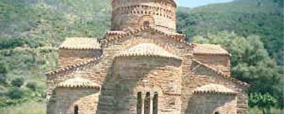
The
church belongs to the domed, cross-in-square type and, more specifically to
the "Helladic transitional type". The walls are built of limestone blocks enclosed
with bricks. The high, elegant dome is richly decorated with brick and tile ornaments
on the outside. Few traces of the wall paintings are preserved on the interior.
The church has three entrances in the narthex but very few windows are opened
in the walls.
The church was the catholicon (main church) of a Byzantine monastery,
dated by Orlandos to the end of the 10th century. On the basis of its architectural
features (tripartite narthex, carefully built wall masonry, decoration of the
dome, proportions of the window of the central apse), it is more securely dated
to the last quarter of the 10th century A.D.
Two trenches opened in 1983 in the foundations of the church revealed
the original threshold of the north door and its foundation, as well as numerous
burials. The foundations of the building and the outer pavement were restored
in 1983. Later, in 1990, the roof was reconstructed and the joints in the wall
masonry were repaired. By that time the restoration of the monument was completed.
In a recent investigation of the area around the church, 13 fragments
of sculpture were recorded. They are dated to the Early Christian period and they
bear evidence for the existence of an Early Christian basilica on the site.
NAFPAKTOS (Town) ETOLOAKARNANIA

Receive our daily Newsletter with all the latest updates on the Greek Travel industry.
Subscribe now!


