Listed 7 sub titles with search on: Information about the place for destination: "ATTICA Ancient area GREECE".
Old names of Attica.

Formerly called Actaea, afterwards Cecropia, sacred to Athena, its islands, its mountains, its townships, ravaged by Archidamus, and by Agis, history of Attica by Androtion, work on A. by Clitodemus, Amphictyon, king of, Marathon in, Colonus in, Cecrops the first king of, Poseidon the first god to come to, laid under the sea by Poseidon, Demeter and Dionysus come to, Sunium in, Attic letters, Attic language, Attic weights and measures, Attic dance movements, Attic oil, Attic sculpture, Attic settlers in Sicily.
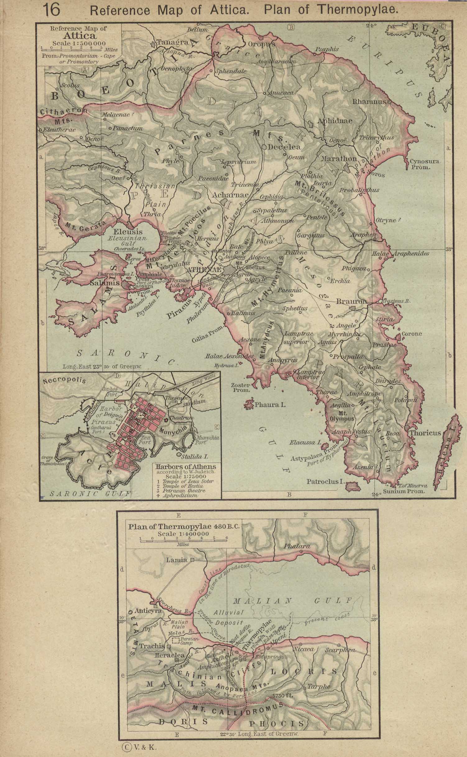
A division of Greece, in the form of a triangle, two sides of
which are washed by the Aegean Sea, while the third is separated from Boeotia
on the north by the mountains Cithaeron and Parnes. Megaris, which bounds it on
the northwest, was formerly a part of Attica. In ancient times it was called Acte
and Actice, or the "coast-land" (akte), from which the later form, Attica,
is said to have been derived. According to tradition, it derived its name from
Atthis, the daughter of the mythical king Cranaus; and old-fashioned etymologists
found in it the root which appears in that of the goddess Athene. Attica is divided
by many ancient writers into three districts. (1) The Highlands, the northeast
of the country. (2) The Plain, the northwest of the country, including both the
plain round Athens and the plain round Eleusis, and extending south to the promontory
Zoster. (3) The Seacoast District, the south part of the country, terminating
in the promontory Sunium. Besides these three divisions, we also read of (4) the
Midland District, still called Mesogia, an undulating plain in the middle of the
country. The soil of Attica is not very fertile. The greater part of it is not
adapted for growing corn; but it produces olives, figs, and grapes, especially
the two former, in great perfection. The country is dry; the chief river is the
Cephissus, rising in Parnes and flowing through the Athenian plain. The abundance
of wild flowers in the country made the honey of Mount Hymettus very celebrated
in antiquity. Excellent marble was obtained from the quarries of Pentelicus, northeast
of Athens, and a considerable supply of silver from the mines of Laurium near
Sunium. The territory of Attica, including the island of Salamis, which belonged
to it, contained between 700 and 800 square miles; and the population in its flourishing
period was probably about 500,000, of which nearly four fifths were slaves.
Attica is said to have been originally inhabited by Pelasgians.
Its most ancient political division was into twelve independent States, attributed
to Cecrops, who, according to some legends, came from Egypt. Subsequently Ion,
the grandson of Hellen, divided the people into four tribes, Geleoutes, Hopletes,
Argades, and Aegicores; and Theseus, who united the twelve independent States
of Attica into one political body and made Athens the capital, again divided the
nation into three classes, the Eupatridae, Geomori, and Demiurgi. Clisthenes (B.C.
510) abolished the old tribes and created ten new ones, according to a geographical
division; these tribes were subdivided into demes or townships.
This text is cited Oct 2002 from The Perseus Project URL below, which contains interesting hyperlinks
Attica, one of the political divisions of Greece.
I. Name.
The name of Attica is probably derived from Acte (Akte), as being
a projecting peninsula, in the same manner as the peninsula of Mt. Athos was also
called Acte. Attica would thus be a corruption of Actica (Aktike), which would
be regularly formed from Acte. It is stated by several ancient writers that the
country was originally called Acte. (Strab. ix. p. 391; Steph. B. s. v. Akte;
Plin. iv, 7. s. 11.) Its name, however, was usually derived by the ancient writers
from the autochthon Actaeus or Actaeon, or from Atthis, daughter of Cranaus, who
is represented as the second king of Athens. (Paus. i. 2. § 6; Strab. ix. p. 397;
Apollod. iii. 14. § 5.) Some modern scholars think that Attica has nothing to
do with the word Acte, but contains the root Att or Ath, which we see in Ath-enae.
II. Natural Divisions.
Attica is in the form of a triangle, having two of its sides washed
by the sea, and its base united to the land. It was bounded on the east by the
Aegaean sea, on the west by Megaris
and the Saronic gulf, and
on the north by Boeotia.
It is separated from Boeotia by a range of lofty, and in most places inaccessible,
mountains, which extend from the Corinthian
gulf to the channel of Euboea.
The most important part of this range, immediately south of Thebes
and Plataeae, and near the
Corinthian gulf, was called Cithaeron.
From the latter there were two chief branches, one extending SW. through Megaris
under the name of the Oenean mountains, and terminating at the Scironian
rocks on the Saronic gulf; and the other, called Parnes,
running in a general easterly direction, and terminating on the sea coast above
the promontory Rhamnus. The
modern name of Parnes is Nozia; that of Cithaeron, or at least of its highest
point, is Elate, derived from its fir-trees. These two chains of mountains, together
with the central one of Cithaeron, completely protect the peninsula of Attica
from the rest of Greece. It thus appears that Megaris naturally forms a part of
the peninsula: it was one of the four ancient divisions of Attica, but was afterwards
separated from it.
There are two passes across the mountains from Corinth
into the Megaris, which are spoken of under MEGARA.
Through the range of Cithaeron and Parnes there are three principal passes, all
of which were of great importance in ancient times for the protection of Attica
on the side of Boeotia. The most westerly of these passes was the one through
which the road ran from Thebes and Plataeae to Eleusis;
the central one was the pass of Phyle, through which was the direct road from
Thebes to Athens; and the eastern one was the pass of Deceleia, leading from Athens
to Oropus and Delium.
A more particular account of these important passes is given at the places Oenoe,
Phyle and Deceleia.
The highest points of Mt. Parnes lie between the passes of Phyle and Deceleia.
From this range of mountains there descend several other ranges into
the interior, between which there lie four plains of greater or less extent.
On the NW. boundary of Attica a range of mountains runs down to the
south, terminating on the west side of the bay of Eleusis in two summits, formerly
called Cerata (ta Kerata, Strab. ix. p. 395) or the Horns, now Kandili: this range
forms the boundary between Attica and Megaris. Another mountain range, extending
from Parnes to the south, terminates on the eastern side of the bay of Eleusis,
and at the narrow strait which separates the island of Salamis from the mainland:
it bore the general name of Aegaleos,
and parts of it were also called Poecilum
and Corydallus. Between the range of Cerata and that of Aegaleos lies the Eleusinian
and Thriasian Plain.
Eastward of this plain lies the Athenian Plain, frequently called
simply The Plain (to Pedion). It is bounded on the west by Aegaleos, as has been
already mentioned. Through this range of mountains there is an important pass
leading from the Eleusinian into the Athenian plain. It is a narrow rocky opening
between Mt. Corydallus, and is now called the pass of Dhafni: through it the Sacred
Way from Eleusis to Athens formerly ran. Further north, towards Acharnae,
are some openings in the heights, where are found ruins of a rampart, seven feet
high, and five feet and a half thick, built along the crest of the hills: the
summit of the wall forms a commanding platform towards the Eleusinian plain. (Leake,
p. 143.) On the west the Athenian plain is bounded by a range of mountains, which
also descends from Parnes. The northern part of this range appears to have been
anciently called Brilessus (Thuc. ii. 23), and subsequently Pentelicus
(to Pentelikon oros, Paus. i. 32. § 1; Mons Pentelensis, Vitruv. ii. 8), now Mendeli
or Penteli. The first Greek writer who applies the name of Pentelicus to this
mountain is Pausanias; but as Strabo (ix. p. 399) speaks of Pentelic marble, we
may infer with Leake that the celebrity of the marble quarried in the demus of
Pentele, upon the side of Mt. Brilessus, had caused the name of Pentelicus to
supplant that of the ancient Brilessus. The plain of Athens is bounded on the
south-east by the lofty range of Mt.
Hymettus, which is separated from that of Pentelicus by a depression about
two miles in length. Hymettus, the highest point of which is 3506 feet, is separated
by a remarkable break into two parts, the northern or greater Hymettus, now called
Telo-Vuni, and the southern or lesser Hymettus, which formerly bore also the name
of Anhydrus (Anudros, Theophr. de Sign. Pluv. p. 419, Heins.) or the Waterless,
now called Mavro-Vuni. The latter terminates in the promontory Zoster.
The hill of Lycabettus,
in the neighbourhood of Athens.
Sometimes both the Eleusinian and Athenian plains are included under
the general name of The Plain; and the coast of these two plains was more specifically
called Acte. (Strab. ix. p. 391.)
North east of the Athenian plain, between Parnes, Pentelicus, and
the sea, is a mountain district, known by the name of Diacria (Diakria) in antiquity.
Its inhabitants, usually called Diacreis or Diacrii (Diakreis, Diakrioi), were
sometimes also termed Hyperacrii Huperakrioi, Herod. i. 59), apparently from their
dwelling on the other side of the mountain from the city. The only level part
of this district is the small plain of Marathon,
open to the sea. At the north-eastern extremity of this district, west of Cape
Kalamo, there rises an eminence 2038 feet in height, which is probably the ancient
Phelleus (Phelleus), a name which came to be used by the Athenians for any rocky
heights adapted for the pasture of goats. (Aristoph. Nab. 71, Acharn. 272; Isaeus,
de Ciron. Hered. p. 227, Reiske; Harpocrat., Suid., s. v. Phellea; Hesych. s.
v. Phellos.)
South-east of the Athenian plain is an undulating district, anciently
called Mesogaea (Mesogaia) or the Midland district, and now Mesoghia. It is bounded
by Pentelicus on the north, Hymettus on the west, the sea on the east, and the
hills of Paralia on the south.
Paralia or Paralus (Paralia, Parakos), i. e. the Sea-coast district,
included the whole of the south of Attica, extending from the promontory Zoster
on the west, and from Brauron
on the east, to Sunium. It
was a hilly and barren district, but contained the rich silver-mines of Laurium.
(Thuc. ii. 55; Steph. B., Suid. s. v.)
It appears, then, that Attica is distributed into five natural divisions. 1. The Eleusinian or Thriasian Plain. 2. The Athenian Plain. 3. The Diacria or Highlands, including the Plain of Marathon. 4. The Mesogaea or Midland District. 5. The Paralia or Sea-coast District. This geographical distribution gave rise also to political divisions, as we shall see presently.
The small plain of Oropus, lying north of Parnes upon the Euboean
channel, generally belonged to Attica, though physically separated from it, and
properly a part of Boeotia. The area of Attica is about 700 square miles, not
including the island of Salamis, which is about 40 more. The length of the west
coast from Cerata or the Horns to Sunium is about 60 miles, and the length of
the east coast is about the same.
III. Rivers.
The rivers of Attica are little better than mountain torrents, almost
dry in summer, and only full in winter, or after heavy rains. The Athenian plain
is watered by two rivers, the Cephissus
and the Ilissus. The Cephissus
(Kephissos), which is the more important of the two, flows southwards from Mt.
Parnes on the west side of Athens, and after crossing the Long Walls falls into
the Phaleric bay. Strabo
(x. p. 400) places its sources at Trinemii. Leake observes: The most distant sources
of the river are on the western side of Mt. Pentelicus, and the southern side
of Mt. Parnes, and in the intermediate ridge which unites them; but particularly
at Kivisia, at the foot of Pentelicus,--near
Fasidhero, in the part of Diacria adjoining to the same mountain,--at Tatoy,
near the ancient Deceleia, and in the steepest part of Mt. Parnes, from whence
descends a broad torrent, which, passing near the village Menidhi,
pours a large occasional supply into the main channel of the Cephissus. Strabo
says that the Cephissus is only a torrent stream, and that in summer it fails
altogether; but this is not in accordance with the account of most modern travellers,
who represent it as the only river in Attica which is supplied with water during
the whole year. In ancient times it flowed in a single channel, and was probably
carefully embanked: it is now allowed to find its way through the olive-groves
in several streams, from which there are many smaller derivations, for the purpose
of watering olive-trees and gardens.
The Ilissus (Ilissos) is a more insignificant river. It was composed
of two branches, one of which was named Eridanus (Eridanos, Paus. i. 19. § 5).
The main branch rises at the northern extremity of Hymettus, and receives near
the Lyceium, on the east side of Athens, the Eridanus, which rises on the western
slope of Hymettus at a spot called Syriani. The united stream then flows through
the southern portion of the city, towards the Phaleric bay; but it scarcely ever
reaches the sea, and in the neighbourhood of Athens it is always dry in the summer.
The spreading plane trees, and the shady banks of this stream, which have been
immortalized by the beautiful description in the Phaedrus of Plato, have been
succeeded by sun-burnt rocks and stunted bushes. (Dodwell, vol. i. p. 475.) The
source of the river at Syriani is a beautiful spot, and is apparently described
in the passage of Ovid (Ar. Am. iii. 687), beginning:
"Est prope purpureos colles florentis Hymetti / Fons sacer, et viridi cespite
mollis humus."
There was a torrent in the Athenian plain called Cycloborus (Kukloboros),
described as rushing down with a great noise (Aristoph. Equit. 137, with Schol.,
Acharn. 381; Hesych., Suid.): it is probably the large and deep channel, called
Megalo Potamo, which descends from Parnes, and flows some miles, until lost in
the olive-groves. (Dodwell, vol. i. p. 477.)
Two small streams water the Eleusinian plain; one called the Cephissus
(Sarandaforo), rises in Mt. Cithaeron, and traverses the narrow plain of Eleutherae,
before it descends into that of Eleusis (Paus. i. 28. § 5); the other, now named
Ianula, has its origin in the range of Parnes, near Phyle. A small stream called
lapis (Iapis) formed the boundary between the territory of Eleusis and Megaris.
(Scylax, s. v. Megara; Callim. ap. Steph. B. s. v. Iapis.)
The only other rivulets of Attica deserving notice are three on the
eastern coast: one flowing through the plain of Marathon; a second rising on the
south-eastern side of Pentelicus, and flowing into the sea a little, below Rafina;
and a third, now called the river of Vraona, which descends from Hymettus, and
flows into the bay of Livadhi: the last is probably the ancient Erasinus (Erasinos:
Strab. viii. p. 371).
IV. Products.
The mountains of Attica are chiefly calcareous. The best marble was
obtained from Mt. Pentelicus, which supplied inexhaustible materials for the public
buildings and statues of Athens. The Pentelic marble is of a dazzling white colour,
hard, and fine-grained; but, owing to the little pieces of quartz or flint imbedded
in it, not easy to work. Hymettus also produced fine marble: it is not so brilliantly
white as the Pentelic, and in some places is almost grey. It was much used by
the Romans in architecture. (Trabes Hymettiae, Hor. Carm. ii. 18. 3.) Blue or
black marble, which was frequently used in the Athenian architecture, is found
at Eleusis, and was also obtained from a quarry near the promontory of Amphiale.
(Strab. ix. p. 395.) Marble was an article of export from Attica. (Xen. de Vect.
1 § 4.) Between Pentelicus and Parnes, the mass of rocks appears to have been
mica slate, which is also the basis of Pentelicus. Near the Horns, on the boundaries
of Megaris, there is a large deposit of conchiferous limestone, which Pausanias
mentions (i. 44. § 6).
The hilly district of Laurium, above the promontory of Sunium, contained
valuable silver mines, which contributed to raise Athens at an early period to
a foremost rank among the Grecian states. These mines require a separate notice.
(see Laurium)
The soil of Attica is light and dry, and produces at present little
wheat. In antiquity, however, agriculture was held in great honour by the Athenians,
who cultivated their land with extraordinary care. Some remarks are made elsewhere
(Athenae)
respecting the quantity of corn probably grown in Attica in ancient times.
The soil is better adapted for the growth of fruits. The olives and
figs were particularly delicious; they both ripened earlier and continued longer
in-season than those in other countries. (Xen. de Vect. 1) The olive-tree was
regarded as the gift of Athena, and its cultivation was always under the especial
care and protection of the goddess. From the olive-tree which grew in the temple
of the goddess on the Acropolis, there came the Moriae (moriai), or sacred olive-trees
in the Academy; and from these again all the other olive-trees, which grew in
the precincts of the temples and the grounds of private persons. Even in the present
day there are extensive groves of olive-trees along the banks of the Cephissus.
The fig-tree was under the protection of Demeter, as the olive was under the care
of Athena. Like the sacred olive-tree on the Acropolis, there was a sacred fig-tree
at Eleusis, which the goddess Demeter is said to have produced. Olives were exported
from Attica, and so probably were figs also; for the law which is said to have
prohibited the exportation of the latter became obsolete in historical times,
if indeed it ever existed. (Bockh, Publ. Economy of Athens, p. 41, 2nd ed.)
The wine of Attica was pleasant to the taste, though not of a superior
kind. The most celebrated was grown at Icaria,
where Dionysus is said to have been welcomed. One of the varieties of the Attic
grape was called the Nicostratian (Nikostratios Botrus, Athen. xiv. p. 654.) The
honey, however, was particularly fine, especially from the bees which sucked the
wild flowers of Mt. Hymettus.
Attica is not adapted for the breeding of horses to any extent; the
country is too hilly, and the soil too poor to afford much nourishment for them.
Hence they were very scarce in early times, and even at later times could be kept
only by the wealthy. For the same reason horned cattle were also scarce, and Philochorus
mentions an ancient law which prohibited the killing of these animals. (Athen.
ix. p. 375.) The slopes of the mountains, however, afforded excellent pasture
for sheep and goats, which were very numerous in ancient times. Goats in particular
formed a large portion of the wealth of the ancient inhabitants; and, from this
animal, one of the four ancient tribes was called Aegicoreis. Of sheep there were
several different breeds, particularly of the finest kinds. (Dem. c. Euery. et
Mnesib. p. 1153; Athen. xii. p. 540.) To encourage the breeding of sheep, there
was an ancient law, which forbade the sacrifice of a sheep until it had lambed
or had been shorn. (Athen. ix. p. 375.) The seas around the coast abounded in
fish, which were a favourite article of diet among the Athenians. Leake enumerates
several varieties caught in the Phaleric bay, of which the aphue, probably a sort
of anchovy or sardine, is often mentioned. Off Cape Zoster was caught the red
mullet (trigle).
On the mountains wild animals were found. Even in the time of Pausanias
the bear and the wild boar were hunted on Mt. Parnes. (Pans. i. 32. § 1.)
V. Political Divisions.
The oldest political division of Attica is said to have been made
by Cecrops, who divided the country into twelve independent communities, which
were afterwards united into one state by Theseus. The names of these communities
were: Cecropia, Tetrapolis, Epacria, Deceleia, Eleusis, Aphidna, Thoricus, Brauron,
Cytherus, Sphettus, Cephisia, and Phalerus. (Philochor. ap. Strab. ix. p. 397;
Etymol. M. s. v. Epakria; Plut. Thes. 24.) Their position has been ably discussed
by Finlay, in the Transactions of the Royal Society of Literature (vol. iii. p.
396), but as we shall have occasion to speak of each presently, it is only necessary
to state now that these names continued to exist down to the latest times of Athenian
history; that Cecropia became the Acropolis of Athens; that Tetrapolis contained
the four demi of Oenoe, Marathon, Tricory-thus, and Probalinthus (Strab. viii.
p. 383); and that the remaining cities sunk into demi.
Another ancient division of Attica into four parts, among the sons
of Pandion, has a distinct reference to the physical divisions of the country.
Nisus received Megaris; Aegeus the Coastland (akte), with the capital and the
adjoining plain (pedias); and the two other brothers Diacria (diakria), or the
Highlands in the NE. of the country, and Paralia (paralia), or the southern coast.
(Strab. ix. p. 392; Schol. ad Aristoph. Vesp. 1223, and ad Vesp. 58.) That this
division has a reference to some historical fact, is clear from the circumstance
that, after Megaris had been torn away from Athens by the Dorians, the inhabitants
of the remaining parts formed three political parties in the time of Solon and
Peisistratus, known by the name of the Men of the Plain, the Parali, and the Diacrii
or Hyperacrii. (Herod. i. 59; Plut. Sol. 13.)
Another division of the people of Attica into four (phulai or tribes,
existed from the earliest times. These tribes were called by different names at
different periods. In the time of Cecrops they were called Cecropis, Autochthon,
Actaea, and Paralia, the two former names being derived from mythical persons,
and the two latter from the physical divisions of the country. In the reign of
Cranaus, these names were changed into Cranais, Atthis, Mesogaea, and Diacris,
where again the two former are mythical, and the two latter local denominations.
Afterwards we find a new set of names, Dias, Athenais, Poseidonias, and Hephaestias,
evidently derived from the deities who were worshipped in the country. But these
names all disappeared before the four Ionic tribes of Geleontes, Hopletes, Argades,
and Aegicores, which continued to exist down to the time of Cleisthenes (B.C.
510). One of the most important measures in the democratical revolution, brought
about by Cleisthenes after the expulsion of the Peisistratidae, was the abolition
of the four ancient Ionic tribes, and the formation of ten new tribes. The names
of these ten tribes, derived from Attic heroes, were, in order of precedence,
Erechtheis, Aegeis, Pandionis, Leontis, Acamantis, Oeneis, Cecropis, Hippothoontis,
Aeantis, Antiochis.
This number remained unaltered down to B.C. 307, when it was increased to twelve
by the addition of two new tribes, Antigonias and Demetrias, in honour of Antigonus
and his son Demetrius, because the latter had delivered Athens from the rule of
Cassander. The name of Antigonias was subsequently changed into that of
Ptolemais, in honour of Ptolemy Philadelphus; and the Demetrias into Attalis,
when Attalus was the ally of Athens against Philip and the Rhodians. Finally,
the number of tribes was increased to thirteen, in the reign of Hadrian, by the
addition of Hadrianis, in honour of this emperor.
Each tribe was subdivided into a certain number of demoi, townships,
cantons, or parishes. The whole territory of Attica was parcelled out into these
demi, in one or other of which every Athenian citizen was enrolled. The number
of these demi is not ascertained: we only know that they were 174 in the time
of Polemo, who lived in the third century B.C. (Strab. ix. p. 396; Eustath. in
Il. ii. 546.) It has been supposed, from the words of Herodotus (deka de kai tous
demous kateneme es tas phulas, v. 69), that there were originally one hundred
demi, ten to each tribe; but it is improbable that the number of demi was increased
so largely as from 100 to 174, and hence some modern critics construe deka with
phulas, and not with demous, as the least difficulty in the case.
It is important to bear in mind that the demi assigned by Cleisthenes
to each tribe were in no case all adjacent to each other. The reason for this
arrangement cannot be better stated than in the words of Mr. Grote (vol. iv. p.
177): The tribe, as a whole, did not correspond with any continuous portion of
the territory, nor could it have any peculiar local interest, separate from the
entire community. Such systematic avoidance of the factions arising out of neighbourhood
will appear to have been more especially necessary, when we recollect that the
quarrels of the Parali, the Diacrii, the Pediaci, during the preceding century,
had all been generated from local feud, though doubtless artfully fomented by
individual ambition. Moreover, it was only by this same precaution that the local
predominance of the city, and the formation of a city-interest distinct from that
of the country, was obviated; which could hardly have failed to arise, had the
city itself constituted either one deme or one tribe. We know that five of the
city demi belonged to five different tribes: [p. 325] namely, the demus Cerameicus
belonged to the tribe Acamantis; Melite to the Cecropis; Collytus to the Aegeis;
Cydathenaeum to the Pandionis; Scambonidae to the Leontis. Moreover, Peiraeeus
belonged to the Hippothoontis, and Phalerum to the Aeantis.
For further information respecting the Athenian tribes in general,
and the organization of the demus, the reader is referred to the Diet. of Antiq.
arts. Tribus and Demus.
It is certain that the descendants of a man always remained in the
demus in which their ancestor was originally enrolled in the time of Cleisthenes.
Consequently, if a person transferred his abode to another demus, he was not enrolled
in the new demus in which he settled, even if he was highly esteemed by the inhabitants
of the latter, and had conferred great obligations upon them. This is clear from
an inscription in Bockh's collection (n. 101). (Sauppe, De Demis Urbanis Athenarum,
p. 13.) It is important to bear this fact in mind, because modern writers have
sometimes fixed the site of a demus, simply in consequence of finding upon the
spot the name of this demus attached to the name of a man; but this is not conclusive,
since the demus in which a man was enrolled, and the demus in which he resided,
might be, and frequently were, different.
Each of the larger demi contained a town or village; but several of
the smaller demi possessed apparently only a common temple or place of assembly,
the houses of the community being scattered over the district, as in many of our
country parishes. The names of most of the demi are preserved. It was the practice
in all public documents to add to the name of a person the name of the district
to which he belonged; and hence we find in inscriptions the names of a great number
of demi. Many others are met with in Harpocration, Hesychius, Stephanus, and Suidas,
as well as in the earlier writers. But though the names of most of the demi are
thus preserved, it is impossible to fix the site of a large number of them, as
they were not of sufficient importance to be mentioned in history. We shall endeavour,
however, to ascertain their position as far as is practicable, arranging the demi
under: 1. The Demi of the Athenian Plain. 2. The Demi of the Eleusinian Plain.
3. The Demi of Diacria and Mount Parnes. 4. The Demi of Paralia and Mesogaea.
A. THE DEMI OF THE ATHENIAN PLAIN.
The demi in the city of Athens and its suburbs:
1-10. Cerameicus, Melite, Scambonidae, Collytus, Cydathenaeum,
Diomeia, Coele, and perhaps Ceiriadae. To these must be added
Peiraeus and Phalerum.
(a.) West of the Cephissus in the direction from N. to S. were:
11. Xypete, 12. Thymoetadae, 13. Echelidae, 14. Corydallus, 15.
Hermus, 16. Oea or Oe, 17. Oeum Cerameicum, 18. Scirum, 19.
Laciadae, 20. Colonus
(c.) Farther north:
21. Acharnae, 22. Eupyridae, 23. Cropia, 24. Peleces, 25. Paeonidae,
26. Leipsydrium, 27. Cephisia, 28. Athmonum, 29. Iphistiadea, 30. Eiresidae,
31. Pentele, 32. Pallene, 33. Gargettus, 34. Agnus.
(d.) East of Athens:
35. Alopece, 36-37. Agryle (was the name of two demi, 38. Halimous,
39. Halae Aexonides.
B. THE ELEUSINIAN OR THRIASIAN PLAIN.
The celebrated Sacred Way (Hiera Hodos), leading from Athens to Eleusis,
demands a few words. It was the road along which the solemn procession in the
Eleusinian festival travelled every year from Athens to Eleusis. It was lined
on either side with numerous monuments. (Dict. of Ant. s. v. Eleusinia.) This
road, with its monuments, is described [p. 328] at some length by Pausanias (i.
36--38), and was the subject of a special work by Polemon, which is unfortunately
lost. (Harpocrat. s. v. Hiera Hooos.)
It has been mentioned elsewhere, that there were probably two roads
leading from Athens, to each of which the name of the Sacred Way was given, one
issuing from the gate called Dipylum, and the other from the Sacred Gate, and
that these two roads united shortly after quitting Athens, and formed the one
Sacred Way.
Pausanias, in his journey along the Sacred Way, left Athens by Dipylum.
The first monument, which was immediately outside this gate, was that of the herald
Anthemocritus. Next came the tomb of Molossus, and then the place Scirum. After
some monuments mentioned by Pausanias there was the demus Laciadae, and shortly
afterwards the Cephissus was crossed by a bridge, which Pausanias has omitted
to mention, but which is celebrated as the place at which the initiated assailed
passengers with vulgar abuse and raillery, hence called gephurismoi. (Strab. ix.
p. 400; Suid. s. v. Gephurizon; Hesych. s. v. Gephuristai.) After crossing the
Cephissus, Pausanias describes several other monuments, of which he specifies
two as the most remarkable for magnitude and ornament, one of a Rhodian who dwelt
at Athens, and the other built by Harpalus in honour of his wife Pythionice. The
latter, as we have already seen, was situated at the demus Hermus.
The next most important object on the road was the temple of Apollo
on Mount Poecilum, the site of which is now marked by a church of St. Elias. In
one of the walls of this church there were formerly three fluted Ionic columns,
which were removed by the Earl of Elgin in 1801: the capitals of these columns,
a base, and a part of one of the shafts, are now in the British Museum. It was
situated in the principal pass between the Eleusinian and Thriasian plains. This
pass is now called Dhafni; at its summit is a convent of the same name. Beyond
the temple of Apollo was a temple of Aphrodite, of which the foundations are found
at a distance of less than a mile from Dhafni.
That these foundations are those of the ancient temple of Aphrodite appears from
the fact that doves of white marble have been discovered at the foot of the rocks,
and that in the inscriptions still visible under the niches the words Phile Aphroditei
may be read. This was the Philaeum or the temple of Phila Aphrodite, built by
one of the flatterers of Demetrius Poliorcetes in honour of his wife Phila (Athen.
vii. pp. 254, a. 255, c.); but Pausanias, whose pious feelings were shocked by
such a profanation, calls it simply a temple of Aphrodite. Pausanias says that
before the temple was a wall of rude stones worthy of observation, of which, according
to Leake, the remains may still be seen; the stones have an appearance of remote
antiquity, resembling the irregular masses of the walls of Tiryns.
At the bottom of the pass close to the sea were the Rheiti (Peitoi),
or salt-springs, which formed the boundaries of the Athenians and Eleusinians
at the time of the twelve cities. The same copious springs are still to be observed
at the foot of Mt. Aegaleos; but the water, instead of being permitted to take
its natural course to the sea, is now collected into an artificial reservoir,
formed by a stone wall towards the road. This work has been constructed for the
purpose of turning two mills, below which the two streams cross the Sacred Way
into the sea. (Leake.)
Half a mile beyond the Rheiti, where the road to Eleutherae branches
off to the right, was the Tomb of Strato, situated on the right-hand side of the
road. There are still ruins of this monument with an inscription, from which we
learn its object; but it is not mentioned by Pausanias. The Way then ran along
the low ground on the shore of the bay, crossed the Eleusinian Cephissus, and
shortly afterwards reached Eleusis. Leake found traces of the ancient causeway
in several places in the Eleusinian plain, but more recent travellers relate that
they have now disappeared.
40. Eleusis, 41. Thria, 42. Icaria, 43. Oenoe, 44. Eleutherae, not a demus.
45. Panactum, a fortress, also not a demus. 46. Melaenae, 47. Drymus, a fortress,
not a demus.
C. THE DEMI OF DIACRIA AND MOUNT PARNES.
48. Phyle, 49. Harma, a fortress, but not a demus, near Phyle. 50.
Chastieis, 51. Deceleia, 52. Oeum Deceleicum, 53. Sphendale, 54.
Oropus, 55. Psaphis, 56. Rhamnus.
58, 59, 60. Titacidae, Perrhidae and Hyrgonidae were probably all in the
neighbourhood of Aphidna. These three demi, together with Aphidna, are
said to have been removed from the Aeantis to another tribe. (Harpocr. s. v. Thurgonidai.)
Perrhidae is described as a demus in Aphidna (Hesych. Phavor. demos en Aphidnais);
and that Titacidae was in the same locality may be inferred from the story of the capture
of Aphidna by the Dioscuri in consequence of the treachery of Titacus. (Herod. ix. 73; Steph. s.
v. Titakidai.)
61. Tinemeia
62, 63, 64, 65. Marathon, Probalinthus, Tricorynthus and Oenoe, four demi situated
in the small plain open to the sea between Mt. Parnes and Mt. Pentelicus, originally
formed the Tetrapolis, one of the twelve ancient divisions of Attica. The whole
district was generally known under the name of Marathon, under which it is described
in this work.
66. Epacria, 67. Semachidae, 68. Plotheia
69, 70. Phegaea, the name of two demi of uncertain site.
71. Hecale, 72. Elaeus.
D. THE DEMI OF PARALIA AND MESOGAEA.
Mount Hymettus, which bounded the Athenian plain on the south, terminated
in the promontory of Zoster, opposite to which was a small island called Phaura).
At Zoster, upon the sea, stood four altars, sacred respectively to Athena, Apollo,
Artemis, and Leto; (Strab. ix. [p. 331] p. 398; Paus. i. 31. § 1; Steph. s. v.
Zoster.) The hill of Zoster terminates in three capes; that in the middle is a
low peninsula, which shelters in the west a deep inlet called Vuliasmeni. (Leake.)
The island Phaura is now called Fleva or Flega.
73. Anagyrus, 74. Cholleidae,
75. Thorae (Thorai), a little south of Anagyrus. (Strab. ix. p. 398; Harpocr.; Steph.; Etym. M.)
76, 77. Lampptra, the name of two demi, Upper Lamptra and Lower or Maritime
Lamptra
78. Aegilia, 79. Anaphlystus, 80. Azenia, 81. Sunium,
82. Thoricus
83, 84. Aulon and Maroneia, two small places of uncertain site, not demi, in the
mining district of Mt. Laurium.
85. Besa, 86. Amphitrope,
87, 88. Potamos or Potamoi, the name of two demi
89. Prasiae, 90. Steiria.
91. Brauron, one of the twelve ancient cities, but never mentioned as a demus.
92. Halae Araphenides, 93. Araphen, 94. Prospalta,
95. Myrrhinus, 96. Phlya.
97, 98. Paeania, divided into Upper and Lower Paeania.
99. Philaidaei, 100. Cephale, 101. Sphettus, 102. Cytherrus.
(The best works on the demi are by Leake, The Demi of Attica, London, 1841, 2nd
ed., and Ross, Die Demen von Attika, Halle, 1846; from both of which great assistance
has been derived in drawing up the preceding account. The other most important
works upon the topography of Attica are Grotefend, De Demis sive Pagis Atticae,
Gott. 1829; Finlay, in Transactions of the Royal Society of Literature, vol. iii.
p. 396, seq., and Remarks on the Topography of Oropia and Diacria, 12mo. Athens,
1838; K. O. Muller, art. Attika, in Ersch and, Gruber's Encyclopadie, vol. vi.,
translated by Lockhart, London, 1842; Wordsworth, Athens and Attica, London, 1836;
Kruse, Hellas, vol. ii.; Leake, Northern Greece, vol. ii.; Stuart's Antiquities;
and the Travels of Dodwell, Gell, Bronsted, Fiedler, and Mure.)
At the end of the following URL ther is analphabetical table-list of the demi
(Total 160), the first column contains the name of each demus; the second that
of the demotes; the third that of the tribe to which each demus belonged during
the time of the ten tribes; and the fourth that of the tribe when there were twelve
or thirteen tribes. Of the demi in this list, which have not been spoken of above,
the site is unknown.
This extract is from: Dictionary of Greek and Roman Geography (1854) (ed. William Smith, LLD). Cited August 2004 from The Perseus Project URL below, which contains interesting hyperlinks
Depending on the context, Athens may refer to the city of Athens proper,
exclusive of its suburbs such as Piraeus,
its main harbor, or the larger urbain area including such suburbs as Piraeus,
or the whole of Attica, the
territory of the “city-state”, in which most of its citizens would
live and own land, or even the whole of the Athenian empire that spread all through
the Mediterranean, grew and shrunk over the years. Thus, what were called citizens
of Athens, were in fact people living all through Attica,
not necessarily in the city of Athens itself, though they all had to go there
from time to time to accomplish their civic duties.
The organisation of Attica
in the time of Socrates and Plato was the result of a reform by Cleisthenes in
508. According to this organisation, all citizens of Attica
entitled to participate in the political institutions of Athens were divided in
ten “tribes” (phylai in Greek), named after ten eponym heroes chosen
by the oracle of Delphi from
a list of one hundred names. Attica
as a whole was divides into three areas: a peripheral zone along the coast (exclusive
of the costal area close to Athens), called Paralia; a central area called Mesogeia;
and a third one including Athens and its vicinity, called Asty, that is, the City
area (asty is the common name in Greek for an urban area as opposed to the countryside,
agros). Each tribe was made up of sections of each of these three areas, called
trittues in Greek, that is, “Thirds”.
These so-called trittues were further divided into “demes”
(demoi in Greek, corresponding in general to the various villages of Attica
and districts of Athens. Each citizen of Athens was called by the name of his
deme, as for instance “Socrates from Alopece”
and he had to register in the deme of his father to enjoy his political rights
as a citizen of Athens. He would stay a member of that deme even if he was no
longer living on its territory.
Aside from this “political” organisation, there remained
older groupings, such as “families” (gene in Greek) and “phratries”
(groups of people supposed to have a common ancestor), that played a mainly religious
role in Socrates and Plato's time.
Bernard Suzanne (page last updated 1998), ed.
This extract is cited July 2003 from the Plato and his dialogues URL below, which contains interesting hyperlinks.

Receive our daily Newsletter with all the latest updates on the Greek Travel industry.
Subscribe now!
