Listed 100 (total found 154) sub titles with search on: Sights for wider area of: "PELOPONNISOS Region GREECE" .
CHRYSSOVITSI (Settlement) FALANTHOS

FINIKI (Village) ASSOPOS
Is of exceptional natural beauty and rich vegetation, running water and magnificent view. It is a wonderful place for relaxation. Underneath today’s church shrine is believed to have been the "Secret School" of the area.

GARGALIANI (Small town) MESSINIA
It is a piney hillock on the north side of Gargaliani
with a fantastic view on the plain and the island Proti
with a radius from Pilos
to Filiatra. When the
sky is clear you can even see the islands Strofades
and Zante.
KARYES (Village) LAKEDEMONA
KALAMATA (Town) MESSINIA
Neoclassical building with three floors. In form it is pedimental
at roof height, with pilasters with capitals at the corners.
It was built in 1833 and served as the 1st Hellenic Gymnasion. In
1960, by decision of the Ministry of Education, it was decreed a historical monument
to be preserved. In 1990, it became the Town-hall.
KARYES (Village) LAKEDEMONA
NAFPLIO (Town) PELOPONNISOS
The first House of Parliament of the Hellenes, located at Syntagma square.
Neoclassical building with three floors. In form it is pedimental
at roof height, with pilasters with capitals at the corners. It was built in 1833
and served as the 1st Hellenic Gymnasion.
In 1960, by decision of the Ministry of Education, it was decreed
a historical monument to be preserved. In 1990, it became the Town-hall.
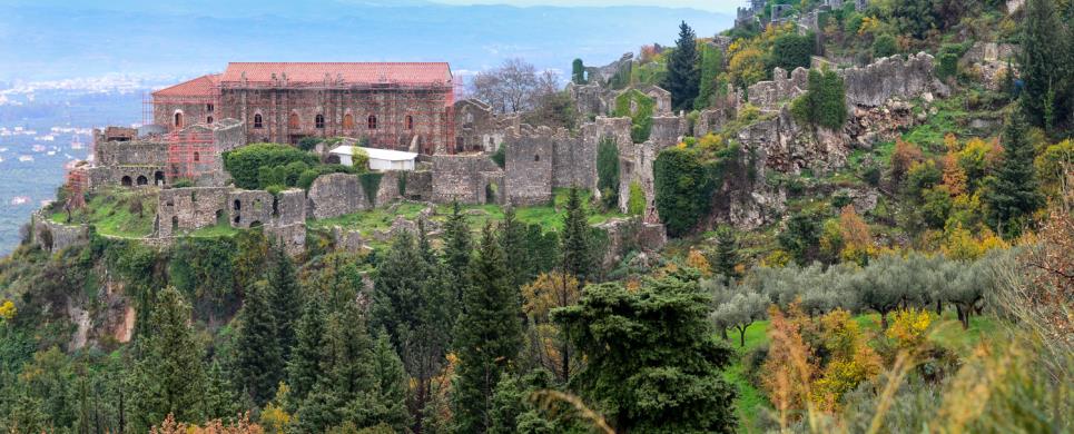
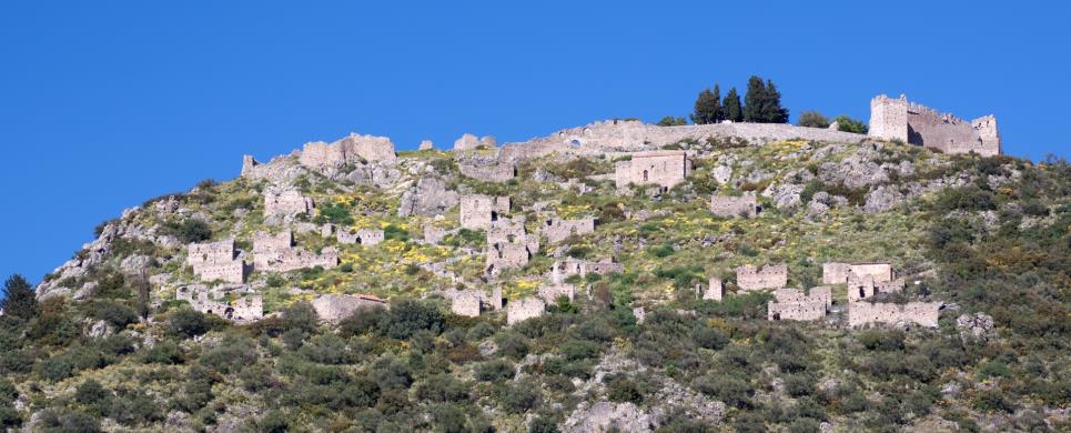
MYSTRAS (Byzantine settlement) PELOPONNISOS
Tel: +30 27310 83377, 23315
Fax: +30 27310 83377
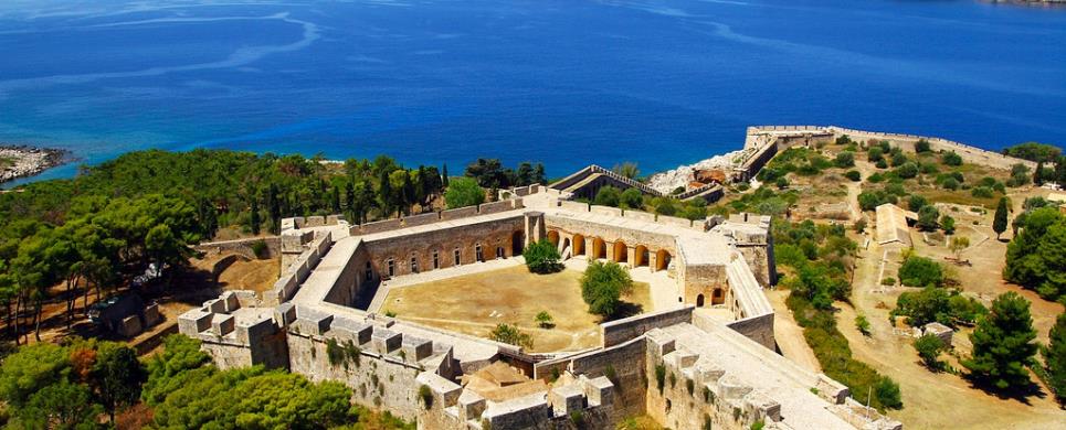
Like a replica in miniature of the majestic form of Mt. Taygetos, Mystras rises above the verdant valley of Eurotas. Historically, the medieval fortress town of Mystras moves to the forefront after the Fourth Crusade, in 1204, when the crusaders establish the Latin empire (1204-1261) and other states in the Byzantine lands they conquered. The region of the Peloponnese was occupied by the Frankish knights and hence became the Principality of Achaea under the reigning family of the Villehardouins. William II of Villehardouin fortified Mystras and built the castle on the top of the hill in order to subdue the unruly mountain dwellers of Taygetos and to secure the defence of the fertile Lacedaemon. The castle had barely been completed when the Prince of Achaea, defeated by the Byzantine emperor Michael VIII Palaeologus at the battle of Pelagonia and made prisoner in 1259, was forced to cede as ransom to the Byzantines the three strongholds of Peloponnese, among them Mystras.
Mystras soon evolved into a major centre of the Byzantine empire, second only to the capital Constantinople. It was in Mystras, actually, that the Byzantine art and literature flourished for the last time before the spread of the Ottoman conquests in the mid-15th century. As a cultural phenomenon, this creative flourishing in arts coupled with the revival of the classical letters and especially philosophy in Mystras was named by the scholars the Palaeologan Renaissance.
The first edifice to be raised at Mystra was the Villehardouin castle
on the summit of the cone-shaped hill. The outer wall begins to descend from the
north, follows the side of the hill until it reaches the foot, then turns right,
passing behind the Marmara restaurant, in the direction of the Peribleptos. At
frequent intervals the wall is fortified with high square towers.
The second line of defense, which begins at the Nauplia Gate, may
be discerned on the lofty ground where the Palace is situated. Following the contours
of the hill in an eastward direction, it then continues south as far as the Monastery
of the Pantanassa, after which it continues to descend as far as the level of
the Peribleptos. At this point, it turns west and, still following the contours
of the hill, climbs up to the level of the castle.
The hill on which Mystra is built was thus defended by two strongly
fortified walls, dominated by an impregnable castle. Within the lower and larger
enceinte, i.e. the lower city, dwelt the urban classes. Higher up, in the Upper
City, was situated the aristocratic quarter, with its palaces, mansions and government
offices.
Only two gateways led to the Upper City; the Monembassia Gate, with
towers, gun embrasures and an iron doorway; and the Nauplia Gate similarly fortified.
The whole fortification system is crowned by the Castle, which served
as an observation post in peace, as a last refuge in times of siege.
This text is cited Apr 2003 from the Laconian Professionals URL below, which contains image.
Mystras today is a silent town that lifts its ruins in the west side
of Taygetus, just above the
valley and the city of Sparta.
The Mystras is built at the base of the Parorion
Gorge within a dazzlingly beautiful landscape. It was established in 1249 by the
Francs and is an excellent example of a Byzantine city dated between the 14th
and 15th century. Although it was founded by the Francs, it soon came under Byzantine
Rule and began to gradually develop resulting in its transformation into a prosperous
city occupied by 20.000 inhabitants. In the year 1348, it became the seat of the
Despotate of Moreas. It comprised one of the last significant spiritual institutions
of the Byzantine in light of the fact that it constituted a point of attraction
that enticed intellectuals and artists from Constantinople
and Europe. The Mystras' ruins are divided into three sections: 1) the Castle,
the primary fortification on the hill's peak, 2) the Upper City, which contains
homes and narrow roads surrounding the Bishop's Palace that was surrounded by
bastions and 3) the Lower City, which contains homes and monasteries safely protected
behind the third wall.
The most significant Mystras' architectural works in their entirety
include:
•The Cathedral, which also constitutes the oldest church of Mystras,
is dedicated in honor of St. Demetrios and is located at the gate near the Lower
City. The Cathedral's wall paintings belong to three different religious painting
schools and were discovered by G. Mille in 1896, since the subsequent people that
followed covered the wall with asbestos. There is also an engraved throne with
Baroque carvings that must have been constructed under Venetian Rule. The floor
of the middle aisle contains a sculpted slab that depicts a two-headed eagle.
It is said that in 1449, Constantinos Paleologos was crowned Emperor here.
•The Monastery of Vrontohiou was the spiritual center of the Mystras
Town. The philosopher George Gemistos or Plithon (1355 - 1452) taught at this
Monastery. The complex consists of the churches Panagias tis Hodegetreas, that
is, the Virgin Mary, Leader of the Way ("Proprietor") and the church of Saints
Theodore.
•The church of Our Lady Perivleptos is located on the southeastern
point of the exterior wall. It is two-columned, cruciform and maintains a small
dome that illustrates the Pantocrator including the Virgin Mary and prophets.
It is founded upon a cave-like cliff. There is also the reflection of an unknown,
noble couple that appears to have built the church in the early 14th century.
The small chapel of St. Ekaterini is found within the cave. It is said that it
comprised the Elefsinion cave that was commemorated by Pausanias. The wall paintings'
artwork is considered to be a forerunner in the "Cretan" technique and is a masterpiece,
particularly in the figures that are filled with life and the elegance in their
movements. There is even a peculiar sculpted slab in which Alexander the Great
is depicted ascending into the heavens, assisted by two greedy birds. Visitors
will even notice the strong tower with the bastions that bring to mind the Italian
architecture, as it rises above the table.
•The Monastery of Our Lady Pantanassa (the Queen of All) was built
in 1428 by Theodore Paleologos II master builder and is located at the mouth of
the cliff on the east side of the hill. It is the most well preserved monument
in Mystras. It comprises a luminous example of the architecture evident at the
time. The wall paintings are remarkable whilst the view of the Evrota
Valley from the Monastery is breathtaking. The visitors are ecstatic as they absorb
the landscape at their feet and rest from Mystras' uphill trail.
•The palaces of Mystras' bishops are massive structures that are shaped
in the form of the Greek letter "G", that is, Gamma. Each building maintains its
own use and they are each comprised of two aisles, which have been renovated recently.
Egemon's grand Throne Room is located here. The courtyard in front of the palaces
was used for public assemblies during the period of the Byzantine Empire whilst
it was used as an agora or market under the Turkish Empire. The illiterate wanderers
of the Turkish Empire describe these structures as the "Sanctuary of Menelaos"
and the common tradition refers to them as the "Princess' Palaces." The Throne
Room is worth visiting with the Gothic windows and skylight. There are also the
ruins from 2.000 noble homes as well as churches, towers and palaces, which exemplify
life in those days.
•The Castle was built in 1249 and still maintains its original scheme
even though it later undergoes many changes. It is located at the peak of the
Upper City and surrounded by sudden trenches on its west and east sides that served
to protect the structure. It may be accessed only from the path that leads from
the entrance located above the Church of St. Sophia. A secondary interior wall
surrounds the highest section of the Castle. The door opens under the protection
of a tall tower constructed, as was the Gate, by the Byzantines. The exterior
surrounding wall leads to a platform above a cistern and a circular bastion. A
tower extends above the shelter, a great majority of which has been demolished,
that the Francs built above a cistern.
This text is cited May 2003 from the Hellenic Ministry of Foreign Affairs URL below.
ASTROS (Port) ARCADIA
Tel: +30 27550 22901
The castle located on the south summit of the hill called "Nissi" was built in
the Medieval period and was later remodelled as a strong defensive complex. In
the 18th century, the three Zapheiropoulos brothers, merchants living abroad,
returned to their home town to fight for the Greek revolution and built their
houses inside the caslte.
The most important monuments on the site are:
The Castle: It is rectangular in plan, with careless wall masonry. A large part of the enceinte
and one of the defensive towers are preserved today.
Panos Zapheiropoulos residence (inside the Castle): The rectangular building is erected on the ruins of an earlier building, of unknown date. The interior was divided by wooden
partition walls.
Constantinos Zapheiropoulos residence: It contains four compartments attached to the south wall of the castle and had auxiliary rooms, a latrine, and cisterns.
Ioannes Zapheiropoulos residence: It is preserved in bad condition but the whole structure is similar to Constantinos Zapheiropoulos' residence. Ruins of many more buildings of unknown
function and date are preserved inside the castle.
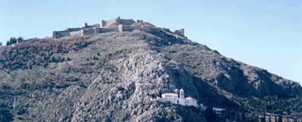
GERAKI (Small town) LACONIA
Tel: +30 27310 71329
The
castle is built on a low hill, at the southwest slopes of mount Parnon, near
the village of Geraki. It was founded in 1209 by the Frankish baron Guy de Nivelet
and remained under Frankish occupation until 1259. After the Franks were defeated
in the battle of Pelagonia in 1259, the castle was given over to the Greeks in
1262 and supported the Despotate of Mystras (1262-1460).
The church of St. George and remains of urban buildings are preserved inside the
castle, while ruins of buildings and churches have survived outside the fortified
area. At the end of the 17th century the castle was captured by the Venetians,
in 1715 was occupied by the Turks, and was finally abandoned at the end of the
18th century.
For many years the 5th Ephorate of Byzantine Antiquities has been conducting restoration
work on the monuments of Geraki. Work has been almost completed for the churches
and is currently progressing on the fortification walls and the secular buildings.
The wall paintings of the churches have also been restored. A large Early Christian
basilica was excavated by A. Xyngopoulos in the outskirts of the village of Geraki,
to the SW of the church of St. Athanassios. The apse of a second Early Christian
basilica has been located under the apse of the church of Saint Sozon.
The most important monuments on the site are:
Castle and remains of urban buildings inside and outside the fortification.
Monuments inside the castle are:
Church of St.
George. Three-aisled basilica with a narthex, decorated with wall paintings
dated to the 14th century.
Church of Our Lady Zoodochos Pighi (the Life-giving Source). Aisleless
church with wall paintings dated to the 15th century.
Church of St.
Paraskevi. Cross-vaulted church, decorated with wall paintings of the 15th
century.
"Pera Ecclesies" (Far Churches). Church of Prophet Elijah, aisleless, with
wall paintings dating from the 15th century; church of the Epiphany, cross-vaulted,
with wall paintings dating from the 13th century; church of the Taxiarches (the
Archangels), cross-vaulted, with wall paitnings dated to the 15th century.
Monuments in the modern settlement:
Church of Evangelistria (Our Lady of the Annunciation). Aisleless, cross-in-square
church, decorated with wall paintings of the 12-13th centuries.
Church of Saint
Sozon. Domed, four-column, cross-in-square church, probably built in the 12th
century. The interior is decorated with wall paintings dated to the 13th century.
Church of St. Athanassios. Domed, four-column, cross-in-square church,
probably built in the 12th century. The interior is decorated with wall paintings
dated to the 13th century.
Church of St. Nicholas. Two-aisled church, decorated with wall paintings
dating from the end of the 13th century.
Church of St. John Chrysostomos. Aisleless church with two layers of wall
paintings, dated to the end of the 13th-beginning of the 14th century, and the
middle of the 15th century.
GLYPPIA (Ancient small town) LEONIDION
KALAMATA (Town) MESSINIA
It is situated behind the north part of the church of the Candlemas of our Saviour and it is believed that it's where the Acropolis of the homeric (1580-1120 B.C) and classical Faron (palace of Ortilohos and later Diokles) was. The medieval castle was built by Godefredo Villeardouino in 1205 A.D. and underwent many alterations inconstruction and additions by its subsequent lords; the Byzantines of Mystras, the Turks and the Eneti of Morozini. The entrance is dominated by the lion of St. Mark, a sample of the Eneti era, while in and around the castle have been found ostraka (fragments) and remains of the Mycaenean and Roman years as well as tombs of the hellenistic and roman era. On the north side there is a small byzantine temple and it has been speculated that it was dedicated to the Blessed Virgin Mary the Kalomata, after which, according to some, Kalamata was named.
This text is cited March 2003 from the Messenia Prefecture Tourism Promotion Commission URL below, which contains image.
KORONI (Small town) MESSINIA
The castle of Koroni is erected in the south part of the city of Koroni.
In the classical years it was a simple, plain fort but it later became a byzantine
fort, which was conquered by the Franks(the French) of the 4th crusade in 1205.
With the treaty of the island of Sapientza (1209) it was given to Venetians, which
they turned into a fort for their port in order to promote their commercial products.
In August 1500, it is coquered by the Turks and many residers flee
for Zakynthos, Kefallonia and later for Lower Italy.
In 1532, the emperor of German and Spain, Charles the 5th, wanting
to create a distraction and provoke the sultan Souleiman the Magnificent, he
sends armed forces to the Peloponnese with the admiral Andrea Doria.
Doria's expedition was a failure and he had to leave Methoni in
1534 taking 2000 refugees from Koroni who settled in Lower Italy. The Venetians
come back (1685-1715) with Frank Morozini.
In 1715, the Turks come back and stay until 1828 turkish families
settle in the castle and both social and financial decay starts, which is completed
with the bombardment of Orlof (1770).
In 1828, it is liberated and given to the Greek goverment by the
French general Maizon with Nikitaras as commandant.
This castle is ruined today but, the old-calendar convent of holy
John the Baptist, the ruined Byzantine temple of St. Sophia, the church of St.
Haralambos and the «RESALTO», a place to honour the Greek fighters who tried
to conquer the castle in 1824, are preserved.
In addition, the hewn tombs, Venectian reservoirs, Turkish baths
and the magnificent «domes» are preserved. In every corner of the castle there
is a «dome», that is, a gunpowder storehouse or bizihanes, while the best «dome»
was blown up the Germans in 1944 during their withdrawal.
This text is cited Jan 2003 from the Messenia Prefecture Tourism Promotion Commission URL below, which contains image.
KYPARISSIA (Small town) MESSINIA
The castle which constituted the acropolis of ancient Kyparissia was built in the Upper Part of the Kyparissia and overlooked the blue endlessness of the Ionian sea as well as the tame valley. We don't know when it was built but the Lower Walls have been built according to the symmetrical style of fortification which constitutes a sign of mycaenaic style architecture, while during the Byzantine years, and under Justinian's ruling, the castle is restored and on the four corners, four turrets were built from which only the eastern one is saved. During the domination by the Franks(1205-1430 A.D) it was restored by the Franks and constitutes an impregnable fort for the flourishing city of Kyparissia while, during the Turkish rule, eminent Turks lived there and improved its infrastructure. Today, only a small amphitheater is saved where social functions take place.
This text is cited March 2003 from the Messenia Prefecture Tourism Promotion Commission URL below, which contains image.
LARISSA (Acropolis) ARGOS
Tel: +30 27510 22810
The
castle lies on the prominent hill called "Larissa", overlooking the town of
Argos. It was founded in the 6th century B.C. During the Byzantine period the
fortress was of essential strategic importance and in 1203 came under the control
of the archon of Nauplion, Leon Sgouros. In 1212 it was captured by Othon de la
Roche and was controlled by the Greeks until 1388. Between 1394 and 1463 it was
occupied by the Venetians. In 1463 it was captured by the Turks and remained under
their control until 1822, interrupted during 1686-1715, when Larissa came under
the control of the Venetian admiral Morozini. The site was liberated by the Greeks
in 1822.
Salvage interventions have been carried out at the foundations of
the monument. The exterior circuit wall and the entrance have been consolidated
by the 5th Ephorate of Byzantine Antiquities.
The most important monuments of the site are:
•The Castle.
The external horseshoe-shaped circuit wall has an entrance on the
SW side and is reinforced by battlements and toowers (square, round, triangular,
and octagonal). A second, interior enceinte to the south forms the smaller, upper
fortress. The main architectural phase of the monument dates from the Medieval
period but traces of earlier phases have also been distinguished.
•Small Byzantine church over the north wall of the interior fortress.
MAGOULIANA (Village) VYTINA
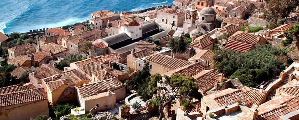
MONEMVASSIA (Village) LACONIA
Tel: +30 27320 61403
Fax: +30 27320 61403
Monemvasia occupies a steep, rocky islet connected to the Laconian
coast by a bridge. The
settlement was founded in the 6th century A.D. by the inhabitants of Laconia.
A second settlement was later founded on a lower level, and gradually developed
into a town of significant strategic importance. After a short domination of
the Popes, the area was captured by the Venetians in 1464. In 1540 it was occupied
by the Turks and its decline became more evident. In 1690 it was given over
to the Venetians and in 1715 was recaptured by the Turks. It was the first among
the fortified towns of the Peloponnese to be liberated by the Greeks in 1821.
The 5th Ephorate of Byzantine Antiquities has reconstructed the
demolished parts of walls in the Upper Town and has restored the church and
the wall paintings of Aghia Sophia. In the Lower Town, the sea wall has been
rebuilt, the Moslem Mosque has been restored, the east and west bastion of the
fortification wall have been consolidated, and many of the churches have been
repaired and restored.
The most important monuments of the site are:
The settlement
which is divided into two sections, built at different levels, each with a separate
fortification. Remains of numerous Byzantine and post-Byzantine buildings are
preserved in the area of the Upper Town which is not inhabited today. Church
of Aghia Sophia (Holy Wisdom) at the Upper Town. Octagonal, domed, cross-in-square
church, identified by some scholars as the Monastery of Our Lady Hodegetria,
dated to 1150.
Lower Town. The area is inhabited today and many of the ruined buildings
have been restored by the 5th Ephorate. The settlement is surrounded by a U-shaped
fortification wall with two gates, one on the east and one on the west side,
and a small exit to the sea. Important monuments of the Lower Town are:
Church of Christ
Helkomenos (Led to the Passion). Domed, three-aisled basilica with a barrel-vaulted
roof, a narthex, a built synthronon, and an episcopal throne. Significant portable
icons of the post-Byzantine period are preserved in the interior.
Moslem Mosque. It was built in the first period of the Turkish occupation (16th
century), was converted into a Frankish church during the Venetian occupation,
and again became a mosque in the 18th century. It has been restored and houses
the Archaeological Collection of Monemvasia.
Church of Panaghia
(Our Lady) Myrtidiotissa. Single-aisled, domed basilica built in ca. 1700.
The interior was decorated with a wooden carved screen.
Church of St.
Nicholas. Three-aisled basilica with a dome and a barrel-vaulted roof, built
in 1703.
Church of Panaghia (Our Lady) Chrysaphitissa. Square room roofed with
a low dome, built in the 17th century.
Many smaller churches are to be seen in the Lower Town of Monemvasia: St. Andrew,
St. Anne the Catholic, St. Anne, dated to the second Venetian occupation (1690-1720),
St. Demetrios and several more.
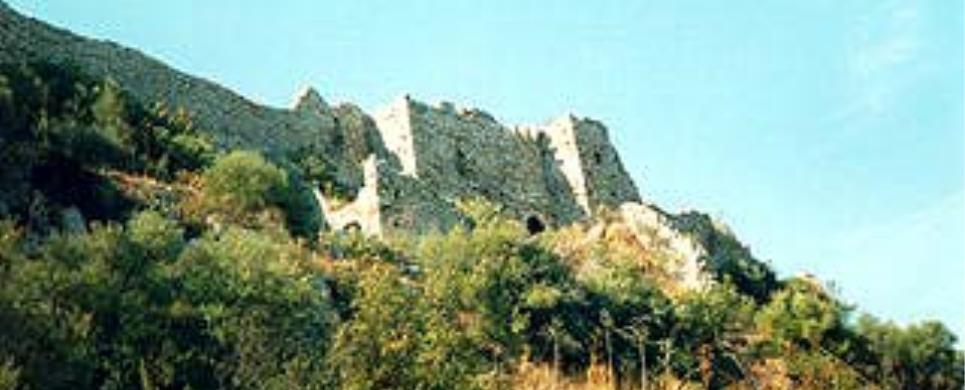
MYSTRAS (Byzantine settlement) PELOPONNISOS
The most important group of buildings associated with the city's defense
system are to be found within the Castle area. The wall with battlements and towers
was built in 1249 by the Franklin prince, William II de Villehardouin. Later,
it was repaired by Byzantines and Turks who also made additions to it. The main
entrance is protected by a large square tower.
Ruins of buildings erected during the Turkish occupation are scattered
about the entire declivity extending between the outer enceinte and the southern
section. A strong still fairly well preserved round tower rises on the north-east
side, near a large underground cistern which supplied the fortress with water
in times of siege. The tower formed part of the fortification system of the castle
and also served as a look-out post whence the movements of the population dwelling
on the slopes of Taygetos could be observed.
Both from this side of the hill and from the one overlooking Taygetos
the rocky eminence of Mystra rises sheer from the revine below and is thus rendered
impregnable at this point. Returning towards the tower, one encounters - just
before reaching the tower - the entrance which pierces the second line of defense,
and beyond which extends the highest and most inaccessible part of the castle.
The building with the underground cistern served ad the residence of successive
garrison commanders. A little higher up are the ruins of a twin chapel, one side
of which is embedded in the southern battlements of the fortification wall. This
little edifice, the oldest at Mystra, existed before the Frankish conquest and
the building of the castle. Still higher up, the west end of the ledge is crowned
by the ruins of another round tower with an observation post overlooking the opposite
slope of Taygetos, from which wild tribes of Melings, issuing out of their mountain
fastnesses, would make sudden hostile irruptions. The view from this part of the
castle is superbly impressive. In front extends the Lacedaemonian plain, across
which flows the Eurotas, with Sparta in the middle; to the west tower the savage
and grandiose contours of Taygetos; to the east the ruined city descends the hill,
dotted with the outlines of a variety of charming churches and the shells of ancient
mansions whose shattered masonry, pointing skywards, conjures up an image of human
hands raised in prayer.
This text is cited Apr 2003 from the Laconian Professionals URL below, which contains image.
NAFPLIO (Town) PELOPONNISOS
(Following URL information in Greek only)
NEA EPIDAVROS (Small town) ARGOLIS
The natural fortification offered security from invasions by pirates and from neighboring enemy hordes and later on from military units. In the Byzantine age supporting work was undergone on the castle to improve the wall construction. Afterwards, in circa 1205 AD, the Franks had control of the area. Then between 1463 and 1467 AD, the castle fell into the hands of Enetous. In the castle there were three churches, one to saint Theodosiou, one to The Madonna, and one to saint Ioannis of Theologou but only the last survives to this day.
NEAPOLI (Small town) PELOPONNISOS
NIOKASTRO (Castle) PYLOS
Tel: +30 27230 22955
Two castles are built on the summits of the two hills at the ends
of the Bay of
Navarino, overlooking the town of Pylos: the older castle of Navarino, called
Palaiokastron or Palaionavarinon and the more recent castle, called Niokastron.
The latter was built in 1573 by the Turks, and in 1686 was given over
to the Venetians. It again came under Turkish domination in 1715, along with the
castle of Koroni and Palaionavarino. In 1816 it was captured by Ibrahim Pasha
and remained under his control until 1828 when it was liberated by the French
general Maison. During the Second World War it was used as the seat of the Italian
and, later, the German headquarters.
Large-scale restoration work has been carried out for many years.
The restored hexagonal Fortress on the top of the hill houses the Museum and the Underwater Archaeological
Research Centre.
The most important monuments of the site are:
The
Castle.It is divided into two main sections:
- Enceinte-Lower Castle; the larger of the two sections occupies the slope of the hill and is built of ashlar limestone blocks.
- Upper Castle; hexagonal fortress with massive battlements and projecting bastions which protect five of the six corners of the walls.
Church of the Metamorphosis (Transfiguration). Cross-in-square domed church dedicated to the Transfiguration of Christ. It was used as a Moslem mosque and was later converted into a Christian church.
General Maison's building. Rectangular, two-storeyed stone
building erected in the 19th century. It has been reconstructed and now houses
the Museum and the offices.
The most important monuments and architectural totals are:
- The castle which is divided in two parts:
Compound-Lower castrle: The bigger of the two parts spreads on the slope of the hill and its perimeter is 1566 m. It takes up on area of 80.000 m2 and it's built with hewn limestone.
Upper castrle: An hexagonal fort with strong ramparts and projecting bastions which cover five out of its six corners.
- The church of the transformation of the Saviour; Cross-shaped church with a gothic-style dome which was built by the Franks. It functioned as a Muslim mosque first and subsequently as a Christian Church.
- General Mezon's building: Rectangular two-storey building, with stones of the early 19th century, in which, after its restoration, there is a museum and offices.
This text is cited Jan 2003 from the Messenia Prefecture Tourism Promotion Commission URL below, which contains image.
ORCHOMENOS (Village) LEVIDI
PALEOPYRGOS (Village) LEVIDI
PAPADIANIKA (Small town) ASSOPOS
Situated on the county road of Papadianika - Demonia. The ascent of it is of stone steps. There are also ruins of bulwark in that position. It was used as a refuge by the habitants to protect them selves from the invasions of pirates and Turks. It is characterized as an ideal place for all, but mostly for the outdoorsy who love walking. The view from Paleokastro is unique. One can descry: Glyfada, Boza, Asopos, Xili, Karavostasi, Plitra, Papadianika, Charakia, the Demonia beach (Pila), Archagelos, Githio, Kythira and generally all the Lakonesean Golf.
PORTO KAGIO (Port) ANATOLIKI MANI
METHONI (Small town) MESSINIA
The early christian cemetary - Byzantine Hermitage of St Onoufrios, which is carved
into the natural rock 3 km. north of Methoni close to the road going to Pylos.
The monument was excavated during August 1967 and the year 1968. It is a complex
of escavated chambers into the rock and open air graves. The area around the monument
has served during ancient and medieval times as a poros quarry his is where construcion
material for the building of the Castle of Methoni was used. To the east of the
monument and at a distance of 400 meters in the area called Agaki, lies another
equally important monument of the area, the Byzantine Temple of St. Bassileios.
The vistitor can visit the area easily, observe the monyments and enjoy the magnificent
view from the hill.
This text is cited March 2004 from the Municipality of Methoni URL below, which contains image.
On the Agios Nikolaos hill, 2km away from town.
AGIOS DIMITRIOS (Settlement) LEFKTRA
AGIOS GEORGIOS (Settlement) ITYLO
DIROS (Village) LACONIA
One of the most important caves internationally, since the archaeological
finds indicate that is was inhabited since at least 5300 B.C. It is new Vlihada,
to its east, and covers and area of 6,500 sq.m of which 600 sq.m. are land and
the remainder the passage of an underground river. It was discovered in 1958 and
explored by the Petrohilos couple. The average temperature is 10 C and that of
the water 18 C. The archaeological investigation of the cave begun in 1970 under
Giorgos Papathanasopoulos. It proved that the cave possessed fresh water springs
and had been inhabited in later Neolithic times (400-300 BC) as a shelter, residence,
workshop, storeroom,but also as a place of worship and entombing. The findings
are many, of a great variety and quality, indicating habitation by a large number
of people with commercial, maritime and farming interests. They include stone
implements, bone and obsidian, ceramics, weaving tools, jewelry, clay and marble
idols and human and animal skeletons. Alepotripa will be open to the public as
soon as the research and restoration work is completed. Visitors however can admire
the most impressive of the findings at the Neolithic Museum of Diros, at the entry
to Alepotripa.
This text is cited Oct 2002 from the Laconian Professionals URL below, which contains images.
Almost at sea-level, Vlihada is one of the most beautiful lacustrine
caves in the world. Its total area is 33,400 sq. m, of which corridors amounting
to 5,500 sq.m. have been explored.
Its existence was known since 1900, but it was first explored in 1950
by Ioannis Petrohilos. Further investigation has brought to light animal fossils
dating two million years.
The temperature in the interior varies between 16 and 20 C, and that
of the water is 12 C. Tours are by boat, and in one part by foot. A tour through
the lacustrine part (2.5klm) stays indelibly on the mind, as the boat glides between
dream-like formations of stalagmites and stalactites and their reflections upon
the water; pink and white chambers, hanging fairy-beds, and much, much more…
This text is cited Apr 2003 from the Laconian Professionals URL below, which contains images.
KALIANEIKA (Settlement) AVIA
MEGALI MADINIA (Village) AVIA
SCHIZA (Small island) INOUSSES
Στη Δυτική πλευρά της νήσου Σχίζας και σε απόσταση 400 μ από την θάλασσα, υπάρχει
ένα θαυμάσιο ανεξερεύνητο σπήλαιο γνωστό ως "Μαύρη Τρύπα". Το σπήλαιο
είναι διανοιγμένο μέσα σε Ηωκαινικό Παλαιοκαινικό ασβεστόλιθο. Η πορεία μέσα στο
σπήλαιο είναι πολύ δύσκολη. Εκεί που μπορεί να φτάσει ο παράτολμος εξερευνητής
είναι η αίθουσα, η οποία χωρίζεται σε μικρότερους θαλάμους. Το θέαμα των σταλακτιτών
και σταλαγμιτών είναι υπέροχο. Έχουν εντοπιστεί όστρακα προϊστορικών χρόνων. Το
σπήλαιο παρουσιάζει Αρχαιολογικό, Γεωλογικό και Τουριστικό ενδιαφέρον.
Το κείμενο παρατίθεται τον Μάρτιο 2004 από την ακόλουθη ιστοσελίδα του Δήμου Μεθώνης
SKYFIANIKA (Settlement) GYTHIO
EXOCHORI (Village) LEFKTRA
The forest of Vasiliki is in a natural «fortress» of Taygetos in the
west of the Messinia-Lakonia boundary and 6 km south of its highest peak, Prophet
Elias. Administratively, it belongs to the municipality of Exochorio and it is
controlled by the Forest Inspectorate of Kalamata while it covers an area of 10900
stremmata and it lies at altitudes from 950m to 2000m.
It has an oval shape and the Stream of Vasiliki or Stream of Vyros
flows through it. It passes through Vyros and flows into the Messinian Gulf, close
to Kardamyli. The climate of the forest is «continental» with harsh winters and
cool summers and the hot days of summer are followed by cold nights. Snowfall
is present from December to February and the snow which reaches heights of 2m,
is kept for weeks. Fog is also common and the winds are north-westerly.
The rock of the ground is calcareous (of limestone) on the highlands
and crystalline slate at lower altitudes which form clay-marmarygium grounds with
good natural qualities for forest vegetation.
The forest is on the thermal boundaries of the cold zone of vegetation
that thrives on water. The main forest products are PINUS NIGRA (black pine) and
ABIES CEPHALONIGA (cephallenean fir). It belongs to the botanic-social formation
of the less heat-thriving Mediterranean conifers. In the slate part of the ground
the forest is covered by black pine while at higher altitudes there are clusters
of firs.
Access to the forest from Messinia is only feasible by car via Kardamyli-Proastio-Exochorio
or Neochorio Lefktrou-Saedona, while from Lakonia via Gythio-Kokkina Louria-St.Nikolao-Kastania.
This text is cited March 2003 from the Messenia Prefecture Tourism Promotion Commission URL below, which contains image.
XYLOKASTRO (Small town) CORINTHIA
Pefkias is situated between the districts of the Municipality of Xylokastro
and the community of Sikia.
It is a thin strip of natural pinewoods, at an area of 60.875 acres,
which includes 83 different species of the Greek flora.
Pefkias has been characterised as an aesthetic forest and has increased
protection.
The text is cited January 2004 from the Municipality
of Xylokastro pamphlet.
KARYES (Village) LAKEDEMONA
LABENA (Village) ITHOMI
The fountain of Ano Labena and the surroundings is a monument closely
associated with the existence and life of the settlement since the mid-nineteenth
century. The historical, cultural and environmental value of the fountain was
recognized by the Modern Monuments Ephorate of the Ministry of Culture. It is,
therefore, "a listed monument of overwhelming natural beauty". Conservation and
restoration projects are already in progress.
This text is cited April 2003 from the
Municipality of Ithomi tourist pamphlet.
MYSTRAS (Byzantine settlement) PELOPONNISOS
Left of the path leading to a level spot shaded by a plane tree are
the remains of a Turkish fountain with a pointed arch and an ornamental marble
frieze. The paved path that starts near the fountain climbs the hill as far as
the Pantanassa.
In Byzantine times water for these fountains, which are encountered
up to the Palace level (higher up there are only cisterns for rain water), was
supplied from the wooded ravine on the opposite slope of Targets.
This text is cited Apr 2003 from the Laconian Professionals URL below, which contains image.
ANO LOUTRO (Settlement) XYLOKASTRO
Pages of commercial websites
NEA EPIDAVROS (Small town) ARGOLIS
In New Epidavros there is one of the most beautiful gorges of all Argolida, Vothila Gorge as it is called, a green paradise surrounded from two rocky mountains.
RINTOMO (Settlement) AVIA
The Ridomo Gorge is one of nature’s wonders of exceptional beauty
with wonderful geological and morphological formations and a great diversity of
fauna and flora. It is ideal for recreation, physical exercise and walking and
is of particular aesthetic and tourist importance.
The gorge is situated at the beginning of the Messinian part of Mani,
at 15 km from Kalamata, originates at the mouth of the Sadova stream and stretches
up to the Prophet Elias top of the Taygetos mountain at a distance of 21 km. It
was first mentioned by Pausanias (160 BC), who crossed this gorge that was the
natural boundary between the Messinians and the Spartans, and refers to it as
the Choerios Nape (=gorge of the pigs).
The inhabitants of the area used it as a way of communication with
the Taygetos and Lakonia and, therefore, many cultural elements have survived
to this day, such as the well preserved, stone paved footpaths of Sotirianika
- Altomyra - Pigadia - Vorio and Sotirianika - Tubia, as well as the arched bridges
at Koskaraga and Tubia.
The itinerary, is characterized by particularly beautiful geological
formations, rocky slopes, rare formations, areas of layers with typical chromatographic
areas and slopes with caves the stalactites of which are visible from the stream
bed.
The most impressive part of the gorge is the point where its bed becomes
very narrow, an area 100m long, about 2m wide and 60m high, at the footpath leading
from Kedro (Gaitses) to Pigadia. The double, stone bridge linking the vertical,
solid slopes of the aforementioned especially beautiful formation is a traditional
art monument of great significance.
Having a narrow bridge of the gorge at the Kalamata-Kabos road and
at a length of 12km, as a reference point, the gorge splits into two streams,
the Ridomo stream and the Kareas stream. This is the location of the «Panagia
Kapsodematousa» Monastery (=Blessed Virgin Mary who burnt the haystacks), celebrated
on July 2nd with a traditional feast. Similarly, on the opposite side and on the
Ridomo stream, one finds the Aghia Marina church, celebrated by the stock breeders
of the area on July 17.
Moving up along the gorge, towards the alpine zone of the Taygetos
mountain, from Kitries to the mouth of the Sadova river, in the Mediterranean
zone there are lentisks, a type of chickpea plants, bushy oaks, white beamstrees,
sage leafed pear trees, different types of arbutus etc., while in the semi-mountainous
area there are hornbeams, commences and cedars and in the mountainous area there
are oak trees, fir trees, maple trees, hawthorns and wild plum trees.
This text is cited March 2003 from the Messenia Prefecture Tourism Promotion Commission URL below, which contains images.

Receive our daily Newsletter with all the latest updates on the Greek Travel industry.
Subscribe now!

