Listed 38 sub titles with search on: Archaeological sites for wider area of: "LASSITHI Prefecture CRETE" .
DIKTAION ANDRON (Ancient sanctuary) OROPEDIO LASSITHIOU
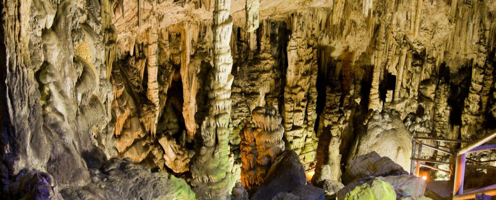
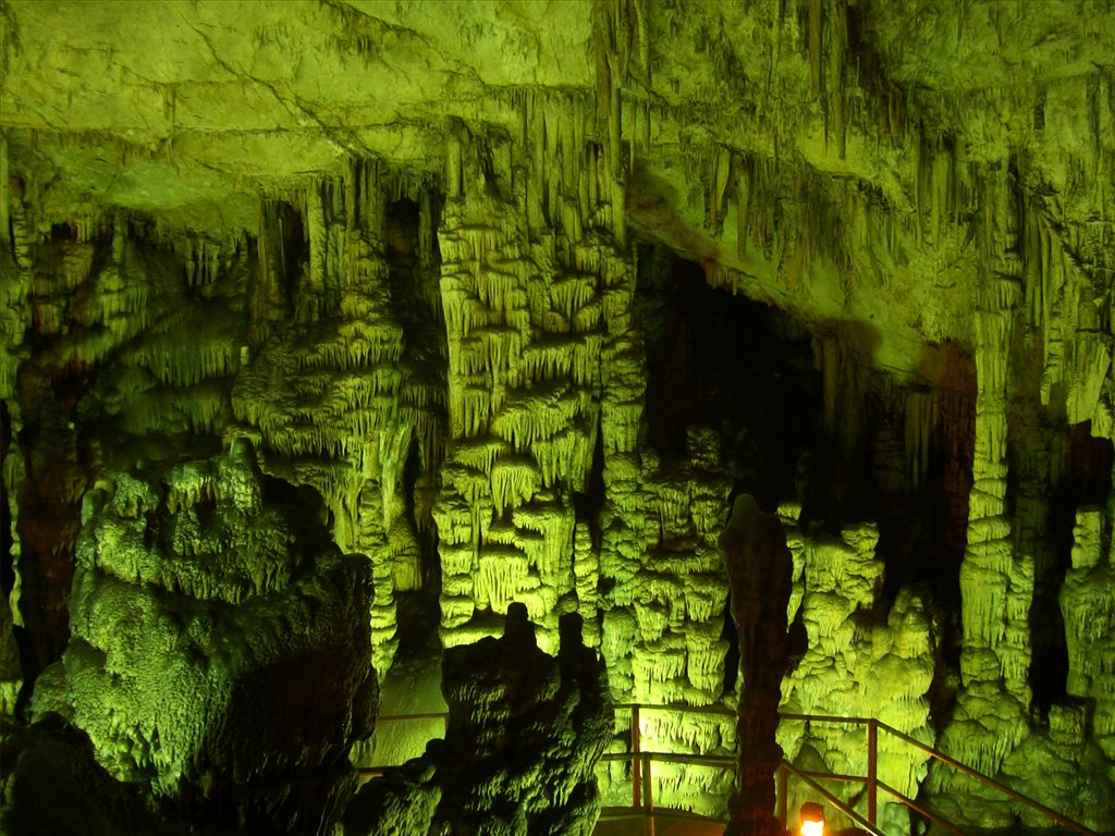
The cave of Psychro
is one of the most important cult places of Minoan Crete. The use of caves as cult places was one of the basic characteristics of the religious
beliefs of the ancient Cretans. Cult practice probably begins in the Early Minoan period (2800-2300 BC) - although in the antechamber are
preserved traces of an even earlier occupation - but the most important finds date from the Middle Minoan period (1800 BC) and later, as
it was used for many centuries, until the Geometric (8th century BC) and the Orientalising-Archaic period (7th-6th century BC). The finds
prove that it was visited until as late as the Roman period. Pilgrims dedicated many offerings, such as figurines of humans, gods, animals,
double axes etc. The excavators and several scholars identify the cave as the famous "Diktaian Cave", where Zeus was born and brought
up with the aid of Amaltheia and the Kouretes, and which is connected with myths as this of the seer Epimenides who "slept" here, or the
coupling of Zeus with Europa.
In the last decades of the 19th century, inhabitants of the area found ancient items inside the cave; this fact led in 1886 the
archaeologists Joseph Chatzidakis and F. Halbherr to the site, where they conducted an excavation, but not on a large scale. The cave
was also investigated by A. Evans in 1897, by J. Demargne, and by G. Hogarth in 1899, but systematic excavation has not taken place yet.
The finds uncovered during legal and illegal excavations were almost all published in 1961 by J. Boardman.
At 1,025 m. a.s.l., a steep path leads up
to a plateau in front of the narrow entrance to the cave.
On the right side is an antechamber (42 x 19 m.) with a rectangular altar, 1m. high, built of field stones; this area yielded Neolithic potsherds,
Early Minoan burials (2800-2200 BC), and offerings of the Middle Minoan period (2200-1550 BC). In the northern part of the antechamber, at
a lower level, a chamber is formed, which included an irregular enclosure with patches of roughly paved floor, forming a sort of a temenos.
The large hall (84 x 38 m.) has an inclined floor and a small chamber opening to the left end; one of its niches is called the "cradle"
of Zeus. A larger chamber (25 x 12 m.) formed on the right side is divided into two parts: one has a small pool, and the other a very impressive
stalactite, known as "the mantle of Zeus". Inside
the main chamber had been deposited many offerings, mostly bronze figurines and sheets, daggers, arrowheads, and double axes.
On the north side of Mount Dikte, in the Lassithi Plateau is the Dikteon
Andron Cave, the legendary birthplace of Zeus. The cave entrance is reached either
by walking or by a donkey ride. Good shoes with a non-slip tread are necessary.
A local man will provide a ride up and down and will give a tour of the cave with
a flashlight. Most of the guides speak only Greek. The cave entrance is reached
after a 20-minute walk up a stony path. The entrance is at 1,025 metres above
sea level and is 14.8 metres wide.
The cave of Dikteon Andron became more important than the cave of Trapeza (also
in the Lassithi Plateau) during the Prepalatial Period (2000-1700 B.C.). Its fame
continued throughout the Greek times (about 700 B.C.) when it lost its importance
to the Ideon Andron Cave in Rethimnon. Many bronze figurines, double axes, rings
and broaches have been found and are shown in the Iraklion Museum.
The cave consists of two parts: the antechamber is flat and has a length of 42
metres, a width of 19 metres and a height of 6.5 metres. An altar was here and
around it were tables for offerings which indicates that the cave was a cult centre
from the Minoan Period on. The second part is the main cave and slopes downward
leading to the lake and the four chambers at its end.
According to the legend, Zeus' father, Kronos, had sworn to devour all his children
to avoid losing his kingdom. Rhea tricked him by giving him a stone to swallow
and left Zeus in the Dikteon Cave. Here the goat nymph Amalthia nurtured him and
the Kuretes (5 Cretans) protected him. They banged their shields to drown out
the baby's crying.
This text is cited Feb 2003 from the Crete TOURnet URL below, which contains images.


PLATI (Village) OROPEDIO LASSITHIOU
It was a dwelling place from the Late Minoan Period until the Classical Times (excavations 1914)
ETIS (Ancient city) SITIA
Tel: +30 28430 23917
On a small headland called Trypetos, 3km to the east of modern
Seteia lies a city of the Hellenistic period (middle of 4th - middle of 1st century BC), most probably
identified with the ancient city of Eteia. A Hellenistic dockyard has been uncovered
at the east coast of the headland. It is known that in 1960 the owners of the
land created plots for cultivation using digging machines which caused severe
damage to the buried antiquities. Since 1987 a systematic excavation has been
conducted by the Ephorate of Antiquities, under the direction of N. Papadakis.
The dockyard lies at the south edge of the east side of the headland
called "Karavopetra" or "Trypetos". It is unroofed, hewn out of the rock and is
rectangular in shape (30m. long, 5.50 m. wide, and 5 m. high). The floor is slightly
inclined towards the sea (15-30 degrees) and does not continue under the sea level,
but this is due to the geological changes that have taken place in the past centuries.
The ship which would be sheltered under this structure during winter time, must
have been of a medium size. Carvings on the surface of the rock indicate the existence
of a wooden "bolt" for the fastening of the ship. Other parts of the building,
such as floor, saddle roof and towing machines were made of wood and have not
been preserved.
The Hellenistic city covers the whole of the headland and was built
on terraces, following the terrain. The south side was protected by a massive
wall, which separates the main area of the headland from the mainland. The wall
is built of cobblestones and its width reaches 1,8 m. on the uncovered sections.
Along the inner side are rooms and other structures, parts of houses and military
installations. The most important room seems to be a hall measuring 7,5 x 5 m.,
at the centre of which lies a rectangular hearth, formed by the surface of the
bedrock, enclosed by poros slabs smoothed outside. Behind the south side of the
hearth there is a small poros bench with an oblong cutting in the middle, which
contained the lower part of a poros plug, undoubtedly part of a relief or statuette
relating to cult practice at the hearth. A U-shaped built bench surrounding the
hearth was attached to the wall; it was probably used as a seat by the inhabitants.
Also uncovered were a storeroom, a cistern lined with hydraulic stucco, and stone
paved streets, one of which separates two neighbourhoods. Among the most important
finds is a series of coins cut by this city, which had its own mint.
PRESSOS (Ancient city) SITIA
The important ancient city of Pressos was the homeland of the Eteocretans--the
true Cretans. These people withdrew to these three hills, built a city and continued
their Minoan culture when the Dorians invaded. Remains of an older and newer city
were found as well as very important tablets written in the Minoan language using
Greek characters. This may help in the deciphering of the Minoan language. The
site was inhabited continually from Neolithic to Hellenistic times. Pressos dominated
the east side of Crete, and it had two harbours, one on the north coast--Itia,
the site of Sitia--and the other one, Stiles, on the south coast. The excavations
have revealed three acropolises, temples, houses, and tombs, but little remain
to be seen in the site. From the acropolis, where some ruins still remain, one
has a good view of the old harbour of Pressos, Sitia in the distance. Pressos
was in continuous struggle with the powerful cities of Itanos and Ierapytna for
the control of the Temple of Zeus Dicteos in Palaikastro. Although at some point
in time it even shared citizenship with Ierapytna, it was destroyed by Ierapytna
about 155 B.C. and was never rebuilt. The inhabitants of Pressos left for Itia
(Sitia), their harbour on the north coast and established New Pressos there.
This text is cited Feb 2003 from the Crete TOURnet URL below, which contains images.
MYRTOS (Village) IERAPETRA
Another Minoan site was located in a place called Mirtos Pirgos. It
was active in the Early Minoan era, and, like the one in Fournou Korfi, it was
destroyed at the same time, but was rebuilt and used in later Minoan times. During
the New Palace Period the settlement had a large villa on the summit of the hill.
A cistern dating from the Old Palace Period is considered to be the deepest Minoan
cistern found in Crete.
The site at the top of a hill on the north side of the main road is signposted
before the entrance to Mirtos. There is a dirt road here that continues to the
Venetian bridge of the old road to Ierapetra. The path that starts at the base
of the hill close to the highway is difficult to see because of recent floods,
but as you go up it is clearly marked with white stones. The ascent takes about
15 minutes and is well-worth the effort. The Minoan villa at the crest had an
incredible view of the Libyan Sea and the surrounding area. A stepped street from
the town on the eastern hillside led to a paved courtyard in front of the house.
The cistern in the courtyard is from an earlier period and it was filled with
stones when the villa was built. The characteristic Minoan raised walk bordered
the front of the veranda. The border of the walk was made of purple limestone,
as were the bases of the wooden columns. The entrance to the villa from the veranda
was at the west end and led into a passage that continued north first to a staircase
(now covered for protection) and then a lightwell with a purple limestone floor.
A bench (also covered for protection) was opposite the lightwell. Remains found
in an east wing suggest a large and grand upstairs room. On the north side of
the hill below the villa are the remains of the deepest Minoan cistern found in
Crete. It appears that its outer wall gave way and it was not repaired, forcing
water to be hauled up from below. The intriguing finds from the area of Mirtos
are exhibited in the Museum of Agios Nikolaos and Iraklion.
This text is cited Feb 2003 from the Crete TOURnet URL below, which contains images.
TZERMIADO (Small town) OROPEDIO LASSITHIOU
The Trapeza Cave (Spileo Trapezas) is 10 minutes by foot from the
road that circles around Lassithi Plateau. The marked path is to the east of the
village of Tzermiado off the main road. This cave was a place of worship during
Neolithic, Minoan, Hellenistic, and Byzantine times. However, the importance of
this cave declined as the Dikteon Cave was used for worship during the Prepalatial
Period.
This text is cited Feb 2003 from the Crete TOURnet URL below, which contains image.
MOCHLOS (Small island) SITIA
This web site is a joint effort of the Geography and Classical Studies departments of the University of North Carolina at Greensboro.

ZAKROS (Port) LASSITHI
Tel: +30 28430 26897
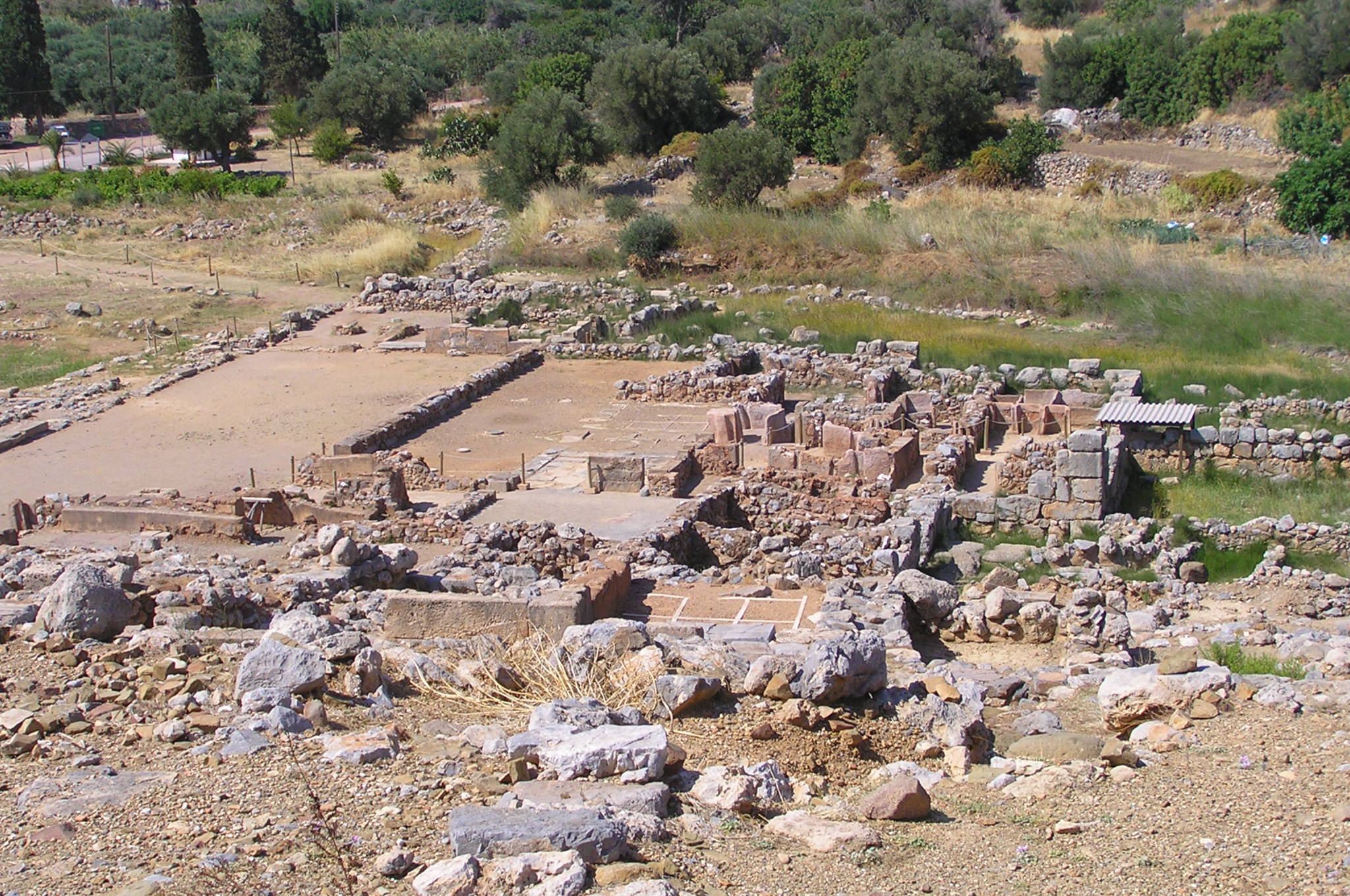
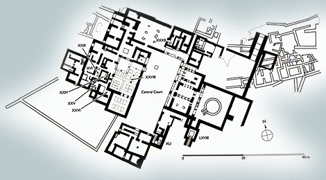
The palace of Zakros, the fourth largest of the Minoan palaces, was located at a protected bay of the Eastern Crete, an area of strategic importance to the trade and communication with Egypt and Near East. It is also possible that Zakros was one of the major bases of the Minoan fleet in Crete. From the site of Zakros came some of the masterpieces of Minoan art. The wealth of artifacts unearthed and the fact that many of them were made by rare, as well as imported raw materials, such as ivory, faience and copper, indicate the economical growth and vigour of the palace and its significance as the administrative and cult centre of the area.
The first reference to the ancient ruins of Zakros is found in the book Travels in Crete by Th. Spratt, an English admiral and renowned traveler of the mid-19th century. During the first half of the 20th century, excavations at a larger or smaller scale were conducted in the area by Italian and English archaeologists, among them the excavator of Knossos, Sir Arthur Evans. Although their investigations came too close, the discovery of the palace and the revealing of its surrounding city were to be made by Prof. Nikolaos Platon, who began his systematic excavations on the site in 1961.
As is the case with the rest of the Minoan palatial complexes, the palace at the end of the small valley of Kato Zakros was initially built in 1900 BC, while the remains visible today belong to its second phase of construction, the so-called Neopalatial (New Palace period), dated to 1600 BC. The palace was destroyed by fire and abandoned around 1450 BC, sharing the same fate with the other Minoan centers.
Expanding over 8000 m2, the palace of Zakros is five times smaller than that of Knossos, however its plan follows the typical layout of the other Minoan palaces. The main entrance to the palace of Zakros is located at the northeastern side and here ends the long paved road that connected the port with the palace. From the central gate of the palace a stepped corridor leads to the central court. The whole complex is organized as four wings of once multi-storey and frescoed buildings, pinwheeling around the central courtyard, which is actually the nucleus of the palace. The dense and complex arrangement of the in total 300 apartments eloquently brings to mind the Labyrinth myth and explains why Crete was its birthplace.
The west wing was the primary place for worship and rituals. Through a reception hall one enters the grand Hall of Ceremonies, in which were found the two famous libation vessels (rhyta), namely the bull’s head rhyton and the rhyton depicting a peak sanctuary. Among the findings were also large bronze saws 1.70 m long, which only two people together could handle. The ceremonial hall leads to the so-called banquet hall, while in the center of the western part of the wing lies the main sanctuary of the palace. It encompassed the typical Lustral Basin, used for some kind of purification ritual (katharmos), and the treasury, the only one of Minoan Crete that had escaped looting and was found intact during the excavations. Thus, the treasury yielded a spectacular collection of Minoan artifacts, such as magnificent stone ritual vases. On the other hand, the repository of the palatial records, the Archives Room, reserved a momentous discovery for the excavators, as, thanks to the fire that destroyed the palace, 13 Linear A tablets were baked and preserved inside clay caskets mounted on shelves. A later addition to the west wing seem to be the workshops which comprised the handcraft sector of the palace. One of them is in fact interpreted as a dyeing installation.
The east wing gathered the administrative functions of the palace and here are also placed the royal quarters, the so-called Queen’s Chamber and King’s Chamber, the latter being the largest hall of the palace. On this side is also found a structure that has no parallel in the Minoan architecture. This is the Basin Hall, namely a large square space with a circular open-air basin at its center, which collected the waters of a spring. At least five columns surrounded the basin, which reached a diameter of 7 m. and where one descends through eight steps, still preserved today. To the south is a subterranean fountain and to the west a built well, therefore the area must have been related to the water supply of the palace. Inside the well, water preserved wooden pieces of the mangle and a cup full of olives, a truly unique find.
To the south of the central courtyard was a small group of workshops making, among others, perfumes from local herbs. Next to it there was once a garden or an alsos (little forest). The north wing, which faced the courtyard forming a paved stoa with two wooden columns, provided access to the upper floors through a grand staircase. The rooms of the north wing are interpreted as auxiliary to the royal quarters. The cluster included storerooms, a bath and a large room, possibly the kitchen which served the banquet hall of the upper floor.
The palace was surrounded by the Minoan town, in fact the buildings of the settlement that are nearest to the palace are considered its appendices. It is noteworthy that Minoan Zakros had a sophisticated town planning and a complex network of stone paved roads. Each block included 2-4 houses, which, as indicated by their ruins, had two or three floors with many rooms. A particular characteristic found in many houses is the lack of entrance in the ground floor, in which cases the building is entered through a hatch opened on the first floor.
Ancient Zakros’ most well-kept secret, though, was hidden away from both the palace and the town, in the wild beauty of the gorge that leads from Ano to Kato Zakros. The numerous caves opened in its slopes became the burial ground for the prehistoric inhabitants of the area, surprising the archaeological research with a wealth of findings and attributing to the place the awesome name Gorge of he Dead.

KOUFONISSI (Island) LEFKI
Tel: +30 28410 22462, 25115
Fax: +30 28410 22462
The island of Leuke is mentioned by Pliny. A special reference is also
made in the inscription known as the "Diaitesia (arbitration) of the Magnetes",
built in the facade of the catholicon (main church) of the Toplou
Monastery. The inscription refers to the conflict between Itanos
and Ierapytna. Leuke was
an important station of sponge collecting and mainly, of the working of murex
shells, from which the famous, precious and expensive purple dye was extracted;
moreover, its position was strategic mainly for the ships that stopped on the
south-east coasts, and as a result became a reason of conflict between the two
cities. Itanos was justified in the end.
Leuke was continuously inhabited from the Early Minoan (3000-2200
BC) until the Early Christian period and was finally abandoned in the 4th century
AD. The very restricted human presence on the island thereafter (it was used
only for cultivation and stock-breeding) greatly contributed to the preservation
of the antiquities as it actually remained uninhabited, although the largest part
of its surface was covered with sand.
The English admiral Th. Spratt was the first who visited the island
in the middle of the 19th century and made detailed descriptions of the ancient
remains he managed to locate: a temple in the south, with fragments of a marble
statue, a settlement in the northern part of the island, and water cisterns in
the centre. In 1903, the English archaeologists R.C. Bosanquet and Ct. Curelly
conducted a survey to locate the ruins mentioned by Spratt, while in 1971 A. Leonard
Jr. carried out a more thorough investigation. Systematic excavation started in
1976 by the 24th Ephorate of Prehistoric and Classical Antiquities and is still in progress.
The most important monuments of the area are:
The theatre. At the north-east end of Kouphonesi, opposite the Marmara
islet, and at a small distance from the beach, excavations have brought to light
a well preserved stone-built theatre; the cavea had twelve rows of seats and a
capacity of c. 1000 persons. Part of the cavea and the stone seats are not preserved
today. The orchestra, almost semicircular in shape, was paved with clay slabs.
The stage building (measuring 20 x 19 m.) is destroyed in the western part, but
the eastern part, the paraskenion, the logeion, the hyposkenion and the east parodos,
which had a tholos roof are preserved. It seems that the theatre was severely
looted and destroyed by fanatic Christians in the 4th century AD.
The public baths. The second important
building of the settlement was in use from the 1st until the 4th century AD.
This bath complex, a typical Roman edifice, includes all rooms which were in use
in such a building: a garden (for the rest of the customers and visitors) around
which are arranged rooms; the central space - with walls preserved to a height
of 4 m. - two hypocausts, saunas and changing rooms.
The settlement extends to the SE of the theatre.
Very characteristic is a villa with eight rooms preserved; it has an imposing
propylon, kitchens, and a domestic workshop for the working of murex shells. Two
of its rooms have floors lined with black and white tesserae, forming geometric
patterns.
The temple. It lies in the southern part of the island,
and measures 18 x 15.70 m. It is preserved to the height of the crepis, and has
a central entrance on the narrow east side, and a second, stepped entrance on
the north. The temple is largely destroyed as its stones were used as building
material for the construction of the light-house. Two large pieces of a colossal
cult statue (more than 2.5 m. high) representing an enthroned deity were found
near the NW corner of the temple.
Cisterns. Very impressive are a series of spacious
tholos cisterns which provided water carried from sources with built pipes.
Caves on the west coast. They have been used as chapels
and preserve engraved representations of saints, and Latin inscriptions (one recording
the year 1638).
DRIROS (Ancient city) NEAPOLI
Region: Crete
Periods: Geometric, Archaic, Classical, Hellenistic, Roman, Byzantine
Type: Fortified city
Summary: Early Iron Age settlement and later a Classical city-state.
Physical Description:
In the Mirabello district of N Crete and NE of modern Neapolis,
Dreros occupies 2 small peaks on a S spur of Mt. Kadiston. The center and agora
of the ancient city sits on the saddle joining the E and W heights. Traces of
city fortification wall have been found.
Description:
The city was founded in the Geometric period and was most
prosperous in the 8th - 6th centuries B.C. Above and SW of the agora stood the
Temple of Apollo (built ca. 750 B.C.), one of the earliest known Greek temples.
In the temple were found early (ca. 650 B.C.) statuettes of Apollo, Leto and Artemis,
made of sheet-bronze hammered over wooden cores. Another important early find
from Dreros is the group of Archaic inscriptions (found in the fill of a later
Hellenistic cistern) that includes the earliest complete record of constitutional
law found in Greece. In the 3rd to 2nd centuries B.C. Dreros became first an ally
and then a dependent of Knossos. The city lost importance in the 2nd century B.C.,
but continued to exist into the Byzantine period.
Exploration:
S. Xanthoudides first excavated at the site in 1917. In
1932 P. Demargne began excavations for the French School and in 1935 S. Marinatos
excavated the Temple of Apollo. The French School resumed excavations in 1936.
Donald R. Keller, ed.
This text is cited Oct 2002 from The Perseus Project URL below, which contains 1 image(s), bibliography & interesting hyperlinks.
KARPHI (Prehistoric settlement) OROPEDIO LASSITHIOU
Region: Crete
Periods: Middle Bronze Age, Late Bronze Age, Dark Age, Geometric
Type: Settlement
Summary: An Early Iron Age Cretan refuge settlement with a temple
and associated tombs.
Physical Description:
Located on the remote upper SE slope of a high peak at
the N edge of the Lasithi plain, Karphi was a refuge settlement of ca. 150 rectangular
adjoining rooms representing an unknown number of individual residences. The settlement
was unwalled, but in a naturally defensible position with a stepped entrance at
its steep N edge. At the center of the settlement a "Great House" has been identified
by its superior construction and the number of finds of bronze artifacts. At the
N edge of the settlement, along the cliff edge, is a shrine or temple identified
on the basis of an interior altar and ledge for cult objects and finds of terracotta
figurines. The figurines follow the earlier Minoan tradition of females in bell-skirts,
up-raised arms, and crowns surmounted by birds and disks. Many stretches of the
twisting passages through the settlement were paved in stone. Remains of the settlement
extend E across the ridge top saddle that joins the Karphi peak to the summit
of Mikre Koprana. Associated tholos tombs are located outside the settlement to
the S.
Description:
A Middle Bronze Age Minoan peak sanctuary was located on the
summit of Karphi, but the settlement on the SE slopes was founded at the end of
the Late Bronze Age. After two centuries of occupation the settlement was abandoned
peacefully at ca. 900 B.C.
Exploration:
Excavations in 1937-1939 by Pendlebury and the British School
in Athens.
Donald R. Keller, ed.
This text is cited Oct 2002 from The Perseus Project URL below, which contains 1 image(s), bibliography & interesting hyperlinks.
FOURNOU KORYFI (Minoan settlement) IERAPETRA
Mirtos is an important Early Minoan (Prepalatial) settlement. The
settlement in Fournou Korfi was occupied from 2500 B.C. until 2170 B.C., when
it was destroyed by fire. Numerous examples of Vasiliki-style pottery were found.
The site excavation contributed valuable information about the first Minoan settlements.
The intriguing finds from the area of Mirtos are exhibited in the Museum of Agios
Nikolaos and Iraklion.
This text is cited Feb 2003 from the Crete TOURnet URL below, which contains images.
GOURNIA (Archaeological site) IERAPETRA
Tel: +30 28420 93028
Gournia
- the ancient name of which is not known - is the most characteristic example of an excavated medium-sized settlement,
dated to the period of the peak of the Minoan culture (Late Minoan I period: 1550-1450 BC). It is called "Pompeii of
Minoan Crete" because of the good state of preservation. It occupies a low hill, close to the sea, at the Isthmus of
Hierapetra. The first inhabitants settled
here in the Early Minoan III period (2300 BC). Remains of the Middle Minoan period (2000-1600 BC) are also preserved;
in c. 1600 BC, the palace was erected but was destroyed along with the surrounding town in 1450 BC, at the same time
with all the other palatial centres of Crete. Fifty years later the site was partly reoccupied and was finally abandoned in
around 1200 BC.
The excavations at Gournia were carried out in 1901-1904 by the American archaeologist Harriet Boyd-Hawes
and her colleagues, who were urged by the discovery of a sealstone in the site. The ruins of the settlement were visible
before the excavation - hence the name "Gournia" given by the villagers because of the
stone basins ("gournes" in Greek)
preserved in the area.
The most important monuments of the site are:
THE TOWN
The unfortified town extends on the slopes of the low hill. Two peripheral
paved streets cross at right
angles with others which climb the slopes of the hill and are often stepped; they are all connected to a drainage
system and divide the town into insulae, seven of which have already been excavated. The two-storeyed houses
(the larger measuring 5 x 5 m) have common outer walls. Preserved today are the magazines and workshops
of the ground-floor and the underground rooms, reached by wooden ladders from the upper floor. The upper
floor, the actual residential quarters, is accessible by a staircase directly from the street. The walls of the lower
part of the buildings are stone built, but the superstructure was built of mud bricks. The town of Gournia offers
a picture of everyday life of the Minoans: their main occupations were agriculture, stock-breeding, fishing, pottery,
and weaving, as indicated by the relevant tools (chisels, hooks, hammers etc.) found during the excavations.
Other, more luxurious vases (such as rhyta and ritual vases) were also uncovered.
THE PALACE
Seat of a local ruler, the monumental building of palatial type is built on the top of the hill, to the west
of the rectangular court, on which open many of the private houses. It was the centre and, possibly, the agora of
the town. A low flight of steps, L-shaped, is attached on the south side of the building, facing the court. It seems
that people sat here, to watch the ceremonies of ritual character, so the courtyard served as a primitive
"theatral area". Behind the
steps is a small room, paved with a stone with holes
which was thought to be a platform for bull sacrifices; beside it lay a "kernos" - a small stone with hollows - serving
for libations to the gods. The west side of the palace opened on a small paved west court, and had a monumental
facade, with recesses and projections, a door in the middle, and windows which are not preserved today. The interior
of the palace is not well preserved, but had several official rooms and magazines, over which were spacious halls.
The central hall of the palace was separated by the central court by a row of wooden columns, alternating with square
stone piers. To the north of the palace and independent from it lies a small public shrine dedicated to the Minoan
"Snake goddess". It lies at the end of a blind alley, is almost square (3 x 4 m.) and has a bench on the south side for the
deposition of religious oblects, some of which were found in the excavation: clay figurines of the goddess with raised arms,
a tripod altar, and snake tubes.
KARPHI (Prehistoric settlement) OROPEDIO LASSITHIOU
Karfi, meaning "big nail" in Greek, is the mountain with
the last of the Minoan settlements. The peak of Karfi was originally a sanctuary
like Maza. When the Dorians migrated to Crete, true Minoans (Eteocretans) retreated
to this mountain and in retreat built a settlement on its slopes. J. D. S. Pendlebury
and the British Archaeology School extensively excavated the ruins in the 1930s.
From their high villages the Minoans had a view of the Cretan Sea, the valley
of Pediada, and the plateau of Lassithi. Although it is difficult to make out
the buildings and streets of the site you will have a magnificent view of Iraklion,
the Lassithi Plateau, and the Dikte Mountains. The concrete post at the top marks
the site. The settlement stretched between the two peaks and over the northeast
slope of Karfi. The Minoan civilization survived intact here for about 400 years
after the occupation of Knossos. Several clay religious figurines have been found
there including the cylindrical skirted goddesses with their hands raised in a
prayer position that are now displayed in the Archaeological Museum of Iraklion
(Room 11).
This text is cited Feb 2003 from the Crete TOURnet URL below, which contains images.
MOCHLOS (Small island) SITIA
Mochlos has extensive Minoan remains. In 1908, the American archaeologist,
R.B. Seager, discovered several important tombs on the offshore island, some of
which contained excellent examples of jewellery, bronze tools, and weapons. Fine
stone vases also indicate the affluence of the inhabitants. This treasure is displayed
in the Iraklion and Agios Nikolaos Museums. In Minoan times, the little island
of Mochlos was probably connected with the mainland of Crete, thus forming small
harbours protected from east and west winds on both sides of the connecting peninsula.
This area is used as an anchorage point even today. There are one or two tavernas
and rooms for rent in the village. It is also possible to visit the site in calm
weather by making local arrangements. There is also a small harbour and a stony
beach.
This text is cited Feb 2003 from the Crete TOURnet URL below, which contains images.
PALEKASTRO (Small town) ITANOS
Tel: +30 28430 23917
At the northernmost edge of the eastern coast of Crete lie the ruins of a settlement
which flourished during the Late Minoan period (1550-1220 BC). At the same site, however, are preserved remains of the Early and Middle Minoan periods (3000-1550 BC), mostly cemeteries with well-built ossuaries, and ruins of spacious houses. The site ceased to be inhabited at the same time when Zakros was abandoned (1450 BC) but was reoccupied during the Late Minoan III period (1300-1200 BC). The city covered a total area of more than 50,000 sq.m., was densely inhabited but not fortified.
To the NE of one of the city's sectors lies the sanctuary of Diktaian Zeus, which belonged administratively to the city of Itanos.
Cult practice was continuous from the Geometric period (8th century BC) until the Roman conquest. It seems that the sanctuary was plundered and destroyed by fanatic Christians at the end of the 4th century AD.
The site of the Minoan settlement, called Roussolakkos, was excavated by R.C. Bosanquet and in 1906 by R.M. Dawkins, both members of the British School of Archaeology at Athens. The excavated sectors of the settlement suffered destruction during the Second World War and much later, by a digging machine. In 1965-66 excavations were conducted in part of the settlement and on the neighbouring hill of Kastri. In 1986 excavations were resumed by the British School of Archaeology and are still in progress.
THE MINOAN TOWN
The settlement is divided in nine sectors by a network of streets, namely a central street running through the habitation area crossed by larger and smaller paved streets (some of them stepped). The town had an elaborate drainage system in all sectors. All the houses along the central street have imposing facades.
Sector B. It includes five houses with external walls built of large blocks, while the internal walls were build of mudbricks. The thresholds, the pavements of the floors and the column bases were made of a special kind of limestone, brought in by Kavo Sidero. The most important of these houses (rooms 1-22) had an entrance from the main street, while from the same room started a staircase leading to the second floor. Behind this room was an open courtyard with wooden columns, of which only the stone bases are preserved, alternating with square piers. Antechambers lead to the "megaron", the main room of the house which had four column bases at the corners of a square. This structure has been interpreted as a light-well. The house also includes kitchens, a lustral basin, a well, a domestic shrine, an oil magazine, a bath and a reception hall which was later divided into smaller quarters and converted into storerooms. Interesting in the same sector is the installation of an olive-press, and the pithoi employed for the storage of oil.
Sector D. It is the largest (1,800 sq.m.) and consists of many houses, the most important of which (rooms 18-40) has a "megaron" with a light-well, like the one in the main house of sector B. Also preserved is a channel which carries the rainwater from the open inner court to the street.
Sector C. The largest house of this sector has a luxurious facade made of large ashlar blocks, a second entrance, a "megaron" with light-well, a bath, and a workshop. Many of the vases found show egyptian influence in their decoration. The houses, as in other sectors, seem to have been destroyed by fire.
Sector E. It consists of at least four houses, some of which are built on earlier foundations; it is remarkable that one of these houses was occupied in historic times, as well. In the same sector a wine-press was also uncovered.
The sanctuary of Diktaian Zeus lies to the NE of sector X, inside the house foundations. An inscription broken in many pieces, preserving a hymn to Diktaian Zeus was discovered in the surrounding area. Of the temple are preserved only the precinct and the altar inside it. Antefixes in the shape of lion-heads were found in the same area.
Palaikastro was one of the largest Minoan cities, about half the size
of Knossos, but much larger than the cities around the other important palaces.
Extensive excavations are being carried out in the area. In Kastri, on the hilltop
near the sea, extensive fortifications from the Early and Late Minoan eras have
been found. Below the hill of Kastri there is an area which is protected from
the strong winds of this region and which forms a natural anchorage point. It
was the harbour of Palaikastro in Minoan times. In front of Palaikastro, the Grand
Islands can be seen and, on a clear day, the islands of Kasos
and Karpathos are visible.
This chain of islands was a natural route from Crete towards Rhodes
and Asia Minor in Minoan
times.
The large site of Minoan excavations of Palaikastro is located in
Rousolacos, not far from the beach. A group of public buildings, whose function
is still unknown, have been excavated. A number of important finds including Linear
A writing have been found in the area. The Archaeological
Museum of Sitia displays the most impressive find--a chryselephantine kouros
(Palaikastro Kouros) of exceptional quality which is not to be found after this
period for almost another thousand years.
In the Greek era, Palaikastro was known for the dispute between the
major Greek cities of eastern Crete, Ierapytna
and Itanos, over control
of the Temple of Zeus Dicteos of Palaikastro. The location of the temple has been
identified but the temple has been destroyed. In the Archaeological
Museum of Iraklion there are fragments of the temple which record the Hymn
to Zeus Dicteos and a clay tablet with a relief of a chariot scene.
This text is cited Nov 2003 from the Crete TOURnet URL below, which contains images.
VASSILIKI (Settlement) IERAPETRA

Receive our daily Newsletter with all the latest updates on the Greek Travel industry.
Subscribe now!

