Εμφανίζονται 27 τίτλοι με αναζήτηση: Πληροφορίες για τον τόπο στην ευρύτερη περιοχή: "ΣΑΝΤΟΡΙΝΗ Νησί ΚΥΚΛΑΔΕΣ" .
ΣΑΝΤΟΡΙΝΗ (Νησί) ΚΥΚΛΑΔΕΣ
Το νησιώτικο σύμπλεγμα της Σαντορίνης αποτελείται από τα νησιά Θήρα,
το μεγαλύτερο, Θηρασία
το μικρότερο και το Ασπρονήσι
που είναι ακατοίκητο. Τα τρία αυτά νησιά είναι υπολείμματα του προϊστορικού μεγάλου
νησιού με τα ονόματα Στρογγυλή από το σχήμα του και μετέπειτα Καλλίστη από την
ομορφιά του.
Από την καταβύθιση του κέντρου της Στρογγυλής, μετά από μεγάλη ηφαιστειακή
έκρηξη, γύρω στα 1450π.Χ σχηματίστηκε η Καλντέρα (λεκάνη), στην οποία εισέρευσε
η θάλασσα και στο κέντρο της αναδύθηκαν μετά από αιώνες τα νησιά των Ηφαιστείων
(Καμένες), η Παλαιά Καμένη
αρχικά και η Νέα Καμένη μετά
από αιώνες.
(Κείμενο: Μανώλης Λιγνός)
Το κείμενο παρατίθεται το Φεβρουάριο 2004 από τουριστικό φυλλάδιο του Δήμου
Θήρας (2003-2004).
Έντονη είναι η νυχτερινή ζωή στην πόλη και στις παραλίες του νησιού.
Μπαρ με ζωντανή Ελληνική και ξένη μουσική από συγκροτήματα. Καφετέριες, μπαρ,
καφετέριες και άλλα κέντρα διασκέδασης με μουσική απ’ όλο τον κόσμο δίνουν
την ευκαιρία για ξέφρενη διασκέδαση.
Το κείμενο (απόσπασμα) παρατίθεται το Μάρτιο 2004 από τουριστικό φυλλάδιο
του Δήμου Θήρας.

Thera (Ion. There: Eth. Theraios: Santorin), an island in the Aegaean sea, and
the chief of the Sporades, is described by Strabo as 200 stadia in circumference,
opposite the Cretan island of Dia, and 700 stadia from Crete itself. (Strab. x.
p. 484.) Pliny places Thera 25 Roman miles S. of Ios (iv. 12. s. 23). Thera is
said to have been formed by a clod of earth thrown from the ship Argo, to have
received the name of Calliste, when it first emerged from the sea, and to have
been first inhabited by the Phoenicians, who were left there by Cadmus. Eight
generations afterwards it was colonised by Lacedaemonians and Minyae under the
guidance of the Spartan Theras, the son of Autesion, who gave his name to the
island. (Herod. iv. 147, seq.; Pind. Pyth. iv. 457; Callin. ap. Strab. viii. p.
347, x. p. 484; Apoll. Rhod. iv. 1762; Paus. iii. 1. § 7, iii. 15. § 6, vii. 2.
§ 2.) Its only importance in history is owing to its being the mother-city
of Cyrene in Africa, which was founded by Battus of Thera in B.C. 631.
(Herod. iv. 150, seq.) At this time Thera contained seven districts (choroi, Herod.
iv. 153.) Ptolemy (iii. 15. § 26) has preserved the names of two places, Eleusin
or Eleusis, and Oea; and a third, called Melaenae, occurs in an inscription. (Bockh,
Inscr, no 2448.) Like Melos, Thera sided with the Lacedaemonians at the commencement
of the Peloponnesian War (Thuc. ii. 9), but of its subsequent history we have
no information.
Thera and the surrounding islands are remarkable as having been the
scene of active volcanic operations in ancient as well as in modern times. In
consequence of the survey made by command of the English Admiralty, we now possess
precise information respecting these islands, the result of which, with additional
particulars, is given by Lieutenant Leycester in a paper published in the Journal
of the Royal Geographical Society, from which the following account is chiefly
taken. Thera, now called Santorin, the largest of the group, has been likened
in form to a horse-shoe; but a crescent with its two points elongated towards
the west would be a more exact description. The distance round the inner curve
is 12 miles, and round the outer 18, making the coast-line of the whole island
30 miles: its breadth is in no part more than 3 miles. Opposite to Thera westward
is Therasia, which still bears the same name. (Strab. i. p. 57, v. p. 484; Steph.
B. s. v. Therasia; Ptol. iii. 15. § 28; Plin. ii. 87, s. 89, iv. 12. s. 70.) Its
circuit is 7 1/2 miles, its length from N. to S. about 2 1/2 miles, and its breadth
a mile. About 1 3/4 mile S. of Therasia, lies Aspronisi, or White Island, only
a mile in circuit, and so called from being capped with a deep layer of pozzolana;
the name of this island is not mentioned by the ancient writers. These three islands,
Thera, Therasia, and Aspronisi, enclose an expanse of water nearly 18 miles in
circumference, which is in reality the crater of a great volcano. The islands
were originally united, and were subsequently separated by the eruption of the
crater. In the centre of this basin three volcanic mountains rise, known by the
name of Kammeni or the Burnt, (kammene, i. e. kaumene instead of kekaumene), and
distinguished as the Palaea or Old, the Nea or New, and the Mikra or Little. It
was formerly asserted that the basin was unfathomable, but its depth and shape
have been clearly ascertained by the soundings of the English Survey. Supposing
the basin could be drained, a gigantic bowl-shaped cavity would appear, with walls
2449 feet high in some places, and nowhere less than 1200 feet high, while the
Kammenis would be seen to form in the centre a huge mountain 5 1/2 miles in circumference
with three summits, the Palaea Kammeni, the Nea Kammeni, and the Mikra Kammeni,
rising severally from the bottom of the abyss to the height of 1606, 1629, and
1550 feet. The rim of the great crater thus exposed would appear in all parts
unbroken, except at the northern point between Thera and Therasia, where there
is a chasm or door into the crater about a mile in width, and 1170 feet in depth
midway between the two islands. If we now suppose the waters of the Aegaean let
in, the edges of the crater, forming the inner curve of Thera and Therasia, rise
above the sea from the height of 500 to 1200 feet, and present frightful precipices,
of the colour of iron dross, except where their summits are capped with a deep
layer of pozzolana. The Palaea Kammeni is 328 feet above the water; the Nea Kammeni
351 feet; and the Mikra Kammeni 222 feet.
Thera, Therasia, and Aspronisi are all composed of volcanic matter,
except the southern part of Thera, which contains Mount Elias, of limestone formation,
the peak of which rises 1887 feet above the level of the sea, and is the highest
land in the island. This mountain must have been originally a submarine eminence
in the bed of the Mediterranean before the volcanic cone was formed (Lyell, Principles
of Geology, p. 445, 9th ed.).
The first appearance of the three Kammenis belongs to historical times,
and has been narrated by several writers. The Nea Kammeni, which is the largest
of the group, did not emerge till the year 1707; but the other two were thrown
up in ancient times. The exact time of their appearance, however, is differently
related, and it is difficult, and in some cases impossible, to reconcile the conflicting
statements of ancient writers upon the subject. It appears certain that the oldest
of these islands is the most southerly one, still called the Palaea or Old Kammeni.
It burst out of the sea in B.C. 197, and received the name of Hiera, a name frequently
given in antiquity to volcanic mountains. This fact is stated by Eusebius, Justin,
Strabo, and Plutarch. It is related by Strabo that flames burst out of the sea
for four days, and that an island was formed 12 stadia or 1 1/2 English mile in
circumference. (Euseb. Chron. p. 144, Olymp. 145. 4; Justin, xxx. 4; Strab. i.
p. 57; Plut. de Pyth. Or. 11. p. 399.) The unanimous statement of these four writers
is, however, at variance with that of Pliny (ii. 87. s. 89), who says that in
the 4th year of the 135th Olympiad [B.C. 237] there arose Thera and Therasia;
between these islands, 130 years later [B.C. 107], Hiera, also called Automate;
and 2 stadia from the latter, 110 years [A.D. 3] afterwards, in the consulship
of M. Junius Silanus and L. Balbus, on the 8th of July, Thia. In another passage
he says (iv. 12. s. 23): Thera, when it first emerged from the sea, was called
Calliste. Therasia was afterwards torn away from it; between the two there presently
arose Automate, also called Hiera; and in our age Thia near Hiera. Seneca refers
apparently to the events mentioned by Pliny, when he states (Qu. Nat. ii. 26),
upon the authority of Posidonius, that an island arose in the Aegaean sea in the
memory of our ancestors (majorum nostrorum memoria), and that the same thing happened
a second time in our memory (nostra memoria) in the consulship of Valerius Asiaticus
[A.D. 46]. (Comp. Qu. Nat. vi. 21.)
According to the preceding statements there would have been five different
eruptions of islands in the space of little more than 200 years. First Thera and
Therasia themselves appeared in B.C. 237, according to Pliny; secondly Hiera,
according to Eusebius, Justin, Strabo, and Plutarch, in B.C. 197; thirdly Hiera
or Automate, according to Pliny, 130 years later than the first occurrence, consequently
in B.C. 107; fourthly, according to Pliny, 110 years afterwards, Thia, that is
in A.D. 3; fifthly, according to Seneca and other writers, who will be mentioned
presently, an island in the reign of the emperor Claudius, A.D. 46.
Now it is evident that there is some gross error in the text of Pliny,
or that he has made use of his authorities with a carelessness which is not unusual
with him. The most surprising thing is, that he has omitted the eruptions of the
islands in B.C. 197 and A.D. 46, which are guaranteed by several authorities.
His statement that Thera and Therasia first appeared in the 4th year of the 135th
Olympiad, i. e. B.C. 237, is absurd, as they are mentioned by Callinus and Herodotus,
and must have existed even long before the time of those writers; but if we suppose
a slight error in the numerals in the text of Pliny (reading Olympiadis cxxxxv
anno quarto instead of. Olympiadis cxxxv anno quarto. ), we have the very year
(B.C. 197) in which Eusebius and Justin place the appearance of Hiera. There can
be little doubt, therefore, that Pliny's authorities referred to this event, and
that it was only through carelessness that he spoke of the appearance of Thera
and Therasia in that year. Thus the first statement of Pliny may be reconciled
with the accounts of Eusebius, Justin, and the other writers. The appearance of
the second island, to which he falsely transfers the name of Hiera from the earlier
occurrence, must be placed in B.C. 67, according to the corrected chronology.
This. island no longer exists; and it must therefore either have been thrown up
and disappeared again immediately, as was the case in the eruption of 1650, or
it was simply an addition to the ancient Hiera, of which there are some instances
at a later period. It is apparently to this eruption that the statement of Posidonius,
quoted by Seneca, refers. The last statement of Pliny that a new island, named
Thia, was thrown up 2 stadia from Thia in the consulship of M. Junius Silanus
and L. Balbus, on the 8th. of July, is so exact that it seems hardly possible
to reject it; but here again is an error in the date. If we take the numbers as
they stand, this event would have happened in A.D. 3, or, according to the corrected
numbers, in A.D. 43, whereas we know that M. Junius Silanus and L. Balbus were
consuls in A.D. 19. No other writer, however, speaks of an eruption of an island
in this year, which, if it actually happened, must again have disappeared. Moreover,
it is strange that Pliny should have passed over the eruption of the real Thia,
or Mikra Kammeni, which occurred in his lifetime, in the consulship of Valerius
Asiaticus, and in the reign of Claudius, A.D. 46. This event, with the difference
of only a single year, is mentioned by several writers. (Senec. Qu. Nat. ii. 26,
vi. 21; Dion Cass. lx. 29; Aurel. Vict. Caes. 4, Epit. 4; Oros. vii. 6; Amm. Marc.
xvii. 7; Georg. Cedren. i. p. 197, ed. Par.) Moreover Pliny himself, in another
passage (iv. 12. s. 23), says that Thia appeared in our age ( in nostro aevo ),
which can hardly apply to the consulship of Silanus and Balbus, since he was not
born till A.D. 23.
In A.D. 726, during the reign of Leo the Isaurian, Hiera, or the Palaea
Kammeni, received an augmentation on the NE. side. (Theoph. Chronogr. p. 338,
ed. Paris.; Cedren. i. p. 454, ed. Paris.; Nicephor. p. 37, ed. Par.) There have
been several eruptions in modern times, of which a full account is given by Lieut.
Leycester and Ross. Of these one of the most important was in 1573, when the Mikra
Kammeni is said to have been formed. But as we have already seen from several
authorities that an island was formed in the reign of Claudius, A.D. 46, we must
suppose either that the last-mentioned island sunk into the sea at some unknown
period, and made its appearance a second time as the Mikra Kammeni in 1573, or
that there was only an augmentation of the Mikra Kammeni this year. The latter
supposition is the more probable, especially since Father Richard, who records
it, was not an eye-witness, but derived his information from old people in the
island. There was another terrible eruption in 1650, which Father Richard himself
saw. It broke out at an entirely different spot from all preceding eruptions,
outside the gulf, off the NE. coast of Thera, about 3 1/2 miles from C. Kolumbo,
in the direction of Ios and Anydros. This submarine outbreak lasted about three
months, covering the sea with pumice, and giving rise to a shoal, which was found
by the English Survey to have 10 fathoms water over it. At the same time the island
of Thera was violently shaken by earthquakes, in which many houses were overthrown,
and a great number of persons and animals were killed by the pestilential vapours
emitted from the volcano. The sea inundated the flat eastern coast of the island
to the extent of two Italian miles inland. The ruins of two ancient towns at Perissa
and Kamari were disinterred, the existence of which was previously unknown, and
which must have been overwhelmed by some previous eruption of volcanic matter.
The road also, which then existed round Cape Messa-Vouno, was sunk beneath the
waters.
For the next 50 years, or a little longer, the volcanic fires slept,
but in 1707 they burst forth with redoubled fury, and produced the largest of
the three burnt islands, the Nea Kammeni. It originally consisted of two islands.
The first which rose was called the White Island, composed of a mass of pumice
extremely porous. A few days afterwards there appeared a large chain of dark rocks,
composed of brown trachyte, to which the name of the Black Island was given. These
two islands were gradually united; and in the course of the eruptions, the black
rocks became the centre of the actual island, the Nea Kammeni. The White Island
was first seen on the 23rd of May, 1707, and for a year the discharges of the
volcano were incessant. After this time the eruptions were less frequent; but
they continued to occur at intervals in 1710 and 1711; and it was not till 1712
that the fires of the volcano became extinct. The island is now about 2 1/2 miles
in circuit, and has a perfect cone at its SE. side, which is 351 feet high. From
1712 down to the present day there has been no further eruption.
There are several thermal and mineral springs at Thera and the surrounding
islands, of which Lieut. Leycester gives an account, and which are more fully
described by Landerer in the treatise entitled Peri ton en Therai (Santorenei)
thermon hudaton, Athens, 1835. The most important are the iron springs in a bay
on the SE. side of Nea Kammeni. There are springs on the NE. side of Palaea Kammeni,
likewise near Cape Exomiti in the south of Thera, and at other places. Fresh water
springs are very rare at Thera, and are only found round Mount Elias springing
from the limestone. The inhabitants depend for their supply of water upon the
rain which they catch in the tanks during the winter.
The principal modern town of the island is now called Thera, or Phira,
and is situated in the centre of the curve of the gulf. When Tournefort visited
Thera, the capital stood upon the promontory Skaro, a little to the N. of the
present capital, and immediately under the town of Merovouli. The promontory Skaro
projects about one third of a mile into the sea; and upon it are the remains of
a castle built by the dukes of Naxos. The chief town in the island, after the
capital, is Epanomeria, on the NW. promontory, and directly opposite to Therasia.
As space is of the utmost value in this small island, all the principal towns
are built upon the very edge of the cliffs, and present a very singular appearance,
perched in some cases more than 900 feet above the sea. Wood being very scarce,
the houses are excavated in the face of the vast beds of pozzolana. In order to
make approaches to the towns upon the cliffs, the inhabitants have cut zig-zag
stairs or roads in the sides of the precipices. The road upon the summit runs
along the edge of the precipices, and, in many cases, over the habitations, which
are built in the face of them. The population of the island in 1848 was about
14,000, and, including Therasia, about 14,380. In the time of Tournefort there
were 10,000 inhabitants, so that the increase has been nearly a third in about
150 years. The island is carefully cultivated; and the chief production is wine,
which is mostly exported to the Russian ports in the Black Sea.
The antiquities of the island have been explained at length by Ross
and Lieut. Leycester. There are remains of an ancient city situated on the SE.
point of the island, upon the summit of Messa-Vouno, a mountain about 1100 feet
above the level of the sea, connected with Mount Elias by the ridge of the Sellada.
The mountain of Messa-Vouno slopes suddenly off to the precipices on the NE. side,
which rise perpendicularly 600 feet above the water and form the cape of the same
name. The walls exhibit masonry of all ages, from the most ancient Cyclopean to
the regular masonry of later times. The walls may still be traced, and enclose
a circuit of only seven-tenths of a mile; but the houses appear to have been built
terrace-fashion upon the side of the hill. Several inscriptions, fragments of
sculpture, and other antiquities, have been discovered here. The name of this
city has been a subject of some dispute. In an inscription found below Messa-Vouno,
at Kamari, in the church of St. Nicholas, the name Oea occurs, which, as we have
already seen, is one of the two towns mentioned by Ptolemy. But in an inscription
upon some steps cut out of the rock of Messa-Vouno we find Thera polis. Ross,
however, does not consider this to be a proof that Thera was the name of tile
city spposing that polis here signifies only the political community of the Theraeans.
On the other hand, it was so usual for the islands of the Aegaean to possess a
capital of the same name, that, taken in connection with the inscription last
mentioned, it is probable, either that Ptolemy has accidentally omitted the name
of the capital, or that in his time the Theraeans had removed from the lofty site
at Messa-Vouno to Oea upon the sea-coast at Kamari, where submarine ruins still
exist. Upon the other or S. side of the Cape Messa-Vouno, at Perissa, there are
also so many ancient remains as to lead us to suppose that this was the site of
an ancient city, but no inscription has been discovered to give a clue to its
name. Upon either side of the mountain of Messa-Vouno there are numerous tombs.
South of Perissa is C. Exomiti, and a little to the N. of this cape
there are the remains of an ancient city, which is probably the Eleusis of Ptolemy.
Here are the ruins of a mole under water, and upon the side of the mountain many
curious tombs. There are likewise some ruins and tombs at C. Kolumbo, in the NE.
of the island, which Ross conjectures may be the site of Melaenae. The island
of Therasia possessed a town of the same name (Ptol. iii. 15. § 28), the ruins
of which were discovered by Ross opposite Epunomeria in Thera.
This text is from: Dictionary of Greek and Roman Geography (1854) (ed. William Smith, LLD). Cited August 2004 from The Perseus Project URL below, which contains interesting hyperlinks
Now Santorin; an island in the Aegaean Sea, and the chief of the Sporades, distant from Crete 700 stadia, and 25 Roman miles south of the Island of Ios.
An island of the Aegean; called also Thera.


Thera is the most southerly of the Cyclades, lying only 140 km north of Crete. Since 1626 B.C., when a violent volcanic eruption destroyed the island, Thera has taken the shape of a semicircle opening to the west. Across from the main island there are two smaller uninhabited islands: Therasia, with an area of 9 sq. km, and Aspronisi with an area of 2 sq. km. Excavations on these islands and at the site of Akrotiri have shown that Thera was flourishing and prosperous in the second millennium B.C., and while the inhabitants of the island were in contact with the Minoan civilization of Crete, they developed an individual and unique culture. Thera was not re-inhabited until many years after the huge eruption, when Dorian settlers established themselves on the island. On a southeastern section of the island, above the coastal village of Kamari, lies the rocky site of the ancient village of Thera. The site includes a temenos, a temple to Apollo Pythios and to Apollo Karneios, an agora, and a gymnasium with many inscriptions. There is an archaeological museum on the island which houses material from the Cycladic and Minoan periods.
This extract is cited Jan 2003 from The Perseus Project URL below, which contains bibliography & interesting hyperlinks.
The island is one of the Greek Cyclades group. Its modern name appears
during the mediaeval epoch, and is a corruption of Santa Irini. It is the most
striking of the Greek islands, reduced to a half-moon shape by successive volcanic
eruptions and earthquakes from prehistoric times to the present. According to
the ancient sources Thera would have been first inhabited by Carians, then by
Phoenicians, followed by Achaeans, Dorians, and Minyans. Scheria, the Homeric
island of the Phaiakians, has been recognized in Thera; others identify it with
the mythical Atlantis, destroyed according to legend by a gigantic cataclysm similar
to that which must have hit Thera ca. 1520 B.C. The submarine earthquake would
in fact have reached the island of Crete, where volcanic debris from Thera has
been found. It largely destroyed the Minoan palaces, including that of Knossos,
which was subsequently occupied by a new Achaean dynasty; and it caused a large
part of the population to emigrate to the mainland.
The exploration of Thera, begun in 1845, was systematically carried
on from 1895 to 1903, and has been resumed since WW II. A spot on the SW promontory,
in the locality of Akrotiri, is held because of its geographic position to be
probably the most ancient center of the island. There, sealed under a thick blanket
of lapillus, have appeared the imposing remains of constructions of palatial character.
They go back to a time contemporaneous with LM I, and attest the close ties of
Thera with Crete. They were buried at the end of the 16th c. after an eruption
that destroyed every trace of life and even changed the geographical aspect of
the island. Another settlement of Minoan type has been discovered on the S coast
of the small island of Therasia, which closes, on the N, the large gulf formed
by the caving-in of the volcano which occupied the center of the island in prehistoric
times.
At the beginning of the 1st millennium the Dorians landed at Thera,
bringing the cult of Apollo Delphinios and Karnesios. They settled on a sheltered
rocky highland on the sea, joined by a narrow ridge to mount St. Elias in the
SE part of the island. Here they founded a city, built on a single axis to conform
to the long narrow hill. Nothing remains of the most ancient city. Although the
actual remains are almost all post-6th c., it is probable, given the peculiar
geographic position, that the general plan of the primitive city coincided with
the later plan and extended beyond it, from the spring of Sellada to the N to
the religious zone to the S. This was closed by a vast temenos, inside of which
rose the Temple of Apollo Karneios, the oldest sanctuary of the Dorian colony,
perhaps datable to the 7th c.
The foundations of the temple were cut into the rock, while the upper
part was built of breccia and mudbrick. The plan is unusual, resembling a house
more than a temple. From the propylaeum, with two wooden columns in front of it
the stone bases of which are still visible, one enters a square court on which
open two rooms to the right, and to the left a pronaos communicating with the
cella (7.3 x 12.15 m) cut into the rock. The cella communicates with two other
rock-cut rooms which perhaps served as treasuries. Next to the temple, and sustained
by a Cyclopean wall, is the terrace where the festivals of Apollo (Karneia) were
celebrated. The interior rock walls and those of a small quadrangular room intended
for offerings are covered by numerous dedicatory inscriptions. The most ancient
of these go back to the 7th c. and are important in the history of Greek epigraphy.
Although there are many terrace walls from the archaic period, the
most conspicuous remains of the city belong to the Ptolemaic period, when Thera
became a powerful naval base. The road that crossed the entire inhabited area
opens in the middle and highest part of its route into an agora with an irregular
plan, ca. 20 m wide. Here other divinities were honored, including Athena Polias,
perhaps Zeus, and later Dionysos. On the W side of the agora rose the basilike
stoa, whose name perhaps recalls the Dorian kings, but which probably belongs
to the Ptolemaic period. It has the form of a basilica, divided into two naves
by a row of Doric columns. In the Roman period its N part was closed in to make
a room where statues of the imperial family were kept, including Faustina the
Elder, Marcus Aurelius, and Lucius Verus. A road to the W led to the barracks
of the Ptolemaic garrison (275 B.C.) on the summit of the hill, which consisted
of various rooms that could be approached from inside or outside the city. Beside
the barracks was a building enclosed in a square court that has been interpreted
as a gymnasium, although others claim that the construction is pre-Classical.
Between this building and the stoa were other constructions, among
them one with a cistern, a potter's wheel, perhaps the Temple of Dionysos, and
the Ptolomeion which Octavian, after the battle of Actium in 31 B.C., transformed
into a Kaisareion. Beside the Roman baths, S of the stoa, is the theater, in which
four building periods are recognizable between the late Hellenistic era and that
of Tiberius. Near the portal of the theater was found a Hellenistic house with
columns where the son of Ptolemy III Euergetes, who was brought up on Thera ca.
260 B.C., is presumed to have lived. In front of the theater, where the main road
veers to the E, a lateral road goes W to a small square with a Sanctuary of Apollo,
which has been transformed into a church. It also contained, among the rocks,
the Ptolemaic Sanctuary of Isis, Serapis, and Anubis, probably hypoethral.
At the S extremity of the city is a building complex that has been
identified as the gymnasium for young men because of inscriptions including lists
and ephebic names, some still in archaic characters, and dedications to Hermes.
The gymnasium is constructed in part on the rock and in part on an artificial
terrace supported by three strong terrace walls. Still preserved is an archaic
nucleus with a grotto dug into the rock and later transformed into a room. It
is dedicated to Hermes and to Herakles. Later structures were added in the 3d
c. B.C., including a rotunda with columns. At the center opens a roughly trapezoidal
court.
At the N extremity of the city is the Sanctuary of Demeter and Kore,
and a temenos dedicated by Artemidoros of Perge to various divinities, dating
from the 3d c. B.C. The necropolis in use during archaic, Classical, and Hellenistic
times is still being explored. It is at Sellada, on the NE slope of the hill,
along the road that led to the port of Oia. The archaic tombs were pits containing
cremation burials, with a simple cube on which was written the name of the deceased
serving as a funerary monument. In the Classical and Hellenistic tombs the ashes
were deposited in vases. Notable among the rich finds are three kouroi from the
end of the 7th c., painted local and imported pottery, and sculpted stelai from
the 5th c.
Descending from Sellada toward Perissa one finds the remains of a
heroon transformed into a sepulchral building during the early years of the Empire,
and the ruins of a Byzantine convent. The remains of Byzantine fortifications
are found N of the city. In the region of Akrotiri a temple from the 3d c. B.C.
in white marble with a rectangular plan, dedicated to Thea Basileia, has been
transformed into a chapel of St. Nicholas Marmarotis. Inside, before the door,
a niche flanked by two columns on each side held the ancient cult image. A new
museum was constructed at Thera in 1968.
L. Vlad Borrelli, ed.
This text is from: The Princeton encyclopedia of classical sites,
Princeton University Press 1976. Cited Feb 2003 from
Perseus Project URL below, which contains 19 image(s), bibliography & interesting hyperlinks.
Diocese in the Cyclades.
About the year 2000 B.C., the extinguished volcano of the island renewed
its activities, destroyed the population, and a portion of the island which was
engulfed in the sea. In 236 B.C. another eruption separated the island of Theresa
from Thera; in 196 B.C. the islet of Hiera sprang up (Palaeo-Kaimeni); in A.D.
46 appeared Thia, which was afterwards swallowed up by the sea; in 1570 a portion
of the island of Thera caved in; in 1573 and 1711 two new islands arose; in 1866
there was a new volcanic eruption which lasted two years.
The ancient town of Thera
has been discovered at Haghios-Stephanos, near Mesavouno; the Ptolemies established
an important garrison there. Some time after the eruption of the year 2000 B.C.,
the island called Calliste was repeopled by the Phoenicians, then by the Dorians
who named it Thera about the year 620 B.C.; it became successively a tributary
of Sparta, Athens,
the Ptolemies, and finally the Romans.
It is believed that Christianity was already introduced there in the
second century and that certain tombs belonged to that epoch; a very old church
dedicated to Saint Michael and other very ancient churches have been found there.
The See of Thera was a suffragan of Rhodes
in the seventh and tenth centuries. It became a metropolitan see in the eighteenth
century and after the incorporation of the island with the Kingdom of Greece
it was reduced in 1833 to a bishopric, which rank it still holds. In 1207 the
island fell into the power of a Latin lord, himself subject to the Duke of Naxos;
the population decreased continually and in 1457 there were no more than 300 persons.
In 1566 Thera fell under the domination of the Turks and took the
name of Deir-Menlik. It received the name of Santorin only in the Middle Ages
from Saint Irene to whom the island had a special devotion. A Latin diocese, suffragan
of Naxos, was established
there.
S. Vailhe, ed.
Transcribed by: Thomas M. Barrett
This extract is cited June 2003 from The Catholic Encyclopedia, New Advent online edition URL below.
After a devastating earthquake in 1956, most of the natives of Santorini sold up and left. In their stead came canny entrepreneurs and developers, and the island reinvented itself on the cornerstone of tourism. Today, Santorini -with its dark volcanic soil, towering cliffs, and jagged gorges- has an almost eerie quality to it: a heady melange of myth, romance, and just downright decadence. Rachel Howard journeys through this otherworldly paradise. . .(more information inside)

ΘΗΡΑΣΙΑ (ΣΑΝΤΟΡΙΝΗ) (Νησί) ΚΥΚΛΑΔΕΣ
Η Θηρασιά, που βρίσκεται απέναντι από την Οία, είναι το μεγαλύτερο και το μόνο κατοικημένο από τα νησάκια που σχηματίστηκαν από τη δραστηριότητα του ηφαιστίου γύρω από τη Σαντορίνη. Ιδιαίτερη γραφικότητα παρουσιάζει το Χωριό με τα κατάλευκα σπιτάκια του, στο οποίο καταλήγουν 250 σκαλοπάτια από το λιμάνι. Το χειμώνα συνδέεται με την Οία με τοπικά καϊκια, ενώ το καλοκαίρι τα τουριστικά γραφεία της Σαντορίνης διοργανώνουν εκδρομές από τα Φηρά ή τον Αθηνιό. Στο νησάκι υπαρχουν λιγοστά ενοικιαζόμενα δωμάτια.

ΟΙΑ (Χωριό) ΣΑΝΤΟΡΙΝΗ
Το παραδοσιακό χωριό της Οίας, 11 χλμ. Β. από τα Φηρά είναι μοναδικής ομορφιάς. Μικρά σπίτια λαξεμένα στο μαλακό βράχο, άλλα λευκά κι άλλα χρωματισμένα με γαλάζιο ή ώχρα, νεοκλασικά αρχοντικά με αυλές, στενοί πλακόστρωτοι δρόμοι, συνθέτουν τη ξεχωριστή εικόνα της. Η θέα προς το πέλαγος είναι μοναδική.
Η Σαντορίνη, το ξακουστό νησί των Κυκλάδων, ξεχωρίζει από τα υπόλοιπα Κυκλαδονήσια εξαιτίας της γεωλογικής της μορφολογίας που οφείλεται στη δράση του σβησμένου σήμερα ηφαιστείου. Ιδιαίτερα επιβλητικό είναι το τοπίο στη δυτική πλευρά του νησιού, όπου οι πελώριοι, απότομοι βράχοι, στολισμένοι στη κορφή τους με κατάλευκα σπιτάκια, βυθίζονται απαλά στο νερό. Οι ακτές του νησιού απότομες στα δυτικά μεταμορφώνονται σε απέραντες βοτσαλωτές ή αμμώδες παραλίες στην ανατολική πλευρά του. Από το λιμάνι, τη Σκάλα, ο επισκέπτης μπορεί να ανεβεί στην πρωτεύουσα τα Φηρά με τα πόδια, - από εκατοντάδες σκαλιά - με γαϊδουράκι ή με το τελεφερίκ .. .. Η γοητεία του τοπίου, η ιδιομορφία του φυσικού περιβάλλοντος, η εντυπωσιακή αρχιτεκτονική, καθώς και τα αξιόλογα μνημεία της συγκεντρώνουν, ιδίως τους καλοκαιρινούς μήνες, πολύ μεγάλο αριθμό επισκεπτών, στον οποίο μόλις ανταποκρίνεται η πολύ καλή τουριστική υποδομή του νησιού
ΦΗΡΑ (Κωμόπολη) ΣΑΝΤΟΡΙΝΗ
Η πόλη είναι γραφική με τους πολυδαίδαλους στενούς δρόμους, τις καμάρες, το φραγκομαχαλά. Σημαντικότατο είναι το Μουσείο της. Περιέχει προϊστορικά ευρήματα (κυρίως αγγεία), μεγάλη συλλογή αγγείων 7ου και 6ου π.Χ. αι., ανάμεσά τους τα γνωστά σαν «Θηραϊκά αγγεία», λίγα αρχαϊκά και κλασικά, ελληνιστικά και ρωμαϊκά γλυπτά και πορτρέτα.
Υποβλητική είναι η άποψη προς τις Καμένες, τα δύο κατάμαυρα νησάκια που γεννήθηκαν από το ηφαίστειο όπου ο επισκέπτης μπορεί να φτάσει με πλοιάριο.
Scheria, the Homeric island of the Phaiakians, has been recognized in Thera; others identify it with the mythical Atlantis, destroyed according to legend by a gigantic cataclysm similar to that which must have hit Thera ca. 1520 B.C.
This extract is from: The Princeton encyclopedia of classical sites, Princeton University Press 1976. Cited Feb 2003 from Perseus Project URL below, which contains bibliography & interesting hyperlinks.


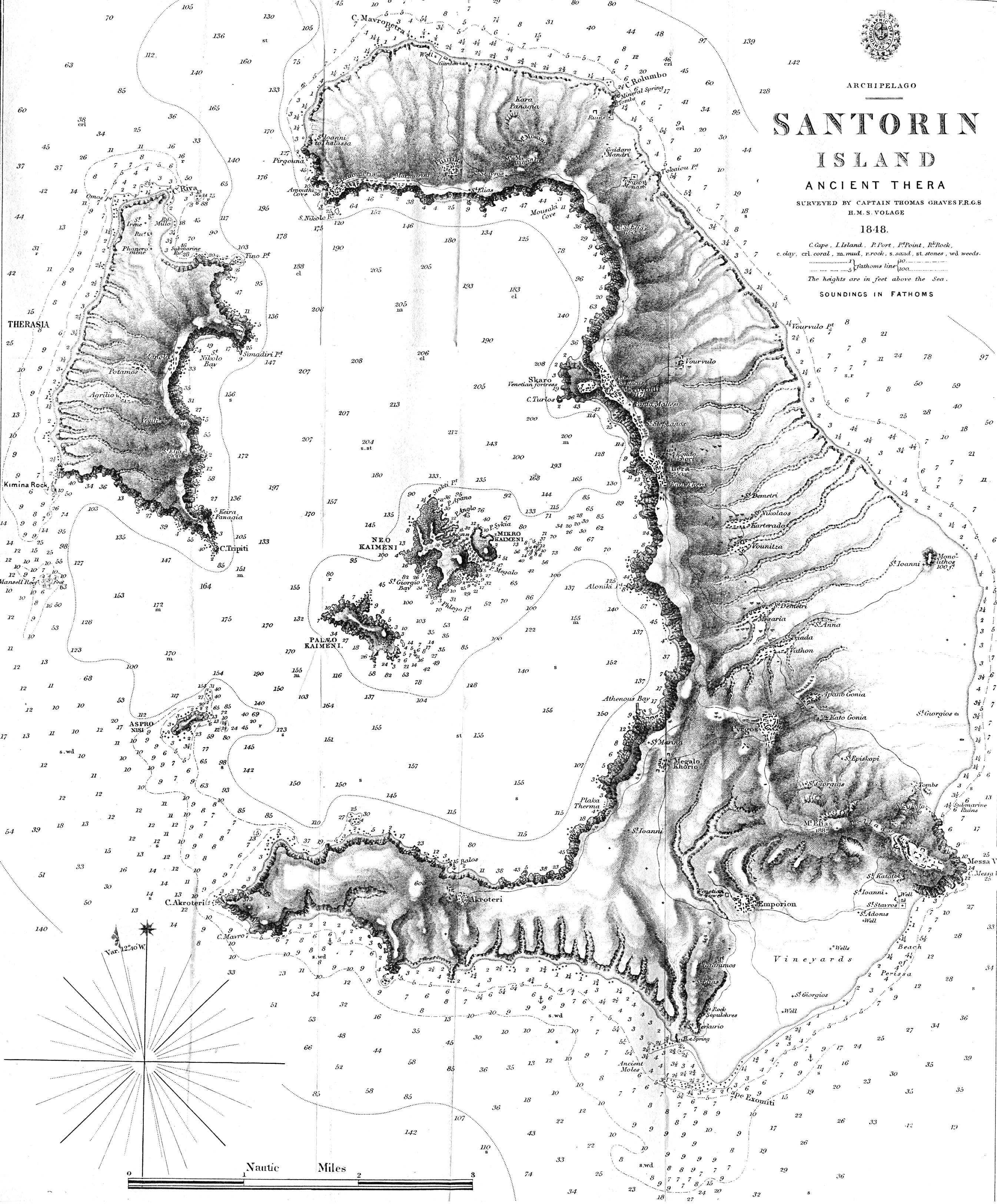
Santorin Island 1848 "Santorin Island Ancient Thera Surveyed by Captain Thomas Graves F.R.G.S. H.M.S. Volage 1848" from The Journal of the Royal Geographical Society, Volume 20, 1850 to accompany "Some Account of the Volcanic Group of Santorin or Thera, once called Calliste, or the Most Beautiful. By Lieut. E. M. Leycester, R.N." (1.63MB)

Λάβετε το καθημερινό newsletter με τα πιο σημαντικά νέα της τουριστικής βιομηχανίας.
Εγγραφείτε τώρα!

