Οι Κεχριές θα μπορούσαν να χαρακτηρισθούν σαν κόμβος που συνδέει τις
ανατολικές με της δυτικές Ευβοϊκές ακτές. Το γεγονός αυτό δημιουργεί ιδανικές
συνθήκες για διακοπές, συνδυάζοντας το πράσινο του χωριού με την ευχέρεια επιλογής
ανάμεσα στις παραλίες του Αιγαίου και του Ευβοϊκού.
Δυτικά του χωριού, στη θέση Καστρί, έχει εντοπιστεί οικισμός της πρωτογεωμετρικής,
γεωμετρικής και κλασικής περιόδου. Οχύρωση των ίδιων περιόδων έχει εντοπιστεί
και στη θέση Στεφάνι, στις Β.Δ. παρυφές του παρακείμενου Μεσοπέτριου όρους, κοντά
στα πλαϊνά χωριά Δάφνη και
Μουρτιά.
Κατά λαϊκή εξήγηση το όνομα του χωριού Κεχριές προέρχεται από την
παραγωγή κεχριού (το φυτό που παράγει τους γνωστούς μικρούς σπόρους, οι οποίοι
χρησιμεύουν μεταξύ άλλων και για τροφή ωδικών πτηνών), ωστόσο λόγω των πολλών
ενδείξεων αρχαίας οίκησης και άλλων ιστορικών στοιχείων δεν αποκλείεται να έχει
σχέση με μεταναστεύσεις και εποικισμούς αρχαίων χρόνων. Οι Κεχριές της Κορίνθου,
των Χανίων και αλλού, ίσως να έχουν σχέση με εποικιστικά γεγονότα παρωχημένων
χρόνων. Με την ονομασία αυτή θα συναντήσουμε το χωριό στο τέλος της Ενετοκρατίας
και στην αρχή της Τουρκοκρατίας (1474), να υπάγεται στο διοικητικό κέντρο των
Ροβιών και να έχει ένα σημαντικό πληθυσμό 25 φορολογούμενων οικογενειών. Σήμερα
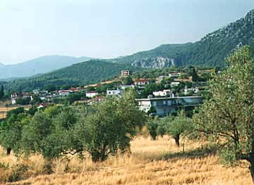
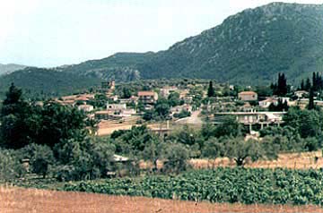
οι Κεχριές είναι ένα ήσυχο και όμορφο χωριό με ποιοτικά γεωργοκτηνοτροφικά προϊόντα
τα οποία τροφοδοτούν τα μεγάλα κέντρα κατανάλωσης. Ο πληθυσμός του χωριού σύμφωνα
με την απογραφή του 1991 ήταν 483 κάτοικοι.
Παραδόσεις και θρύλοι έχουν συνδέσει την ιστορία της βρυσούλας, που
βρίσκεται στην περιοχή, με το μεσαιωνικό χωριό Λιγοτά και με το πέρασμα από εκεί
και του θρυλικού ιππότη Ερωτόκριτου. Μας λέει λοιπόν τραγουδιστά ο Βιτσέντζος
Κορνάρος για την "Λιγοτά" την βρύση του Ερωτόκριτου:
Δίψα μεγάλη γρίκησα στον πόλεμο εκείνο, γυρεύοντας να βρω νερό ίσωσα
έναν πρίνο κι παρα μπρος μου οφανιστή κουτσουναράκι χτύπα. Σιμώνω, βρίσκω το νερό
στου χαρακιού την τρύπα.
Η περιοχή, που κατά την Τουρκοκρατία ήταν τσιφλίκι του Καρά-Αλή, παρεχωρήθη
μετά την απελευθέρωση στον αγωνιστή της επανάστασης Αγγελο Τομπάζη. Μετά από απόφαση
της Ελληνικής Κυβέρνησης το 1925 παρεχωρήθη στους ακτήμονες γεωργούς της περιοχής.
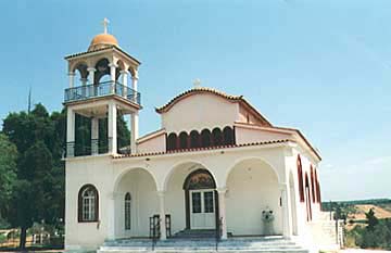
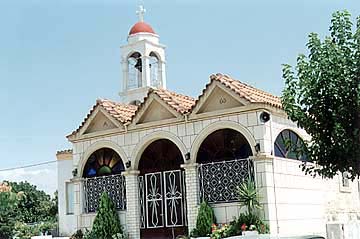
Στην κεντρική πλατεία υπάρχει ο ναός της Κοίμησης της Θεοτόκου, που
είναι και η ενοριακή εκκλησία του χωριού.
Το κείμενο παρατίθεται το Μάιο 2003 από τουριστικό φυλλάδιο του δήμου
Ελυμνίων.
Φωτογραφίες
Xάρτης & Γεωγραφία
Αποστάσεις:
74,5 Χιλιόμετρα Νοτιο-νοτιοανατολικά (ΝΝΑ) η πρωτεύουσα του νομού: ΧΑΛΚΙΔΑ
Πόλη, ΕΥΒΟΙΑ
,
ΕΛΛΑΔΑ
Έχετε την δυνατότητα να δείτε περισσότερες πληροφορίες για γειτονικές ή / και ευρύτερες περιοχές επιλέγοντας μια από τις παρακάτω κατηγορίες και πατώντας το "περισσότερα"
Σχετικά άρθρα από GTP Headlines για την ευρύτερη περιοχή ΧΑΛΚΙΔΑ