Listed 45 sub titles with search on: Archaeological sites for wider area of: "WEST GREECE Region GREECE" .
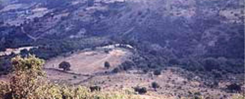
BASSAE (Ancient sanctuary) ILIA

The temple is situated on a slope of Mount Lykaeo and was designed
by Iktinos, the architect of the Parthenon, during the Peloponnesean War at the
end of the 5th century (410 B.C.) to thank god Apollo for his help and to induce
him to banish evil from the area, when great famine had plagued the area. Iktinos'
genius and his refusal to conform to the architectular norms made him combine
the three ancient architectural styles in the most harmonious way; the doric with
the outside pillars, the Ionian with the semipillars and the Corinthian with the
two pillars for the north entrance and the two for the south. On the famous zoeforos
of sculptor Alkamenous dear themes from mythology were reproduced, and it is placed
in the niche of the temple on the top part of the semipillars which supported
the top in contrast with the other temples.
Until 555 A.D. the temple maintained its glamour when an earthquake
and the spreading of Christianity led it to obscurity which was completed in the
Byzantine Years. It was discovered by the French traveller BOUCHET in 1765 A.D.
and it was immediately looted by foreign as well as Turkish smugglers of antiquities.
The English Gropus in cooperation with Veli pasha, governor, then, of Morias,
stripped the temple of all the archaeological remains in 1812. He sold those in
auctions to the rich of the West like the Ionian zoeforos which was bought by
the King of England, George the 4th.
This text is cited Jan 2003 from the Messenia Prefecture Tourism Promotion Commission URL below, which contains image.
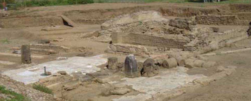
STRATOS (Ancient city) ETOLOAKARNANIA
The project is under the auspices of the Berlin Head Office of the Deutsches Archaologisches Institut.
INIADES (Ancient city) IERA POLIS MESSOLONGIOU
PLEVRON (Ancient city) ETOLOAKARNANIA
STRATOS (Ancient city) ETOLOAKARNANIA
AGIA TRIADA (Village) ILIA
Tel: +30 27230 22448
KAKOVATOS (Village) ZACHARO
Near a Mycaenean settlement at Kakovato three domed tombs have been found.

EGIRA (Ancient city) ACHAIA
Ancient Aigeira (in the province of Achaia) lies on the north coast of the Peloponnese
- roughly opposite Delphi - at the opening of a valley which leads directly into
the Corinthian gulf; together with Pellene, it represents the easternmost city
of the ancient region of Achaia.
Excavated finds revealing human activity and dating to the advanced
late neolithic period have been found on the acropolis hill, which lies 416 m.
above sea level; while excavated remains, in the same location, of a late Mycenaean
settlement of the early 12th century B.C. constitute the beginning of a continuous
settlement. The remains of a mansion and abundant finds point to a settlement
structure, which developed during the period of foreign migrations and can be
situated in the late Mycenaean koine.
In the following period, perhaps already after the 10th century B.C.,
an early Greek sanctuary was erected on the acropolis, a sanctuary which was continually
rebuilt and which continued to be used into the 4th century B.C. A wide spectrum
of votive objects, as well as architectural evidence such as foundation walls
and painted roof tiles, attests to the development of this sacred centre as the
nucleus of the city of Aigeira, a city which, at least in the early period, is
to be connected with the "Hyperesia" of Homeric tradition.
For an evaluation of Aigeira in its prime, that is, at its greatest
extent measuring ca. half a square kilometer and surrounded by a circuit wall,
the excavation results from the theatre terrace in the north, beneath the acropolis
hill, are particularly instructive.
In the course of a thorough new foundation in the hellenistic period,
at about 280 B.C., a monumental, public, sacred civic centre was achieved through
the construction of a theatre and adjacent small temple; this area was continually
rebuilt up until the early Imperial period with further temples and a cult building
dedicated to Tyche. A period of usage prior to that of the theatre-complex is
not to be ruled out for an additional sanctuary to the north, from which foundations
of two further temples are preserved.
In addition to the preserved architectural elements, the sculptural
finds of the 2nd c. B.C., amongst them an over-lifesize head of Zeus by the sculptor
Eukleides, and a draped female conforming to the figure of Tyche, as well as the
mosaic floors of the small temples, attest to the high quality of the fittings
of this space and its buildings.
It is therefore not surprising that even in the 2nd c. A.D. this ensemble
attracted the attention of the travel writer Pausanias, whose short description
absolutely corresponds to the excavated finds.
Two additional public spaces, which currently cannot adequately be
classified, nevertheless at least provide evidence for the complex urban articulation
of the city. Corresponding to this is an extensive infrastructure, which above
all has to do with structures for the provision of water. An aqueduct system which
can be traced for a number of kilometres and which, coming from the south, was
carried over wide stretches through rock tunnels, guaranteed the city's water
supply. This system was continually rebuilt and remained in use from the pre-hellenistic
up until the post-antique period.
Complementing the public and sacred centre, remains of a domestic
building were cut into a terrace directly to the north-west of the acropolis.
An andron, decorated with pebble mosaics and fitted with 11 klinai, attests to
the representative pretension of this building, whose foundation date can provisionally
be placed in the 4th c. B.C. and which in any event predates the construction
of the complex of buildings at the theatre. In spite of sporadic evidence, the
situation of Aigeira for the Roman Imperial period and late antiquity is at the
moment not adequately known.
Research at Aigeira
The discovery of the site and the earliest archaeological investigations date
back to Otto Walter, who, with excavations at the theatre terrace in 1916 and
1925, initiated archaeological research at Aigeira which would have an impact
on the future. As the unstable political situation in Greece only allowed two
short seasons, the research presence of the Austrian Archaeological Institute
(?AI) at Aigeira was in this fashion founded.
The excavation campaigns, from 1972 to 2001 carried out under the
auspices of the central OAI in Wien and since 2002 conducted by the Athens Branch,
have brought to light fundamental evidence concerning the historical development
of this Greek settlement from the late Bronze Age up to the most recent past,
and the appraisal of its material culture.
W. Alzinger led the greatest part of the field research (from 1972-1988),
with systematic surface excavations on the acropolis and on the theatre terrace,
turning aside briefly for excavation in the plain of Palati north of the city.
Besides numerous individual studies on material such as sculpture, ceramic finds,
coins, and the like, as well as the study of the theatre by S. Gogos, a comprehensive
presentation of the historical development of Aigeira has resulted from these
investigations. The remains from the prehistoric and Bronze Age periods found
on the acropolis are currently the focus of intensive research by E. Alram-Stern
(OAW, Myceneaen Commission) and S. Deger-Jalkotzy (OAW, Mycenaean Commission).
Analysis of the ceramic finds from the Greek historical period from the acropolis
excavations is being carried out by G. Schwarz (IKA Graz). Preliminary research
for the final publication of the building elements and the remains from the so-called
Tycheion is the work of T. Hagn (IKA Vienna).
Between the years 1990-1997, A. Bammer pursued a comprehensive urban
survey, and investigated numerous areas of the city via intensive survey, measuring,
and cleaning. These studies incorporate the re-addressing of questions concerning
the water supply, the orientation of numerous extensive public areas, the photographing
of architectural remains from the Byzantine period, and the study of the modern
remains of the so-called "Houses of the Raisin Pickers". A surface excavation
in the plain of Zaoussis led to the partial exposure of the foundations of two
temples north of the theatre terrace.
The most recent excavations by G. Ladstatter (from 1998) continue
the study of the water supply of Aigeira, in connection with hydrogeological studies,
and concentrate on the excavation of the domestic buildings in the plain of Solon
to the north-west of the acropolis.
A selection of objects from the excavations is presented in the Archaeological
Museum at Aigion, while the head of Zeus is displayed in the National Museum at
Athens. The impressive ruins of the theatre with its connected temples, two of
which are protected by a modern shelter, provide an architectural impression of
the hellenistic building ensemble.
Georg Ladstatter. Feb 2004
This text cited Aug 2004 from the Austrian Archaeological Institute's URL http://www.oeai.at/eng/ausland/aigeira.html
which contains 4 images.
Travellers located the city of ancient Elis in the 19th century and indeed
prepared topographical plans. The first systematic excavations were conducted
by the Austrian Archaeological Institute between 1911 and 1914, under the direction
of Otto Walter. Since 1960 excavations have been continued intermittently by
the Archaeological Society at Athens. Rescue excavations carried out by the
VIIth Ephorate of Prehistoric and Classical Antiquities, between 1965 and 1970,
when the irrigation channel of the Peneius dam was being constructed, uncovered
part of the ancient city.
The following buildings were revealed or located and subsequently identified
on the basis of Pausanias' descriptions: Gymnasium, which has not been excavated
but seems to have had the same dimensions as that of Olympia (approx. 200m long);
Baths, to the west of the agora; Temenos of Achilles; Hellanodikaion; 'Southward'
Stoa; 'Corcyraian' Stoa, which was the south border of the agora; various small
sanctuaries; a square building with internal peristyle cort where the sixteen
Eleian women wove the peplos of Hera; a section of the peribolos (enclosure)
of the temenos of Aphrodite; another peribolos of the sanctuary, a small temple
and precincts, among them one of Hades; and finally the theatre to the north
of the agora.
The theatre was built in the 4th century BC and remodelled in Hellenistic and
Roman times. The stoneskin with the proscenium and the paraskenia are among the
oldest in ancient Greece. The audience did not sit in seats but on the hill slope,
just as they did in the stadium of Olympia. Six stone stairways gave access to
the cavea and divided it into seven cunei. An elaborate drainage network safeguarded
the theatre from the danger of flooding. The theatre ceased to function in late
Roman times, when the city in general went into decline, and a cemetary with clusters
of cist and tile-roofed graves was created here.
The Elis Archaeological Collection
Founded in 1981, the Collection includes finds brought to light
in the excavations in Elis. These date from the Early Helladic period to the Roman
Age. Vases, statues, sculptures, funerary stelai, teracotta adn stone architectural
members, figurines, bronze vessels, weapons, coins and other minor objects are
exhibited.
Of particular interest are the broze theatre 'tickets', inscribed with the designation
FA(ΛΕΙΩΝ), meaning 'of the Faleioi', i.e. Eleians, which were found in
large number and date from the late 4th century BC, as well as the teracotta face
masks and the female figurines, which are excellent examples of Eleian coroplastic
art.
Outstanding are the two sections of mosaic floors displayed in the atrium of the
Archaeological Collection. They come from a large villa of the 3rd century AD,
built to the southwest of the agora of Elis. The representations are in circular
arrangement: on one the relate to the Nine Muses and on the other to the Labours
of Herakles.
Xeni Arapoyanni, ed.
Translation by: Alexandra Doumas
Cited Sep 2002, from the Municipality of Amaliada information pamphlet
KATOCHI (Small town) IERA POLIS MESSOLONGIOU
On the west of the village, there is a rocky hill with oak trees, where the remains of the ancient city of Oiniades are situated.
LOUSSES (Ancient city) KALAVRYTA
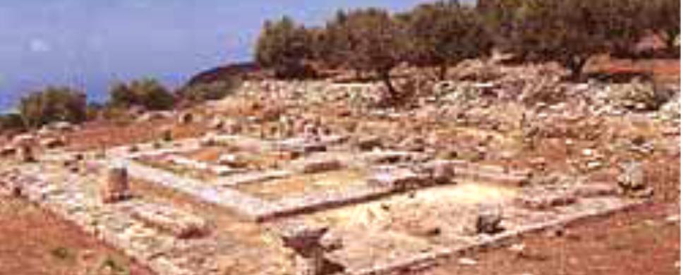
Ancient Lousoi (province of Achaia, Peloponnese), is located on the slopes of
the high valley of Sudena near Kalavrita at an alitude of ca. 1200 m. above sea
level, and in antiquity belonged to the region of Arcadia.
After the discovery of the sanctuary of Artemis Hemera in Lousoi by
W. Dorpfeld and A. Wilhelm in 1897, the sister-institute of the Austrian Archaeological
Institute (OAI) in Athens carried out the first excavations in three campaigns
during 1898 and 1899, under the direction of W. Reichel and A. Wilhelm.
In the sanctuary which extended over two terraced areas, the foundations
of numerous structures were nearly completely exposed, structures which exemplify
the necessary infrastructure of a small rural sanctuary of the 3rd century B.C.
The central building of the sanctuary, the temple of Artemis, was located on the
southern terrace, the higher one; its noteworthy groundplan consists of a central
naos and colonnades connected at the sides. Constructions on the slightly lower
northern terrace accompanied the road to the sanctuary, and according to the interpretation
of the excavators included a fountain house, a "propylon" (gateway) and a "bouleuterion"
(council building). The rapid publication of the architectural elements, as well
as the finds, which include votives connected to the cult of Artemis represents
even today the primary focus of research at the sanctuary.
As part of the excavations, which were renewed in 1980 under the direction
of V. Mitsopoulos-Leon and which continue to date, a survey of the architectural
remains of the extensive settlement area visible in the region has been undertaken
(F. Glaser). To this end, systematic field research has concentrated on excavations
in the sanctuary of Artemis and on the uncovering of domestic housing in the region
of Phournoi, as well as on the measurement of the remains of public structures
in the area called "stadion".
In the sanctuary, the finds recovered from undisturbed stratigraphic
layers reveal the early phase of the cult of Artemis. From the analysis of the
broad spectrum of votive gifts such as bronze jewellery, small figural bronzes
and terracottas, lead and bone votives (V. Mitsopoulos-Leon, Ch. Schauer), pyxides
for the cult and miniature vessels (Ch. Schauer), it is clear that, for the late
geometric and archaic periods, this sanctuary played a leading transregional role,
when seen against the back of similar sacral places. The discovery of the so-called
East Building expands the picture of the architectural layout of the temple terrace,
and points to a possible predecessor of the 4th c. B.C. The complete clearing
of the temple foundations and the search for architectural elements enable to
a great extent the reconstruction and classification of this building from the
turn of the 4th-3rd century B.C. or slightly afterwards. The structure, which
consists of a marble architectural order at the front and in the cella, is divided
into a naos, consisting of pronaos, cella and adyton, and into lateral colonnades
at the sides, comprising a unique solution for a sacred building (G. Ladstatter).
With the excavated remains of two houses from the area of Phournoi,
extending over two terraces, the hellenistic domestic culture of Lousoi can be
clarified. Neither the eastern peristyle house, which probably represents an adaptation
of one or more earlier structures, nor the simpler house to the west, embody canonical
groundplans. Furthermore, the room inventories, with their klinai, bath tubs,
and hearths, indicate a relatively elevated standard of living. The troughs for
wine production located near the domestic area, the evidence for the working of
bones and of ceramic production, as well as storage rooms, point to predominantly
agrarian resources as the economic basis of the people of Lousoi. From a rebuilding,
incorporating numerous stretches of walls, which occurred after the houses were
destroyed all at once probably in the 1st cent. A.D., it can be seen that the
area continued to be used until the late Imperial period.
The preliminary results of a survey in the region called "stadion"
point to a monumental public building in this area. The foundations of a two-aisled
stoa, further traces of walls arranged in a rectangular ground plan, as well as
massive worked ashlar blocks suggest that the remains of a hellenistic civic square
should be identified here.
From this research, beginning with the development of the sanctuary
in the late 8th century B.C., followed by a hellenistic civic settlement covering
an extensive built up area and with the outgoing use of the site in the late Roman
period, important stages of the historical development of the settlement of Lousoi
can be recognised.
The foundations of the Artemis sanctuary and the groundplans of the
houses are visible high above the valley in an impressive location. Until the
construction of a museum at the site, the most important finds are kept in the
Ephorate in Patras.
Veronika Mitsopoulos-Leon Feb 2004
This text cited Aug 2004 from the Austrian Archaeological Institute's URL http://www.oeai.at/eng/ausland/lousoi.html
which contains 3 images and bibliography.
PALEROS (Ancient city) ETOLOAKARNANIA
The most important site is the ancient city of Paleros which was situated
in the current position of Κechropoula in the SE of the peninsula. The city is
believed to exist since the Mycenaean period.
Evidence of that are the walls of the city, part of it belongs to
the second millennium B.C.
The construction of the walls varies between trapezium and polygon
system and they belong to different time periods. The oldest part of the walls
belongs to the Mycenaean period. The port of ancient Paleros was situated in the
current position of Pogonia,
in the SE part of the peninsula. Ruins of marine construction have been found
East of the village.
The fortress was constructed in the middle of 5th century; some believe
is identical to the ancient city of Sollion,
colony of the Corinthians. Today, in that location still exist ruins and the views
of historians regarding the fortress of sterna vary, if there was an ancient city
and what was its name. Others place Sollio, others Νiriko, others place in Sterna
another ancient city with great power. For this opinion substantiates the fact
of the position in which the fortress is located, from which one can have control
of a vast area. Sollio was a marine base of Corinthos, was conquered during the
Peloponnesian war by the Athenians and according to Thoukidides ( 430 B.C.) came
under the control of Palerians-Akarnanians.
The strategic interests of the Athenians from 454 B.C. bring many
conflicts in which the Akarnanian cities are involved during 5th century B.C.
Akarnania during the Peloponnesian war is on the side of the Athenians and at
the end of 5th century B.C. gains power.
North of the city of Paleros is situated lake Voulkaria, or lake Μyrtountion
according to Stavronas. Lake probably leftover of the salt lake that occupied
today’s valley of Paleros during Homer’s time. The salt lake according to the
tradition was the saviour of Queen Cleopatra, when during the battle of Aktion
hunted by her seekers passed with her ships the shallow channel of Paleros. Memory
of the passage of Cleopatra queen of Egypt is the preservation of the name of
the ancient passage as "dock of Cleopatra".
After the victory of Romans in 31 A.D., the prints of ancient Paleros
are lost and historically this is explained by the establishment of Nicopolis
after the battle of Aktio.
The founding of Nicopolis in 30 A.D. is an important event for the distribution
of the population and the whole economy of Aitoloakarnania. The surrounding cities
loose a big part of their potential, as a result they became satellites of the
new Metropolis, this way Ακαrnania
became territorioum of this new city.
Under Trian rule whole of Akarnania belonged to the Imperial district
of Epirus, with base
the ancient Nicopoli. Later, Dioklitian, part of which is today’s Aitoloakarnania,
recognizes Nicopoli as base of Old Epirus. Since, Aitoloakarnania is linked with
the fate Byzantine Empire, of which was part. Paleros was among the cities mentioned
in ancient times and during the Roman period.
If we go back in time, in second millennium B.C., we will see that
that the peninsula of Plagia
was an autonomous island. Plagia is situated on the NW tip of Aitoloakarnania
and is separated from Lefkas by a canal that ancient Corinthians built during
600 B.C. with objective to improve transportation between the Ionian
sea and Patraiko gulf.
The channel separated Lefkas
island from Aitoloakarnania. They were connected through a network of swamps and
islets.
The argument of the existence of Plagia as an island is supported
by the fact that the valley of Paleros is below the sea level with sand type of
soil, where there was sea which cut off the peninsula that Plagia is located today
from the rest of Aitoloakarnania with a swamp that extended from the bay of today's
Paleros to the bay of Ag.
Nikolaos of Vonitsa. Leftover of the swamp is the lake
Voulkaria, which is connected today with the sea by a canal.
The view that Plagia was an island in the Homer years generates theories
regarding the existence and actual location of "Homeric" Ithaka in Plagia.
German researcher Doerpfeld, suggests that the Plagia Peninsula belongs to the
geographic arrangement of "Homeric" Ithaka (Homer Odyssey). He equates
the ancient city of Paleros with "Homeric" Nirikos, he believes that
Nirikos was on the hill of St. Georgios where today exists the fort of St. Georgios.
Views of researchers vary on the location of "Homeric" Ithaka
and many theories have been created.
According to German researcher Doerpfeld, the peninsula of Plagia
was initially an island, believed to be the "Homeric country" of Kefallineans,
where the ancient city of Nirikos
existed, it was conquered by Laertis and incorporated with Ithaka, as the Kefallines
became warriors of Odysseus. According to this theory, in the peninsula of Plagia,
which is used today as in ancient times for shepherding, Odysseus could have had
his schools of pigs, sheep, goats and cows. For Voukoulo Filoitio the poet informs
us he lived in the city of Kefallineans. Kegallines lived in the time of Odysseus
across in the mainland, and the herds of Odysseus according to Odysseus (ξ, 100
and υ, 210) were located in the peninsula of the mainland and at the same time
in the region of Kefallines.
PLAGIA (Village) AKTIO - VONITSA
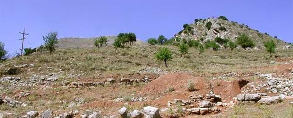
The archeological place of Sterna, which is situated o the peak of
the mountain over the old Plagia. There is an ancient wall and two watch towers
on the two hills opposite the area of Sterna.
This text (extract) is cited August 2003 from the Municipality
of Kekropia tourist pamphlet.
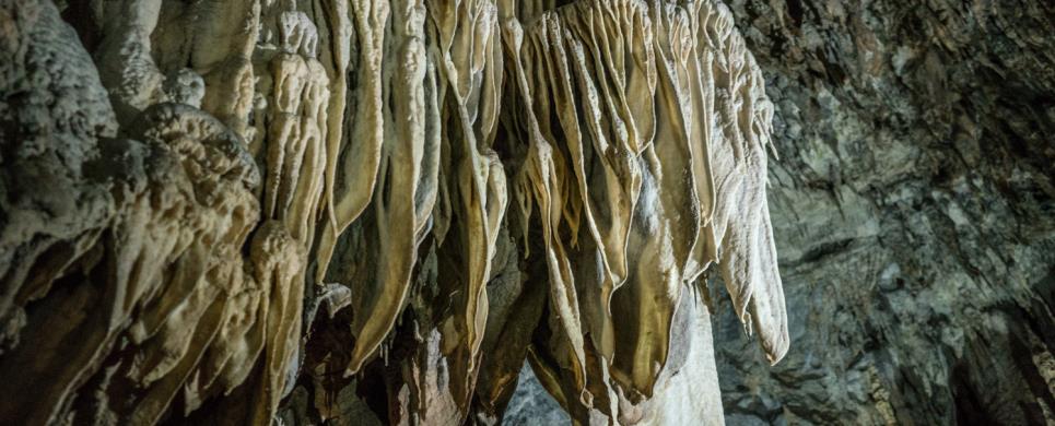
KASTRIA (Village) KALAVRYTA
Tel: +30 26920 31633
Fax: +30 26920 31588
In the village Kastria of Achaia,
60km from Tripoli (tunnel
at Artemision) and 9 Km from
Kleitoria, lies the famous
“Cave of the Lakes”.
It is a rare creation of Nature. Apart from its labyrinth of corridors,
its mysterious galleries and its strange stalactite formations, the “Cave
of the Lakes” has something exclusively unique that does not exist in other
well known caves. Inside the cave there is a string of cascading lakes forming
three different levels that establish its uniqueness in the world.
The cave is an old subterranean river whose explored length is 1980
meters. In winter when the snow melts, the cave is transformed into a subterranean
river with natural waterfalls. In the summer months, part of the cave dries up
revealing a lace-work of stone-basins and dams of up to 4 m. in height. The rest
of the cave retains water permanently throughout the year in 13 picturesque lakes.
TOURIST ROUTE
The developed part of the cave is currently 500 meters long. It includes
artistic lighting. The visitor enters the cave through an artificial tunnel which
leads directly to the second floor. The dimensions of this part of the cavern
create awe, rapture, admiration. The passage from lake to lake is possible by
small man-made bridges.
PALEONTOLOGICAL INTEREST
At the cave’s lower floor, human and animal fossils
were found, among which that of a hippopotamus. This part of the cave is intended
to become a biological cave laboratory of international standing.
THE CAVE’S LEGEND
The legend says that the daughters of Proitos, king of Tirynth, Lyssippi,
Ifinoy and Ifianassa, bragged that they were more beautiful than the Goddess Hera
and scorned the worship of the God Dionysus. Zeus’s mate didn’t forgive
their vanity and took their sanity, causing them to believe that they were heifers
running wild on the mountains and meadows of Peloponnisos,
infecting the women of Argolida
with the craze of infanticide. Someday they arrived at the cave of Aroanios
were they were found by Melambodas who cured them. He then led them to the village
Loussoi.
EXPLORATION - DEVELOPMENT OF THE CAVE
In 1965, the residents of the valley of Kastria reached for
the first time the second floor, using wooden ladders from a 9 meter ramp. The
cave was explored by the E.O.S. (Hellenic Alpine Club) with the help of Prof.
I. Melendis and mapped by the E.S.S. (Hellenic Speleological Society) under the
supervision of Mrs. Anna Petrochilou. The development of the cave began in 1981
by E.O.T. (Hellenic
Tourism Organization) and continued from the former community of Kastria. Today
the municipality of
Lefkasio is responsible for the cave’s operation and is resided at Kleitoria
(Mazeika).
EGIRA (Ancient city) ACHAIA
Tel: +30 210 8213708
Fax: +30 210 8220798
LOUSSES (Ancient city) KALAVRYTA
Tel: +30 210 8213708
Fax: +30 210 8220798

PATRAI (Ancient city) ACHAIA
Tel: +30 2610 276207
It was built shortly before the Odeion of Herodes Atticus in Athens
(161 A.D.) and is smaller than the Athenian monument. The cavea has four rows
of seats in the lower section, and seven in the upper part, over the diazoma.
The outer, tall wall of the stage (skene) has five entrances to the skene and
the lateral buildings (paraskenia). Access to the proskenion is gained through
two built stairways, one on the left and one on the right side. The orchestra
is paved and separated from the cavea by a semicircular parapet. The Odeion was
revealed in 1889 and until then it was completely covered with earth. Only restricted
excavation has been carried out on the site.
The monument
was repaired and again dressed with marble slabs after World War II.
Every summer the Odeion is employed for music concerts and theatrical
performances.
On the West side of the acropolis, at the upper town, lies the Roman
Odeum of Patras, erected
prior to the Athens Odeum. (Herodeum, 160 AD). Pausanias, that visited Patras
in the decade of 170AC writes, "It has the most beautiful decoration I have ever
seen, after that of Athens". As Pausanias reports, inside the Odeum that used
to be a continuance of the Agora, there was a statue of Apollo, made of the loots
of the war against the Galatians (279 BC), when Patras people had helped the Etolians.
In the centuries that followed, earthquakes, wars and conquerors destroyed
the Odeum and covered it with other buildings and ground. A small hill was created,
which covered almost the entire Odeum. The Odeum saw daylight again in 1889, when
there have been some works of digging to collect ground for the banking up of
the port.
A lot of decades went by until the process of restoration begun, which
was completed in 1956, the year that the Odeum regained its initial shape. On
the same decade, the surroundings were turned into an archaeological site, housing
the exhibition of sarcophagi, mosaics and other ancient findings.
The Odeum contains all the basic parts of a theatre such as hollow,
orchestra, proscenium, scene and wings as well as 23 rows of seats, while its
capacity is 2300 spectators.
After the establishment of Patras International Festival, the Ancient
Odeum constitutes its main venue, welcoming in the summer months, top Greek and
foreign artistic bands.
This text is cited Feb 2003 from the Municipality of Patra URL below, which contains image.
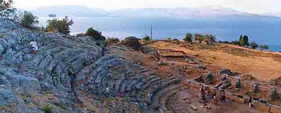
THERMON (Ancient city) ETOLOAKARNANIA
Site: Thermon
Type: Bouleuterion
Summary: Rectangular building; in the southeast corner of the Sanctuary
of Apollo Thermios.
Date: ca. 350 B.C. - 160 B.C.
Period: Late Clas./Hell.
Plan:
Rectangular meeting hall opening on the north.
History:
Also known as the Aetolian Council Hall.
This text is cited Nov 2002 from The Perseus Project URL below, which contains 2 image(s), bibliography & interesting hyperlinks.
Site: Thermon
Type: Stoa
Summary: Stoa; at the southeast corner of the Sanctuary of Apollo
Thermios.
Date: ca. 275 B.C. - 216 B.C.
Period: Hellenistic
Plan:
Two-aisled stoa opening west with a Doric outer colonnade.
This text is cited Nov 2002 from The Perseus Project URL below, which contains 2 image(s), bibliography & interesting hyperlinks.
Site: Thermon
Type: Fountainhouse
Summary: Rectangular structure with zig-zag channel; in the Sanctuary
of Apollo Thermios, between the Temple of Apollo and the Middle Stoa.
Date: ca. 300 B.C. - 200 B.C.
Period: Hellenistic
Plan:
Small three-sided building fitted with spouts and opening southwest. A zig-zag
channel from it runs roughly east-west.
History:
The fountain and channel still function.
This text is cited Nov 2002 from The Perseus Project URL below, which contains 3 image(s), bibliography & interesting hyperlinks.
Site: Thermon
Type: House
Summary: 'Hair-pin' shaped house; on the north side of the Sanctuary
of Apollo, partly under the northwest corner of the Temple of Apollo Thermios.
Date: ca. 1400 B.C. - 1100 B.C.
Period: Late Bronze Age
Plan:
Long apsidal building opening southwest. On the south end, extended antae, possibly
returning, formed a deep porch, the porch rear wall opened onto a long nearly
rectangular room with a door on its north end leading into a room in the apse.
This text is cited Nov 2002 from The Perseus Project URL below, which contains 4 image(s), bibliography & interesting hyperlinks.
Site: Thermon
Type: Temple
Summary: Three-roomed structure; beneath the later Temple of Apollo
Thermios.
Date: ca. 1000 B.C. - 680 B.C.
Period: Geometric
Plan:
Long, narrow building, with deep porch, large central room and a small rear room.
Slightly curving rear wall.
History:
The function of the slightly apsidal 10th century B.C. structure is uncertain.
The peristyle of wooden posts resting on stone slabs appears to have been added
later, possibly in the 8th or 7th century B.C. The apsidal colonnade of wooden
posts surrounding Megaron B would make it the earliest example of a temple with
a colonnade, and the only example of an apsidal peristyle, but Lawrence suggests
the relation of these posts to Megaron B is probably coincidental.
This text is cited Nov 2002 from The Perseus Project URL below, which contains 1 image(s), bibliography & interesting hyperlinks.
Site: Thermon
Type: Stoa
Summary: Stoa; in the Sanctuary of Apollo Thermios, running north-south
between the Temple of Apollo and the South Stoa.
Date: ca. 275 B.C. - 216 B.C.
Period: Hellenistic
Plan:
Two-aisled stoa opening east with buttressed rear wall on the west.
This text is cited Nov 2002 from The Perseus Project URL below, which contains 1 image(s), bibliography & interesting hyperlinks.
Site: Thermon
Type: Peribolos Wall
Summary: Wall with towers; surrounding the Sanctuary of Apollo Thermios.
Date: ca. 250 B.C.
Period: Hellenistic
Plan:
Nearly rectangular peribolos wall with square towers built at regular intervals,
and round towers guarding the southwest entry. Another entry on the northern wall.
History:
The entire wall is not preserved. Although remains at the sanctuary date to earlier
periods, the protective walls are from the 3rd century B.C.
This text is cited Nov 2002 from The Perseus Project URL below, which contains bibliography & interesting hyperlinks.
Site: Thermon
Type: Stoa
Summary: Stoa; on the south side of the Sanctuary of Apollo Thermios,
parallel to the southern sanctuary wall.
Date: ca. 275 B.C. - 216 B.C.
Period: Hellenistic
Plan:
Two-aisled stoa with probable Doric outer colonnade, opening north. Buttressed
rear wall.
This text is cited Nov 2002 from The Perseus Project URL below, which contains 4 image(s), bibliography & interesting hyperlinks.
Site: Thermon
Type: Temple
Summary: Narrow peripteral temple; at the northern end of the Sanctuary
of Apollo Thermios.
Date: ca. 630 B.C. - 610 B.C.
Period: Archaic
Plan:
Doric peripteral temple, 5 x 15 columns, with two-aisled cella opening south directly
onto the peristyle. The first of the 10 interior columns stood in the space between
the antae of the cella. Opisthodomos with 2 columns on the north.
History:
Built over the remains of Megaron B. The wooden columns were later replaced by
stone. Northwest of the temple may have been a small Temple of Apollo Lyseios,
and to the east, a small Temple of Artemis.
This text is cited Nov 2002 from The Perseus Project URL below, which contains 29 image(s), bibliography & interesting hyperlinks.
KALYDON (Ancient city) IERA POLIS MESSOLONGIOU
Region: Aetolia
Periods: Archaic, Classical, Hellenistic
Type: Fortified city and sanctuary
Summary: Setting of the Kalydonian boar hunt.
Physical Description:
N of the entrance to the Gulf of Corinth, Kalydon was a
minor city enclosed by a 4 km long circuit wall (3rd century B.C. date) and a
strongly fortified acropolis. A sacred road ran ca. 400 m from the West City Gate
to the Sanctuary of Artemis Laphria. The sanctuary had originally 2 Archaic temples
dedicated to Artemis and Apollo. During the Classical and Hellenistic period the
sanctuary developed to include a number of stoas, treasuries and other structures.
Description:
Kalydon was recorded by Homer as the home of Oeneus and
the setting of the Caledonian boar hunt. The historical city is little known and
apparently unimportant, but the growth of the Sanctuary of Artemis, the construction
of the city's walls in the 3rd century B.C., and the size of some of the Hellenistic
tombs indicate some prosperity. The city declined in the Roman period, and in
30 B.C. Augustus transferred the inhabitants to the new city of Nikopolis.
Exploration:
Early description of the remains by Leake (1835) and Woodhouse
(1897). Excavations on the acropolis and at the sanctuary of Artemis Laphria in
1908 by G. Sotiriadis. In 1926, 1928, and 1932 joint Greek-Danish excavations
carried out under F. Poulsen and K. Romaios.
Donald R. Keller, ed.
This text is cited Oct 2002 from The Perseus Project URL below, which contains 13 image(s), bibliography & interesting hyperlinks.
THERMON (Ancient city) ETOLOAKARNANIA
Region: Aetolia
Periods: Late Bronze Age, Geometric, Dark Age, Archaic, Classical,
Hellenistic
Type: Sanctuary
Summary: Sanctuary of Apollo and meeting place of the Aetolian League.
Physical Description:
Located on a mountain plateau above the NE shore of Lake Trichonis
in W Central Greece, the fortified temenos occupied an area of 340 by 200 m. It
contained 3 temples, 3 stoas, a fountain and spring, agora, and a bouleuterion
as well as exedra and votive sculpture. Fragmentary remains of an early (ca. 630-610
B.C.) Doric temple were found below the later temple of Apollo Thermios and above
the so-called Megaron B, a possible temple of Geometric date. There was also a
temple of Artemis at the sanctuary.
Description:
The site was first settled in the Late Bronze Age. At sometime
in the Geometric period the site took on a religious character as evidenced by
the remains of Megaron B, a cult building with an elliptical colonnade (which
may, however, have been added at a later date). Above the Megaron B temple an
Archaic temple was built which was then replaced after 206 B.C. by the final temple
of Apollo Thermios. In the Classical period the site became a Pan-Aetolian sanctuary
and the meeting place for members of the Aetolian League. Annual festivals were
held and the election of magistrates took place in the bouleuterion at the site.
The fortification of the sanctuary probably occurred after the invasion of Antipater
and Krateros in 323 B.C. Thermon was plundered by Philip V of Macedon in 218 and
206 B.C., but it continued to function until ca. 168 B.C. when the League was
reduced. The discovery of 1st century B.C. graves in the temenos area indicates
that the site was no longer a sacred precinct by this time.
Exploration:
Excavations: 1896-1916, G. Soteriades, Greek Archaeological
Society.
Donald R. Keller, ed.
This text is cited Oct 2002 from The Perseus Project URL below, which contains 19 image(s), bibliography & interesting hyperlinks.
PATRAI (Ancient city) ACHAIA
Patras was rendered a Roman colony in 31BC and the dominance of Roman architecture has been all-embracing. Many public buildings and works were constructed at the expense of Roman Emperors and the benefactors of the city. One of these works was the Roman aqueduct, necessary in a populous city like Patras. It was the time that Patras was going through the most flourishing period in its history, occupying its position as Greece's gate to Italy. Romans constructed a large water reservoir at the sources of Romanos river, where Diakoniaris torrent rises. The reservoir was constructed in the form of an artificial dam at the beginning of the glade, at ten meters distance from the sources. A part of the initial wall of the dam is incorporated today at the base of the contemporary reservoir, while 20m away, inside the river's bed, there are large pieces of a strong wall. At the sources of Romanos River, as it derives from an inscription discovered last century, they worshiped Nymphs, deities of water. Patras' aqueduct, from the reservoir to the fortress, was 6.5km long. Water was transferred at its biggest part through a built ground pipe, passing through valleys and gullies on well-looked-after arches, parts of which survive till nowadays. There were branch-pipes towards several directions with covered pipes of smaller cross-section. The constant water flow was accomplished thanks to the principle of communicating vessels, of which Greeks were aware.
This text is cited Feb 2003 from the Municipality of Patra URL below.

Receive our daily Newsletter with all the latest updates on the Greek Travel industry.
Subscribe now!

