EN
Greek Travel Pages
EN
Επιλογές χρήστη
Είσοδος
Εγγραφή
Επιλογές χρήστη
Είσοδος
Εγγραφή
Menu
Αρχική
Προορισμοί
Ξενοδοχεία
Επιχ/σεις & οργανισμοί
Ακτοπλοϊκά δρομολόγια εσωτερικού
Αναχωρήσεις & αφίξεις πλοίων εσωτερικού
Ακτοπλοϊκά δρομολόγια από/προς Ελλάδα
GTP Ferry Connections
Ελληνικά Λιμάνια
Ναυτιλιακές εταιρίες
Κατάλογος πλοίων
Προσφορές
Nέα
Εργασία
eBook
Αρχική
Προορισμοί
Ξενοδοχεία
Επιχ/σεις & οργανισμοί
Ακτοπλοϊκά δρομολόγια
Ακτοπλοϊκά δρομολόγια εσωτερικού
Αναχωρήσεις & αφίξεις πλοίων εσωτερικού
Ακτοπλοϊκά δρομολόγια από/προς Ελλάδα
GTP Ferry Connections
Ελληνικά Λιμάνια
Ναυτιλιακές εταιρίες
Κατάλογος πλοίων
Προσφορές
Nέα
Εργασία
eBook
Προορισμοί
ΕΛΛΑΔΑ
ΚΕΦΑΛΛΟΝΙΑ
ΠΑΣΤΡΑ
Φιλικό URL:
http://www.gtp.gr/Pastra
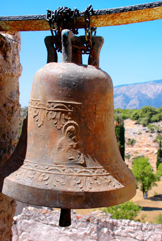
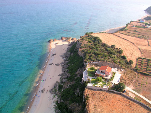
Φωτογραφίες
Xάρτης & Γεωγραφία
Ξενοδοχεία, επιχειρήσεις, προορισμοί & οδηγίες
Τοπικές πληροφορίες
Ειδησεογραφία
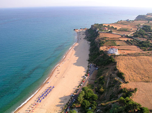
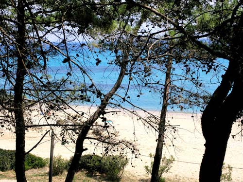
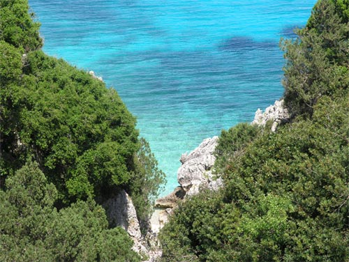
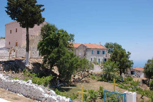
ΠΑΣΤΡΑ, Χωριό, ΚΕΦΑΛΛΟΝΙΑ
Φωτογραφίες
Εμφανίζονται
10
από συνολικά
72
φωτογραφίες που βρέθηκαν για ΚΕΦΑΛΛΟΝΙΑ.
Δείτε όλες τις φωτογραφίες για ΚΕΦΑΛΛΟΝΙΑ
Xάρτης & Γεωγραφία
Εμφάνιση/Απόκρυψη Χάρτη
Αναγνωρισμένοι οικισμοί του Δ.Δ:
ΚΡΕΜΜΥΔΙ
Οικισμός,
ΚΕΦΑΛΛΟΝΙΑ
,
ΕΛΛΑΔΑ
Αποστάσεις:
32 Χιλιόμετρα Βορειοδυτικά (ΒΔ) η πρωτεύουσα του νησιού:
ΑΡΓΟΣΤΟΛΙ
Πόλη,
ΚΕΦΑΛΛΟΝΙΑ
,
ΕΛΛΑΔΑ
Αρχαίοι τόποι στα όρια του Δημ. Διαμερίσματος:
ΠΡΟΝΝΟΙ
Αρχαία πόλη,
ΚΕΦΑΛΛΗΝΙΑ
,
ΕΛΛΑΔΑ
Υψόμετρο
280 μέτρα
Γ. Μήκος
20
o
45' 00.31" E
Γ. Πλάτος
38
o
05' 39.64" N
Ξενοδοχεία, επιχειρήσεις, προορισμοί & οδηγίες
34
Σχετικοί Προορισμοί
Προβολή
52
Ξενοδοχεία & διανυκτέρευση
Προβολή
75
Επιχειρήσεις & οργανισμοί
Πολιτιστικά μνημεία
Θρησκευτικά μνημεία
Δημόσιες Αρχές
Προβολή όλων
Δρομολόγια πλοίων
ως αφετηρία
ως προορισμό
ΒΡΕΣ ΔΡΟΜΟΛΟΓΙΟ
Τοπικές πληροφορίες
Χαρακτηρισμός τόπου
Εδρα δήμου, Δημοτικό Διαμέρισμα
Ταχ. Κωδικός
28082
Κάτοικοι
Έτος
Πληθυσμός
1991
200
1981
245
Αναφορές & Παραπομπές
Επιλέξετε μία ενότητα πληροφοριών από την παρακάτω λίστα ή
πατήσετε εδώ για να τις δείτε όλες
(3)
Κεντρικές σελίδες
2
Αξιοθέατα
2
Αρχαιολογικοί χώροι
8
Αρχές τοπικής αυτοδιοίκησης
10
Βιογραφίες
1
Εορτές & πανηγύρια
6
Ιστορία
4
Μύθοι & θρύλοι
1
Μυθολογία
1
Παραλίες
5
Πληροφορίες για τον τόπο
3
Προσκυνήματα
30
Χρήσιμες πληροφορίες
3
Έχετε την δυνατότητα να δείτε περισσότερες πληροφορίες για γειτονικές ή / και ευρύτερες περιοχές επιλέγοντας μια από τις παρακάτω κατηγορίες και πατώντας το "περισσότερα"
Πληροφορίες για τους επισκέπτες
Κεντρικές σελίδες
British tourism firms featuring the area:
Photo Album
Shopping
Travel & Tourism enterprises dealing with Greece
UNESCO - World Heritage List
Αδελφοποιήσεις
Αθλητικά γεγονότα
Αθλητικοί χώροι
Αθλητισμός & Σπορ
Ανασκαφές & ευρήματα
Αναφορές για τον τόπο
Ανθελληνικές θέσεις
Αξιοθέατα
Αποστάσεις
Αρχαία Γραμματεία
Αρχαία έργα τέχνης
Αρχαίες πηγές
Αρχαιολογικά ευρήματα:
Αρχαιολογικές ερευνες στον τόπο από:
Αρχαιολογικοί χώροι
Αρχές τοπικής αυτοδιοίκησης
Ασχολίες των κατοίκων
Βιβλιογραφία
Βιογραφίες
Βιότοποι
Βοήθεια αναζήτησης
Γεύσεις του τόπου
Γεωλογία
Διαμονή & διασκέδαση
Διαφημιζόμενοι στο χώρο:
Διπλωματικό Σώμα
Εθνικά Μονοπάτια
Ειδικές μορφές τουρισμού
Εισερχόμενος τουρισμός
Εκθέσεις
Ελληνική Δημοκρατία
Ενοικιάσεις αυτοκινήτων
Εορτές & πανηγύρια
Εορτές, αγώνες & ιεροπραξίες αρχαίων
Επαγγελματικές Ενώσεις
Επιλεγμένες επιχειρήσεις τουρισμού
Επισκέψεις επωνύμων
Εστίαση & Διασκέδαση
Εταιρείες θαλάσσιου τουρισμού & μεταφορών
Ευρωπαϊκά Μονοπάτια
Ηλεκτρονικές βιβλιοθήκες
Ημερήσιος & Περιοδικός Τύπος
Θέατρα & Κινηματογράφοι
Θέματα γραμμάτων & τεχνών
Θέματα κοινωνικά
Θέματα του τόπου
Θεοί του τόπου
Θρησκευτικές βιογραφίες
Θρησκευτική ιστορία
Ιστορία
Κέντρα πολιτισμού & τέχνης
Κέντρα υγείας
Κόμβοι - Αρχαία Ελλάδα
Κόμβοι - Αρχαία Ελληνική Ιστορία & Προϊστορία
Κόμβοι - Αρχαία Ελληνική Μυθολογία
Κόμβοι - Αρχαία Ελληνική Φιλοσοφία
Κόμβοι - Αρχαίες Ελληνικές Επιστήμες
Κόμβοι - Αρχαίος Ελληνικός Πολιτισμός
Κόμβοι - Ελληνική Αρχαιολογία
Κυβέρνηση
Λεηλασίες του τόπου:
Μνημεία που αναφέρονται από αρχαίους
Μουσεία όπου εκτίθενται ευρήματα του τόπου:
Μύθοι & θρύλοι
Μυθολογία
Ναυτιλιακές εταιρείες
Ξενοδοχεία, Ενοικιαζόμενα & Κάμπινγκ
Ο Ελληνισμός του τόπου
Οι κάτοικοι του τόπου
Οικισμοί με σειρά εξυπηρέτησης του χώρου
Οικονομία
Ολυμπιακοί Αγώνες
Ομηρικός κόσμος
Ομορφες διαδρομές
Ονομασία του τόπου
Παλαιολιθικά ευρήματα
Πανεπιστήμια
Πανίδα
Παραδοσιακά επαγγέλματα
Παραδοσιακά προϊόντα
Παραλίες
Πληροφορίες αεροδρομίων
Πληροφορίες για Ελλάδα
Πληροφορίες για τον τόπο
Πληροφορίες ελικοδρομίων
Πλοηγός
Πολιτική γεωγραφία
Πολιτιστικά γεγονότα
Ποτά του τόπου
Προϊόντα
Προσκυνήματα
Πρόσωπα σχετικά με τον τόπο
Προτιμάται από επισκέπτες
Συγκοινωνίες
Σύλλογοι Πολιτών
Συνειρμική ταύτιση
Συνώνυμα τοπωνύμια
Τοπικές εκδρομές
Τοπωνύμια
Χαρακτηριστικά του τόπου
Χιονοδρομικό κέντρο
Χλωρίδα
Χρήσιμες πληροφορίες
Σχετικά άρθρα από GTP Headlines για την ευρύτερη περιοχή ΚΕΦΑΛΛΟΝΙΑ
Περισσότερα άρθρα για την ευρύτερη περιοχή ΚΕΦΑΛΛΟΝΙΑ
Γεωγραφική θέση
ΠΑΣΤΡΑ
(Χωριό, Εδρα δήμου) ανήκει στον τόπο
ΕΛΕΙΟ - ΠΡΟΝΟΙ
(Δήμος)
ΕΛΕΙΟ - ΠΡΟΝΟΙ
(Δήμος) ανήκει στον τόπο
ΚΡΑΝΑΙΑ
(Επαρχία)
ΚΡΑΝΑΙΑ
(Επαρχία) ανήκει στον τόπο
ΚΕΦΑΛΛΟΝΙΑ
(Νησί)
ΚΕΦΑΛΛΟΝΙΑ
(Νησί) ανήκει στον τόπο
ΚΕΦΑΛΛΗΝΙΑ
(Νομός)
ΚΕΦΑΛΛΗΝΙΑ
(Νομός) ανήκει στον τόπο
ΙΟΝΙΑ ΝΗΣΙΑ
(Σύμπλεγμα νήσων)
ΙΟΝΙΑ ΝΗΣΙΑ
(Σύμπλεγμα νήσων) ανήκει στον τόπο
ΕΛΛΑΔΑ
(Χώρα)
Εξερευνήστε επίσης...
ΑΓΙΑ ΕΙΡΗΝΗ Χωριό
ΑΓΙΟΣ ΝΙΚΟΛΑΟΣ Χωριό
ΑΝΝΙΝΑΤΑ Οικισμός
ΑΡΓΙΝΙΑ Χωριό
ΒΑΛΕΡΙΑΝΟΣ Χωριό
ΚΟΡΝΕΛΛΟΣ Οικισμός
ΚΡΕΜΜΥΔΙ Οικισμός
ΜΑΡΚΟΠΟΥΛΟ Χωριό
ΜΑΥΡΑΤΑ Χωριό
ΞΕΝΟΠΟΥΛΟ Χωριό
ΠΡΟΝΝΟΙ Αρχαία πόλη
ΣΚΑΛΑ Χωριό
ΧΙΟΝΑΤΑ Χωριό
Λάβετε το καθημερινό newsletter με τα πιο σημαντικά νέα της τουριστικής βιομηχανίας.
Εγγραφείτε τώρα!
Αναχωρησεις πλοιων
Διαφημίσεις