Listed 54 sub titles with search on: Main pages for wider area of: "MAKEDONIA EAST & THRACE Region GREECE" .
AMORI (Village) DIDYMOTICHO
Tel: +30 25530 31354
ANTHOCHORI (Village) DRAMA
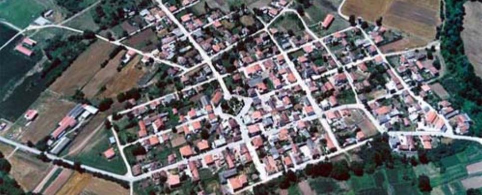
AVDIRA (Municipality) XANTHI
The newly-established Kapodistrian Municipality of Avdera came out
of the unity of four former Communities and includes nine villages. It spreads
around a place of 16.400 hectare and possesses the largest part of the coastal
zone of the prefecture of Xanthi.
The brilliant historical route from antiquity to these days, the rich
cultural inheritance and tradition and the rare natural watery wealth are the
typical features of the multi-faced Municipality of Avdera and make it an outstanding
and blessed area. The wider region is regarded as an area of ecological importance
and it is protected by the International Convention "Ramsar". The hydrobiotic
place of Vistonida lake with
300 different kinds of birds, lagoons Lafri and Lafrouda, the beautiful beaches
with the clear waters and the fine sandy beaches, the thick plantation and the
picturesque harbours of Avdera
and Porto Lagos, compose
a mosaic of rare natural beauty which captivates every visitor.
This text (extract) is cited October 2003 from the Municipality
of Avdera tourist pamphlet.
CHARITOMENI (Village) DRAMA
CHRYSSOKEFALOS (Village) DRAMA
Tel: +30 25230 22594
DIDYMOTICHO (Town) EVROS
Didymoteichon, today a small town of approximately 12000 people, bears
a long and extremely noteworthy history.
The city is lying next to the Erythropotamos
river, on the western bank of the famous Hevros
river.
The first habitation was founded on the Hagia Petra hill at the Southeastern
end of the city in the Neolithic period, according to recent excavational evidence.
During the Early Iron Age two villages existed together in both hills of the city,
Hagia Petra and Kales, the second lying at the western end of today’s Didymoteichon.
Abundant quantities of ceramics (local, imported Attic & Thasian pottery
etc.) as well as other findings form the ancient historic times witness not only
the existence of a city at that period but, even more, its close relations with
the Greeks.
During the "Pax Romana" the emperor Traianos re-established
the city, honouring it with the name of his wife, Plotina. Plotinopolis became
one of the most important cities of Roman Thrace,
being itself under an autonomous regime. The city reached a remarkable status
of welfare, reflected on random findings or results of the few excavational works
done up to now: floor mosaics representing the Hercules deeds and the Zeus-Swan
and Leda legend, or the famous golden head of the emperor Septimus Severus. The
decadence of the Empire & the barbaric invasions & lootings caused the gradual
transportation of the city from the hill of Hagia Petra to that of Kales. It's
perhaps then that Didymoteichon took its last name, if we accept that it means
Twin (= δίδυμο) castles. During the Byzantine period the importance of the city
is growing, because of its crucial geostragetic position and its steep, impregnable
stronghold of Kales where it lied. This constantly growing significance is well
marked by writers of the Middle and Late Byzantine times Greeks as well as foreigners,
like Godfried Villeharduin, who stresses that "Ditymoteichon was the strongest
and one of the richest cities of Romania" (= the territory of the Byzantine
empire). Especially during the Paleologian period (13th and first half of the
14th century) Didymoteichon becomes the focus of the historical events: capital
of the emperors Andronicos the Third the Paleologos and Ioannis the Sixth Kantakouzenos
during the catastrophic civil wars of 1321 to 1354, also witnesses the birth of
"Purple-born" emperors, as well as royal weddings, imperial army, inauguration
of two emperors, etc. Unfortunately only recently excavations have began to bear
in light the expected traces of this glorious past:
An imperial foundation nest to Agios Athanassios post-byzantine church
where the excavation has revealed a peculiar structure and some unique fragments
of byzantine frescoes, the humble funeral chapel of Hagia Aikaterini, the hundreds
of rock-cut caves, shaped by the mediaeval inhabitants of the city as cisterns
or storerooms at the back of their houses and of course the byzantine walls retaining
building phases form Justinian time to the early Ottoman period on the surfaces
of the towers and in the castle one can still can see monograms of byzantine nobles,
imperial families etc.
The Turkish occupation holds for more than 550 years, from 1361 to
1920 and is characterized from an extraordinary early ottoman building activity,
parallel to the choice of the city as a temporary capital of the empire.
On the other hand the greek element has a thriving presence and through
the years becomes the dominating factor socially, economically & culturally as
is shown by the vast quantities of the exported Didymoteichon pottery and the
post byzantine churches with the marvelous wooden temples and icons, offered by
the powerful professional unions.
The city was liberated in 1920, 19th of May.
This text (extract) is cited September 2003 from the Municipality
of Didymoteichon tourist pamphlet (1995).
KALI VRYSSI (Village) DRAMA
KAVALA (Town) MAKEDONIA EAST & THRACE
Gorgeous scenery, fascinating historical monuments, superb beaches,
plus all the services and facilities accompanying sound tourist development, await
the visitor to Kavala, one of the gems of eastern
Macedonia.
A city with a distinguished past, Kavala occupies the site of the
ancient Neapolis. Its buildings
rise like the tiers of an amphitheatre up the slopes of Mt. Simvolo, overlooking
the picturesque harbour. The area has been settled since Neolithic times (3.000
B.C.), while Antisara, covering the present villages of Kalamitsa
and Kipoupolis just outside town, was founded in the 5th century B.C. Neapolis,
of some what later date, knew great prosperity thanks to its strategic location
in the region: its proximity to the gold mines on Mt.
Pangeo, on the one hand, and its position on the main trade route uniting
East and West on the other. Much later, in commemoration of St. Paul’s visit,
Neapolis was renamed Christoupolis.
Over the course of time, the region of Kavala had a turbulent history
of invasions, wars and oppression before evolving into the important commercial
centre it is today. Besides having an active port, Kavala is the capital of the
tobacco industry in Greece.
Although a modern buisiness centre, Kavala is amply endowed with charms
to attract and captivate any visitor, for it has managed to hold onto many features
of its former appearance, resulting in a graceful balance of old and new. The
spacious squares, contemporary constructions, shops and warehouses on the West
side of the city blend harmoniously with the old houses with their gardens and
enclosed balconies that jut out over the flagstones of the narrow alleyways on
the east side. Traditional and modern meet and merge both in Kavala’s architecture,
and its layout.
Furthermore, its up-to-date facilities for tourists, its nightclubs
and its tavernas provide all the amenities while offering endless possibilities
for a most pleasant stay.
Kavala’s harbour is particularly beguiling, filled with dozens
of brightly coloured fishing caiques bobbing up and down at the quay before set
out at twilight, lamps lit for the night’s adventure.
This text (extract) is cited August 2003 from the Greek
National Tourism Organization tourist pamphlet (1988).
KOMOTINI (Town) RODOPI
Tel: +30 25310 39000, 39104
Fax: +30 25310 39035
LAVARA (Small town) DIDYMOTICHO
MONI DADIAS (Monastery) SOUFLI
Tel: +30 25540 51361
MONI KORNOFOLIAS (Monastery) SOUFLI
MONI TAXIARCHON (Monastery) XANTHI
Tel: +30 25410 22362, 29911
NEA KESSANI (Small town) XANTHI
Tel: +30 25410 96269, 96732
PALEOCHORI (Small town) KAVALA
Tel: +30 25920 43225
Fax: +30 25920 43889
PENTALOFOS (Village) ORESTIADA
Tel: +30 25560 61216
PROSSOTSANI (Small town) DRAMA
SELERO (Village) XANTHI
Tel: +30 25410 31333, 31531, 31200
Fax: +30 25410 31200, 31531, 31333
TOPIRO (Municipality) XANTHI
The Muncipality of Topeiros is the result of the unity of the former
Communities of Avato, Galani,
Exohi, Erasmio,
Evlalo, Maggana,
Olvio, Toxotes.
Its expanse is 312,5m2. It consists of 36 settlements and its population is about
14.500 people.
The North section of the Municipality of is mountainous and composes
part of the mountain range of Rodopi.
It has rich vegetation, with rare flora and fauna, deep ravines with a large number
of small streams, which join the Nestos river.
All the west side is traversed by the Nestos
river, which has its springs in Bulgaria.
Its natural flow creates meanderings, which are surrounded by steeps areas with
aquatic vegetation forming a distinctive landscape, known as the "NARROWS
of NESTOS". The Southern
part of the Municipality and the biggest one is flat and covered with arable lands.
There are some hilly as well as swampy lands, mostly near the coastline of Thracian
Sea and the "DELTA" of Nestos.
The narrows and the "Delta" of Nestos
are the most important natural resources. The Delta of Nestos
was characterized as one of the ten most valuable wetlands of Europe. According
to scientific and ecological point of view, it offers a very rich variety of fauna.
Finally, the water of Nestos
consists a significant agricultural resource.
The Municipality of Topeiros has 3 Gymnasiums (High schools), 28 Elementary
Schools and 11 Kindergartens. There are also Infant-private medical offices, dental
clinics and many pharmacies.
Topeiros has a lot of cultural associations, women’s clubs,
athletic clubs and fields. Also, theatrical-dancing, photography, music and environment
clubs operate in the area.
This text (extract) is cited October 2003 from the Municipality
of Topeiros tourist pamphlet.
VISTONIDA LAKE (Lake) XANTHI
All visitors of Xanthi should not miss going to Vistonida Lake with
its canals and reed thickets surrounding it as well as the small delta of the
rivers flowing into it. Lagoons such as Lafre, Lafrouda, Alyki, Elos and Porto
Lagos complete this natural beauty. In the Porto Lagos lagoon one can visit the
chapels of St Nicholas and Virgin Mary which are built on small islets.
Lake Vistonida was formulated 5,000,000 years ago. It was named after
the Vistons, a Thracian tribe living around. The area of the lake is 42 sq.km.
The size of the lake decreases and increases alternately for almost 6 sq.km.,
depending on the season. The average depth of the lake is 2 ? 2.5 m. (max. 3 m.).
It is a peculiarity of Vistonida Lake that there are great fluctuations
in the salt content of its water. Thus, the water in the Northern part of the
lake is brackish because of the influx of three rivers: Kosynthos, Kompsatos and
Travos. On the contrary, the Southern part of the lake has salty water because
of three canals connecting the lake with the sea.
All sorts of birds, in impressive numbers, dominate the area. There
is also a great variety in vegetation and fauna. The silent (for human ears) world
of fish amounts to 37 different species (including striped grey mullets and eels)
in the lake. The animals living around are either carnivorous or herbivorous at
various sizes. Wild cats, jackals and badgers seek refuge in the forests, the
bushes and the delta of Kompsatos River, whereas, at a larger scale, there are
wolves and roes.
This text is cited July 2003 from the Prefecture of Xanthi URL below, which contains map.


Receive our daily Newsletter with all the latest updates on the Greek Travel industry.
Subscribe now!